Birkenwerder
commune allemande
Cet article est une ébauche concernant une localité allemande.
Vous pouvez partager vos connaissances en l’améliorant (comment ?) selon les recommandations des projets correspondants.
Birkenwerder est une commune de Brandebourg (Allemagne), située dans l'arrondissement de Haute-Havel.
| Birkenwerder | |||

| |||
 Armoiries |
|||
| Administration | |||
|---|---|---|---|
| Pays | |||
| Land | |||
| Arrondissement (Landkreis) |
Arrondissement de Haute-Havel | ||
| Bourgmestre (Bürgermeister) |
Stephan Zimniok | ||
| Code postal | 16547 | ||
| Code communal (Gemeindeschlüssel) |
12 0 65 036 | ||
| Indicatif téléphonique | 03303 | ||
| Immatriculation | OHV | ||
| Démographie | |||
| Population | 8 141 hab. () | ||
| Densité | 450 hab./km2 | ||
| Géographie | |||
| Coordonnées | 52° 41′ 00″ nord, 13° 17′ 00″ est | ||
| Altitude | 32 m |
||
| Superficie | 1 810 ha = 18,1 km2 | ||
| Localisation | |||
| Géolocalisation sur la carte : Allemagne
Géolocalisation sur la carte : Brandebourg
| |||
| Liens | |||
| Site web | www.birkenwerder.de | ||
| modifier |
|||


Démographie
modifier-
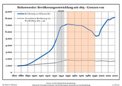 Évolution démographique dans les limites actuelles depuis 1875.
 -
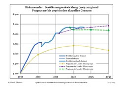 Évolution recente (ligne bleue) et prévisions sur l'effectif de résidents.


|
|
|
|
|
Personnalités liées à la ville
modifier- Hartmut Eichler (1937-2007), chanteur né à Birkenwerder.
Notes et références
modifier- Les sources de données se trouvent en detail dans les Wikimedia Commons Population Projection Brandenburg at Wikimedia Commons