Fichier:1718 Chatelain Map of Java - Geographicus - Java-chatelain-1718.jpg

Taille de cet aperçu : 800 × 363 pixels. Autres résolutions : 320 × 145 pixels | 640 × 290 pixels | 1 024 × 464 pixels | 1 280 × 580 pixels | 2 560 × 1 161 pixels | 6 000 × 2 721 pixels.
Fichier d’origine (6 000 × 2 721 pixels, taille du fichier : 5,01 Mio, type MIME : image/jpeg)
Ce fichier et sa description proviennent de Wikimedia Commons.
| Artiste |
|
|||||||||||||||||||||||
| Titre |
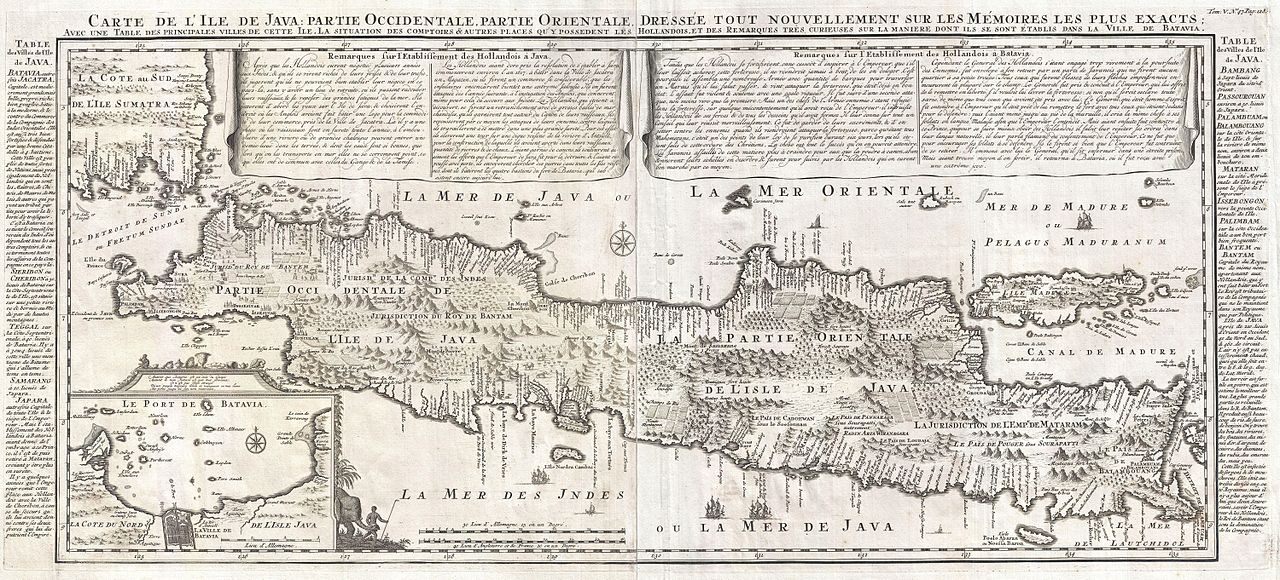
Carte de l'Ile de Java: partie Occidentale, partie Orientale, Dressée tout nouvellement sur les Mémoirs les plus exacts; Avec une Table des principales villes de cette Ile, La situation des comptoirs & autres places qu'y possedent les Hollandois, et des Remarques très curiueuses sur la maniere dont ils se sont établis dans la Ville de Batavia. |
|||||||||||||||||||||||
| Description |
English: A beautiful example of Henri Chatelain's important 1718 map of Java. Covers the island in full as well as adjacent parts of Sumatra and Bali. Offers beautiful engraving and extraordinary detail throughout, noting rice plantations, mountain ranges, grazing lands, forests, and in many places, elephants and gazelle. The previously unknown southern shore is mapped both correctly and in considerable detail. Also shows some offshore reefs and other dangers. The volcanic island of Krakatau, here identified as Cracatao, which nearly 150 years later would erupt with devastating consequences, appears in the Strait of Sunda between Java and Sumatra. In the lower left quadrant an inset details the city and port of Batavia, then the center of Dutch East Indian Company's activity in the region. Appearing in tapestry style windows at the top of the map is an area of extensive text. Composed by Gueudeville, this is a discussion of the history of the lands and countries depicted. Additional textual data referencing the cities and villages of Java, appears to the left and right of the map proper. In its day Chatelain's map of Java was by far the most sophisticated study of the island yet published. Previous to this map, the most advanced cartographic rendering of Java was Van der Aa's 1714 mapping of the region, which though it correctly identified general form of Java's northern shore, identified the southern shore as Parte Incognita. Of course the Dutch were active in this region since the 17th century and had no doubt produced accurate manuscript charts of the island, but these were carefully guarded trade secrets controlled by the powerful Vereenigde Oostindische Compagnie (V.O.C. or Dutch East India Company). The publication of Chatelain's map of Java, offered here, suggests that Chatelain somehow obtained his data from a source outside of the V.O.C. That Chatelain's map was copied by Johannes Van Keulen II, the V.O.C.'s own cartographer, nine years later suggests that even the V.O.C., who maintained an active presence on the island, did not possess more accurate data. It is highly likely that Chatelain extracted much of his cartographic information on Java from Hadrien Reland, a Dutch scholar and philologist who composed a number of works on the Indonesian Archipelago in the early 18th century. A highly important map of the region and a must for an serious collection focusing on the East Indies. Prepared by Henri Chatelain for publication in his monumental seven volume 1718 Atlas Historique . |
|||||||||||||||||||||||
| Date | 1718 (undated) | |||||||||||||||||||||||
| Dimensions | hauteur : 15,5 pouces (39,3 cm) ; largeur : 35 pouces (88,9 cm) | |||||||||||||||||||||||
| Numéro d’inventaire |
liens Geographicus : Java-chatelain-1718 |
|||||||||||||||||||||||
| Source / photographe |
Chatelain, H. A., Atlas Historique, volume V, pate 47, page 128, 1718 edition.
|
|||||||||||||||||||||||
| Autorisation (Réutilisation de ce fichier) |
|
|||||||||||||||||||||||

Historique du fichier
Cliquer sur une date et heure pour voir le fichier tel qu'il était à ce moment-là.
| Date et heure | Vignette | Dimensions | Utilisateur | Commentaire | |
|---|---|---|---|---|---|
| actuel | 24 mars 2011 à 04:35 | | 6 000 × 2 721 (5,01 Mio) | BotMultichillT | {{subst:User:Multichill/Geographicus |link=http://www.geographicus.com/P/AntiqueMap/Java-chatelain-1718 |product_name=1718 Chatelain Map of Java |map_title=Carte de l'Ile de Java: partie Occidentale, partie Orientale, Dressée tout nouvellement sur les M� |
Utilisation du fichier
Les 2 pages suivantes utilisent ce fichier :
Usage global du fichier
Les autres wikis suivants utilisent ce fichier :
- Utilisation sur su.wikipedia.org