Fichier:1864 Johnson's World Mountains and Rivers Map or Chart - Geographicus - MtsRvrs-johnson-1864.jpg
Taille de cet aperçu : 437 × 599 pixels. Autres résolutions : 175 × 240 pixels | 350 × 480 pixels | 560 × 768 pixels | 747 × 1 024 pixels | 1 494 × 2 048 pixels | 3 647 × 5 000 pixels.
Fichier d’origine (3 647 × 5 000 pixels, taille du fichier : 5,86 Mio, type MIME : image/jpeg)
Ce fichier et sa description proviennent de Wikimedia Commons.
| Artiste |
|
||||||||||||||||||||||
| Titre |
Johnson's Chart of Comparative Heights of Mountains, and Lengths of Rivers of Africa. Johnson's Chart of Comparative Heights of Mountains, and Lengths of Rivers of Asia. Johnson's Chart of Comparative Heights of Mountains, and Lengths of Rivers of Europe. Johnson's Chart of Comparative Heights of Mountains, and Lengths of Rivers of South America. Johnson's Chart of Comparative Heights of Mountains, and Lengths of Rivers of North America. |
||||||||||||||||||||||
| Description |
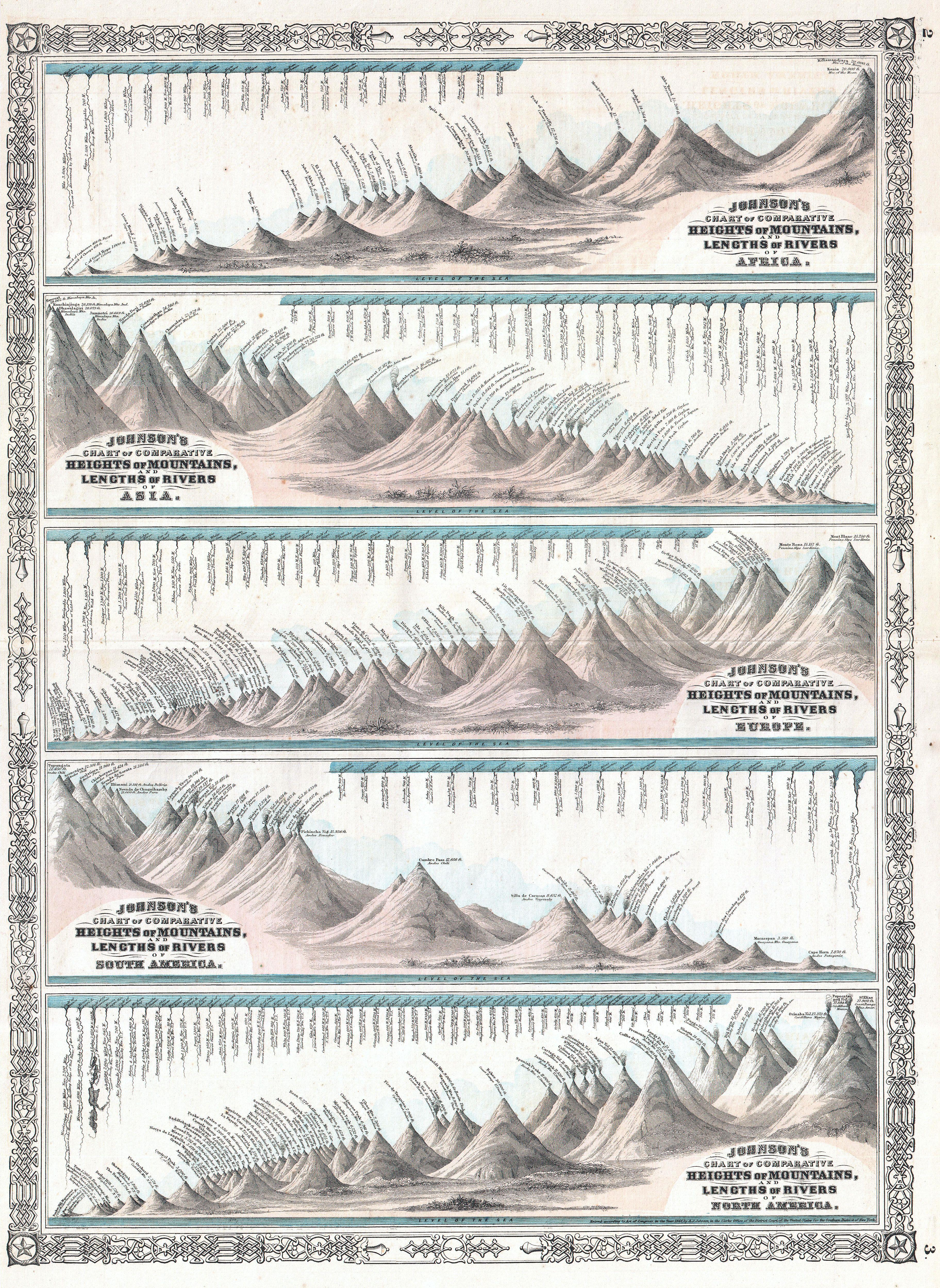
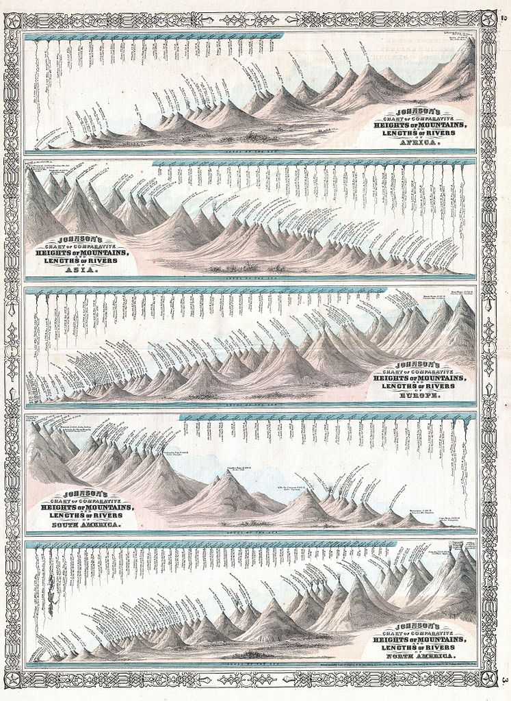
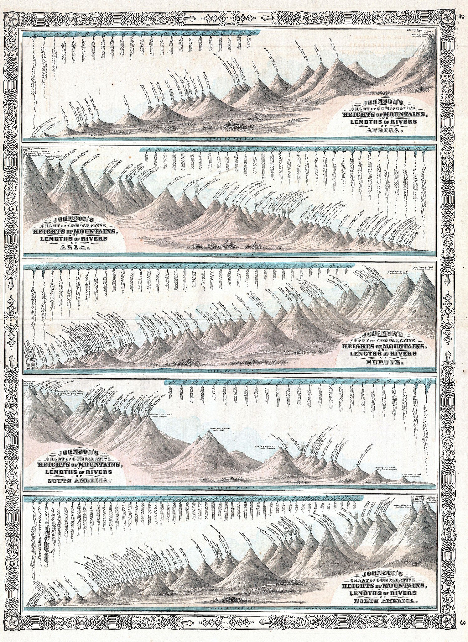
English: This is the 1864 edition of Johnson's Mountains and Rivers Chart. This chart, printed in 1864, represents a significant reimagining and re-engraving of Johnson's pre-1864 mountains and rivers charts. Johnson first introduced a mountains and rivers chart in the second edition of his atlas, published in 1861. That chart, based on a related 1855 chart engraved by J. H. Colton, was very similar to other topical charts common in European atlases of the period in that it presented all of the great mountains and rivers of the world in a single panoramic view. Johnson, perhaps recognizing that the traditional chart, which necessarily highlighted the primacy of the great mountains and rivers of Asia, was difficult to read with regard to the regions that interested his constituent readers - North Americans and Europeans. Thus Johnson re-engraved his chart, taking the bold step of dividing the world's great mountains and rivers by continent. This curious move made the map more accessible on a continental level. Johnson's 1864 mountains and rivers chart can also be read from a political perspective, for by dividing the mountains according to continents, each continent's mountains appear equally great. While Johnson is not the first to focus his mountains and rivers chart on particular continent, this is the first example we are aware of that consolidate the mountains and rivers all of the continents, each represented individually, on a single chart. The chart is ordered roughly alphabetically in five sections, with Africa at the top, followed by Asia, Europe, South America and North America. Curiously Johnson chooses to place North America below South America - a clear break his is alphabetical sequence. This unusual move is possibly in deference to the perceived greater importance of North America relative to its southerly cousin. In the Africa section, Kilimanjaro is identified as the highest mountain, and the Nile its longest river. This chart also includes the Great Pyramid. In the Asia second, Everest, at 29,000 feet is recognized as the highest mountain and the Yangtze as the longest river. In the Europe section, the highest mountain is Mont Blanc and the Volga is recognized as the longest River. IN South America, Tupungato (Tupungata), at 22, 450 feet is identified as the highest mountain (Aconcagua is a sad no. 2) and the Amazon is the greatest River. North America, still not fully explored when this map was published lists Mt. St. Elias, of the Canadian Yukon, as the highest mountain, followed by the Popocatepetl and Orizaba volcanoes of Mexico. This is in fact somewhat reversed from actuality, with Orizaba being the highest at 18,504 feet, followed by Elias at 18,009 feet, and Popocatepetl at 17,930. At this time, neither Mount McKinley (Denali) nor Mount Logan, the true highest peaks of North America, had been measured. Even so, Johnson does correctly recognized the Mississippi as the continent's longest river. Published by A. J. Johnson as plate nos. 2-3 for issue in the 1864 edition of Johnson's Family Atlas . Dated an copyrighted, 1864. |
||||||||||||||||||||||
| Date | 1864 (dated) | ||||||||||||||||||||||
| Dimensions | hauteur : 23,2 pouces (59 cm) ; largeur : 17,2 pouces (43,8 cm) | ||||||||||||||||||||||
| Numéro d’inventaire |
liens Geographicus : MtsRvrs-johnson-1864 |
||||||||||||||||||||||
| Source / photographe |
Johnson's New Illustrated (Steel Plate) Family Atlas, (1864 edition).
|
||||||||||||||||||||||
| Autorisation (Réutilisation de ce fichier) |
|
||||||||||||||||||||||
Historique du fichier
Cliquer sur une date et heure pour voir le fichier tel qu'il était à ce moment-là.
| Date et heure | Vignette | Dimensions | Utilisateur | Commentaire | |
|---|---|---|---|---|---|
| actuel | 17 mars 2011 à 20:48 | | 3 647 × 5 000 (5,86 Mio) | BotMultichill | {{subst:User:Multichill/Geographicus |link=http://www.geographicus.com/P/AntiqueMap/MtsRvrs-johnson-1864 |product_name=1864 Johnson's World Mountains and Rivers Map or Chart |map_title=Johnson's Chart of Comparative Heights of Mountains, and Lengths of Ri |
Utilisation du fichier
La page suivante utilise ce fichier :