Fichier:1996 Hurricane Bertha radar loop 1996-07-12.gif

Pas de plus haute résolution disponible.
1996_Hurricane_Bertha_radar_loop_1996-07-12.gif (788 × 487 pixels, taille du fichier : 9,03 Mio, type MIME : image/gif, en boucle, 41 trames, 21 s)
Ce fichier et sa description proviennent de Wikimedia Commons.
Description
| Description |
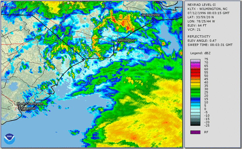
Français : Boucle radar de l'ouragan Bertha montrant l'atterrissage de la tempête le long de la côte des comtés de New Hanover et de Pender en Caroline du Nord. La boucle se déroule de 4 h 03 à 18 h 41 le 12 juillet 1996.
English: Hurricane Bertha radar loop showing landfall of the storm along the coast of New Hanover and Pender counties in North Carolina. Loop runs from 4:03 AM to 6:41 PM on July 12, 1996. |
| Date | |
| Source | https://www.weather.gov/images/ilm/climate/Bertha1996/Bertha-radarLoop.gif |
| Auteur | NWS Office in Wilmington, NC |
Conditions d’utilisation
This image is in the public domain because it was stored on the web servers of the U.S. National Weather Service. NWS-created images are automatically public domain in the U.S. since the NWS is a part of the U.S. government. However, the NWS sites also host non-NWS images which have been submitted by individuals: these are generally shown as "Courtesy of ...". Such images have explicitly been released to the public domain by the copyright owner as part of the upload process.
As stated at https://www.weather.gov/fsd/disclaimer: "By submitting images, you understand that your image is being released into the public domain. This means that your photo or video may be downloaded, copied, and used by others." Thus, all* images on NWS servers are public domain (including "Courtesy of ..." and “Photo by ...” images) unless specifically stated otherwise through a copyright (©) watermark.
*A deletion discussion in November 2023 ruled that Getty Images on the web servers of NWS, are to be considered copyrighted, even without a copyright (©) watermark and are the sole exception to this rule.
|
Historique du fichier
Cliquer sur une date et heure pour voir le fichier tel qu'il était à ce moment-là.
| Date et heure | Vignette | Dimensions | Utilisateur | Commentaire | |
|---|---|---|---|---|---|
| actuel | 16 juillet 2020 à 01:08 | | 788 × 487 (9,03 Mio) | Pierre cb | Uploaded a work by NWS Office in Wilmington, NC from https://www.weather.gov/images/ilm/climate/Bertha1996/Bertha-radarLoop.gif with UploadWizard |
Utilisation du fichier
La page suivante utilise ce fichier :