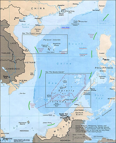
Fichier:9 dotted line.png

Taille de cet aperçu : 487 × 600 pixels. Autres résolutions : 195 × 240 pixels | 390 × 480 pixels | 979 × 1 206 pixels.
Fichier d’origine (979 × 1 206 pixels, taille du fichier : 1,79 Mio, type MIME : image/png)
Historique du fichier
Cliquer sur une date et heure pour voir le fichier tel qu'il était à ce moment-là.
| Date et heure | Vignette | Dimensions | Utilisateur | Commentaire | |
|---|---|---|---|---|---|
| actuel | 21 octobre 2011 à 23:29 |  | 979 × 1 206 (1,79 Mio) | Cantons-de-l'Est | {{Information |Description={{en|Map of the South China Sea, with 9-dotted line highlighted in green<br/> en:Category:South China Sea en:Category:Spratly Islands en:Category:Paracel Islands}} |Source=Transferred from [http://en.wikipedia. |
Utilisation du fichier
La page suivante utilise ce fichier :
Usage global du fichier
Les autres wikis suivants utilisent ce fichier :
- Utilisation sur ar.wikipedia.org
- Utilisation sur az.wikipedia.org
- Utilisation sur ca.wikipedia.org
- Utilisation sur cs.wikipedia.org
- Utilisation sur de.wikipedia.org
- Utilisation sur en.wikipedia.org
- Utilisation sur es.wikipedia.org
- Utilisation sur it.wikipedia.org
- Utilisation sur ja.wikipedia.org
- Utilisation sur ko.wikipedia.org
- Utilisation sur no.wikipedia.org
- Utilisation sur pl.wikipedia.org
- Utilisation sur pt.wikipedia.org
- Utilisation sur ru.wikipedia.org
- Utilisation sur sv.wikipedia.org
- Utilisation sur ta.wikipedia.org
- Utilisation sur th.wikipedia.org
- Utilisation sur tr.wikipedia.org
- Utilisation sur uk.wikipedia.org
- Utilisation sur www.wikidata.org
- Utilisation sur zh.wikipedia.org
- Utilisation sur zh.wikinews.org
