Fichier:AS17-M-0443.jpg
Fichier d’origine (1 012 × 1 012 pixels, taille du fichier : 258 kio, type MIME : image/jpeg)
Ce fichier et sa description proviennent de Wikimedia Commons.
Description
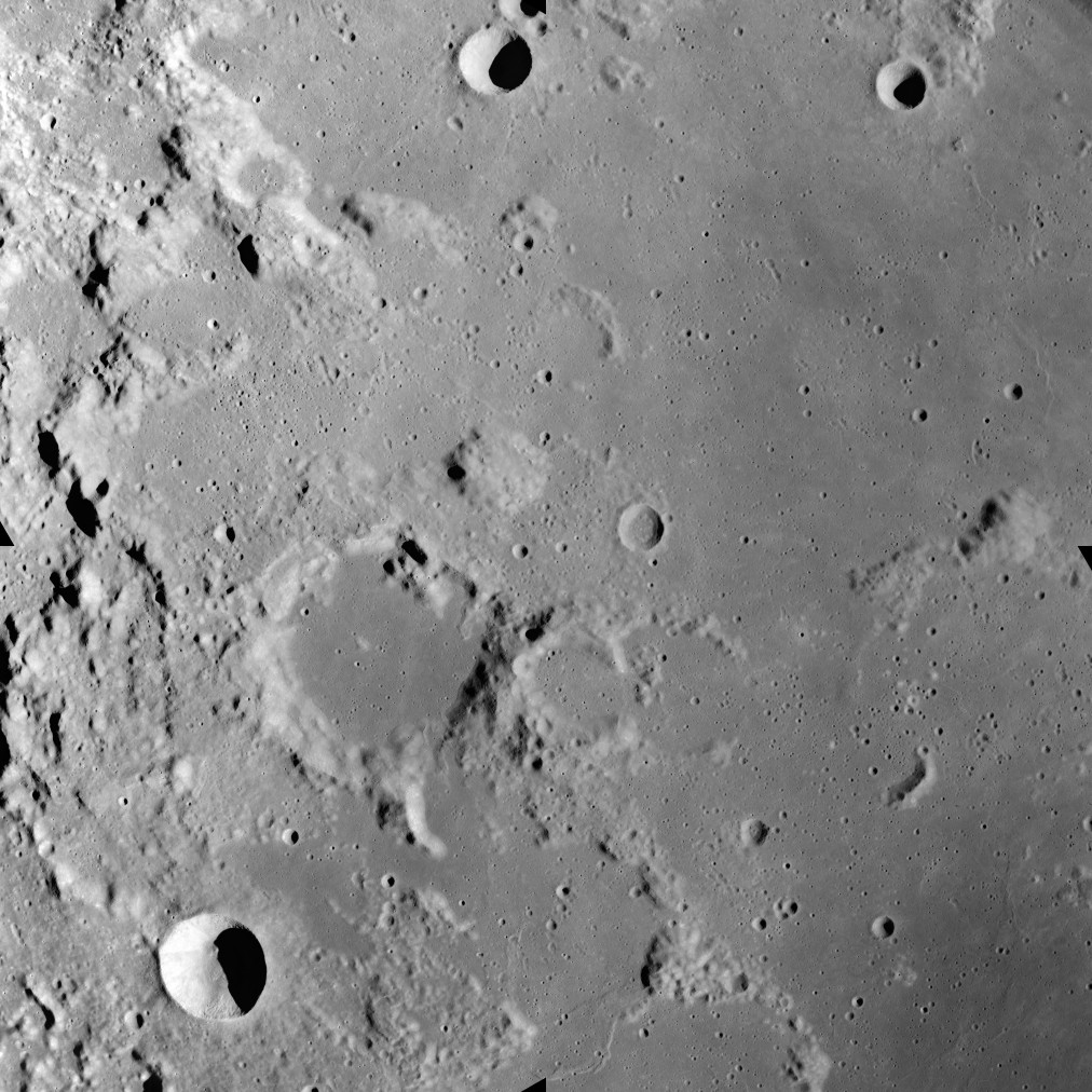
This image was taken during the Apollo 17 mapping metric sequence, revolution #14. The selenographic coordinates of this image are 20° N, 35.90° E.
At the center of this image is the dome-like Mons Maraldi, and just to the southwest is the flooded Maraldi crater. Most of the eastern half of this view is occupied by the Sinus Amoris, a lunar mare, and the flooded remnants of older formations. The bowl-shaped crater in the southwest corner is Gardner, and the cup-shaped crater at top-center is Franck.
This picture was produced by reducing a Hi-res image to 25% of full size, then rotating 90° counter-clockwise so that north is toward the top edge.
Source: Lunar & Planetary Institute, http://www.lpi.usra.edu/resources/apollo/frame/?AS17-M-0443 [1]
Conditions d’utilisation
| Ce fichier provient de la NASA. Sauf exception, les documents créés par la NASA ne sont pas soumis à copyright. Pour plus d'informations, voir la politique de copyright de la NASA. | ||
 |
Attention :
|
Historique du fichier
Cliquer sur une date et heure pour voir le fichier tel qu'il était à ce moment-là.
| Date et heure | Vignette | Dimensions | Utilisateur | Commentaire | |
|---|---|---|---|---|---|
| actuel | 19 juin 2018 à 22:22 | | 1 012 × 1 012 (258 kio) | Jstuby | higher resolution, better quality, from ASU |
| 27 janvier 2006 à 19:58 |  | 601 × 600 (90 kio) | RJHall | Maraldi crater and surroundings from Apollo 17. |
Utilisation du fichier
La page suivante utilise ce fichier :
Usage global du fichier
Les autres wikis suivants utilisent ce fichier :
- Utilisation sur ca.wikipedia.org
- Utilisation sur ce.wikipedia.org
- Utilisation sur da.wikipedia.org
- Utilisation sur de.wikipedia.org
- Utilisation sur en.wikipedia.org
- Utilisation sur es.wikipedia.org
- Utilisation sur fa.wikipedia.org
- Utilisation sur io.wikipedia.org
- Utilisation sur it.wikipedia.org
- Utilisation sur lb.wikipedia.org
- Utilisation sur pl.wikipedia.org
- Utilisation sur ru.wikipedia.org
- Utilisation sur sv.wikipedia.org
- Utilisation sur tt.wikipedia.org
- Utilisation sur www.wikidata.org
- Utilisation sur zh.wikipedia.org