Fichier:Adare Peninsula map.jpg
Taille de cet aperçu : 463 × 599 pixels. Autres résolutions : 185 × 240 pixels | 371 × 480 pixels | 594 × 768 pixels | 792 × 1 024 pixels | 1 475 × 1 908 pixels.
Fichier d’origine (1 475 × 1 908 pixels, taille du fichier : 769 kio, type MIME : image/jpeg)
Ce fichier et sa description proviennent de Wikimedia Commons.
Description
| Description |
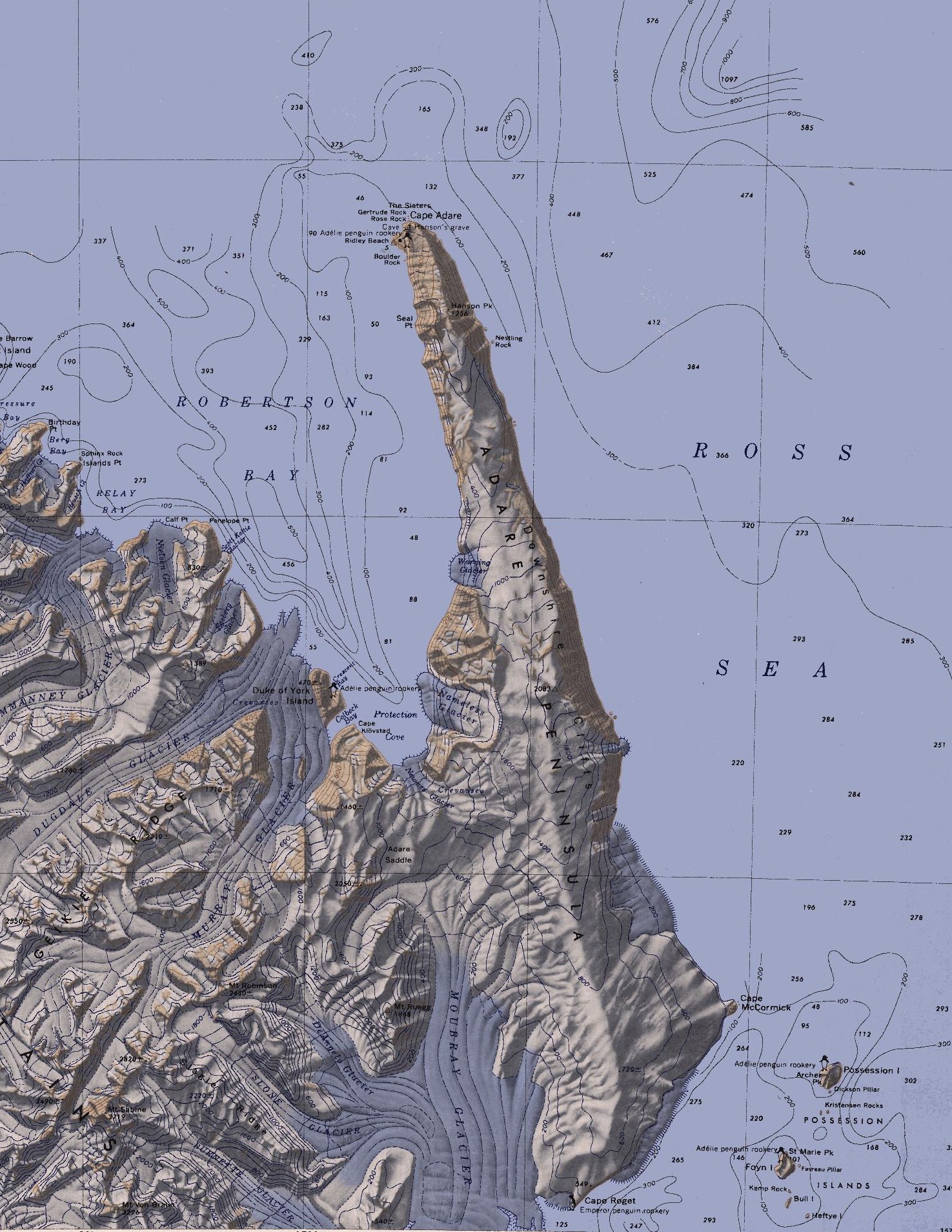
English: Map of the Adare Peninsula west of the Ross Sea. |
| Date | |
| Source | File:C71188s5 Ant.Map Cape Adare.jpg |
| Auteur | U. S. Geological Survey |
Conditions d’utilisation
Cette image est placée dans le domaine public parce qu'elle contient des éléments issus de l'United States Geological Survey, une agence du Département de l'Intérieur des États-Unis. Pour plus d'information, consultez la politique officielle de copyright de l'USGS (en anglais)
|
Historique du fichier
Cliquer sur une date et heure pour voir le fichier tel qu'il était à ce moment-là.
| Date et heure | Vignette | Dimensions | Utilisateur | Commentaire | |
|---|---|---|---|---|---|
| actuel | 11 mars 2010 à 23:51 | | 1 475 × 1 908 (769 kio) | 4ing | == {{int:filedesc}} == {{Information |Description={{en|1=Map of Possession Islands in the Ross Sea.}} |Source=File:C71188s5 Ant.Map Cape Adare.jpg |Author=U. S. Geological Survey |Date=1968 |Permission= |other_versions= }} <!--{{ImageUpload|basic}}- |
Utilisation du fichier
La page suivante utilise ce fichier :
Usage global du fichier
Les autres wikis suivants utilisent ce fichier :
- Utilisation sur be.wikipedia.org
- Utilisation sur ceb.wikipedia.org
- Utilisation sur da.wikipedia.org
- Utilisation sur de.wikipedia.org
- Transantarktisches Gebirge
- Kap Adare
- Adare-Halbinsel
- Kap Roget
- Robertson Bay
- Adare Saddle
- Newnes-Gletscher
- Moubray-Gletscher
- Protection Cove
- Colbeck Bay
- Herzog-von-York-Insel
- Murray-Gletscher
- Dugdale-Gletscher
- Geikie Ridge
- Archer Peak
- Possession Island (Antarktika)
- Possession Islands
- Kap McCormick
- Berg Bay
- Burnette-Gletscher
- Boulder Rock
- Ridley Beach
- Bull Island (Antarktika)
- Kemp Rock
- Heftye Island
- Foyn Island
- Crescent Bay
- DeAngelo-Gletscher
- Mount Robinson (Viktorialand)
- Mount Ruegg
- Dickson Pillar
- Downshire-Kliffs
- Favreau Pillar
- Gertrude Rock
- Rose Rock
- Hanson Peak
- Hargreaves Peak
- Nameless Glacier
- Kristensen Rocks
- Nestling Rock
- Seal Point (Viktorialand)
Voir davantage sur l’utilisation globale de ce fichier.