Fichier:Administrative map of Romania, 1952-1956.png

Taille de cet aperçu : 800 × 572 pixels. Autres résolutions : 320 × 229 pixels | 640 × 458 pixels | 1 024 × 732 pixels | 1 400 × 1 001 pixels.
Fichier d’origine (1 400 × 1 001 pixels, taille du fichier : 338 kio, type MIME : image/png)
Ce fichier et sa description proviennent de Wikimedia Commons.
| Description |
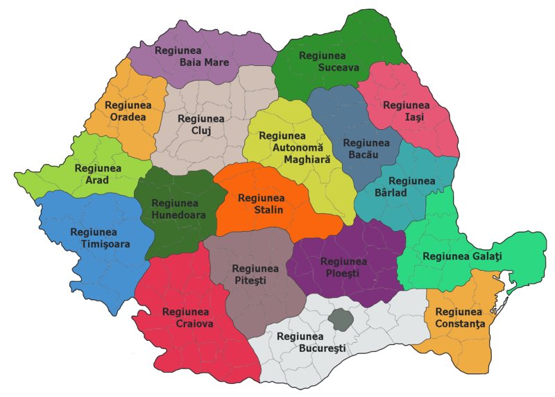
Administrative map of Romania, 1952-1956
|
| Source |
La page de description originale était ici. Tous les noms d'utilisateur qui suivent se rapportent à ro.wikipedia. |
| Auteur | ro:user:Radufan |
| Cette œuvre a été placée dans le domaine public par son auteur, Radufan. Ceci s’applique dans le monde entier. Dans certains pays, ceci peut ne pas être possible ; dans ce cas : |
Journal des téléversements d’origine
La page de description originale était ici. Tous les noms d'utilisateur qui suivent se rapportent à ro.wikipedia.
| Upload date | User | Bytes | Dimensions | Comment |
|---|---|---|---|---|
| 2006-10-02 00:26:09 | Radufan | 346530 | 1400×1001 | Impartirea Administrativ-teritoriala a Romaniei la 1953 |
Historique du fichier
Cliquer sur une date et heure pour voir le fichier tel qu'il était à ce moment-là.
| Date et heure | Vignette | Dimensions | Utilisateur | Commentaire | |
|---|---|---|---|---|---|
| actuel | 6 février 2010 à 14:29 | | 1 400 × 1 001 (338 kio) | Alex:D | {{Information |Description=Administrative map of Romania, 1952-1956 *Bucharest had a special status of "town subordinated to the Republic" *Each region bears the name of the capital city, except: **Autonomous Hungarian Region — Târgu Mureş **Hunedoara |
Utilisation du fichier
Les 2 pages suivantes utilisent ce fichier :
Usage global du fichier
Les autres wikis suivants utilisent ce fichier :
- Utilisation sur da.wikipedia.org
- Utilisation sur en.wikipedia.org
- Utilisation sur es.wikipedia.org
- Utilisation sur hu.wikipedia.org
- Utilisation sur it.wikipedia.org
- Utilisation sur nl.wikipedia.org
- Utilisation sur ro.wikipedia.org
- Județul Teleorman
- Regiunea Autonomă Maghiară
- Utilizator:Radufan
- Regiunea Timișoara
- Republica Populară Română
- Format:RegiuniRPR
- Regiunea Arad
- Regiunea Cluj
- Regiunea Stalin
- Regiunea Hunedoara
- Organizarea teritorială a Republicii Populare Române
- Regiunea Craiova
- Regiunea Ploiești
- Regiunea Pitești
- Regiunea Oradea
- Regiunea Baia Mare
- Regiunea București
- Regiunea Constanța
- Regiunea Galați
- Regiunea Bacău
- Regiunea Iași
- Regiunea Suceava
- Regiunea Bihor
- Regiunea Bârlad
- Diviziunile administrative istorice ale României
- Utilisation sur ru.wikipedia.org