Fichier:Alexander archipelago.jpg

Taille de cet aperçu : 450 × 600 pixels. Autres résolutions : 180 × 240 pixels | 360 × 480 pixels | 576 × 768 pixels | 1 050 × 1 400 pixels.
Fichier d’origine (1 050 × 1 400 pixels, taille du fichier : 529 kio, type MIME : image/jpeg)
Ce fichier et sa description proviennent de Wikimedia Commons.
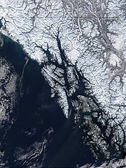
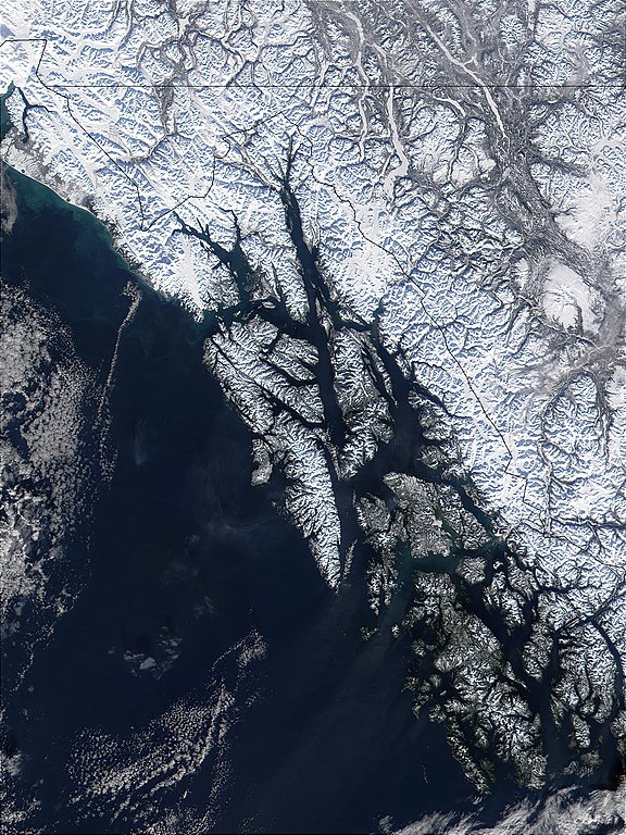
| Description | West of British Columbia, Canada, and south of the Yukon Territory, the southeastern coastline of Alaska trails off into the islands of the Alexander Archipelago. The area is rugged and contains many long, U-shaped, glaciated valleys, many of which terminate at tidewater. The Alexander Archipelago is home to Glacier Bay National Park. The large bay that has two forks on its northern end is Glacier Bay itself. The eastern fork is Muir inlet, into which runs the Muir glacier, named for the famous Scottish-born naturalist John Muir. Glacier Bay opens up into the Icy Strait. The large, solid white area to the west is Brady Icefield, which terminates at the southern end in Brady's Glacier. |
| Date | |
| Source | https://visibleearth.nasa.gov/images/57719/alexander-archipelago-southeastern-alaska |
| Auteur | Jacques Descloitres, MODIS Land Rapid Response Team, NASA/GSFC |
| Ce fichier provient de la NASA. Sauf exception, les documents créés par la NASA ne sont pas soumis à copyright. Pour plus d'informations, voir la politique de copyright de la NASA. | ||
 |
Attention :
|
Historique du fichier
Cliquer sur une date et heure pour voir le fichier tel qu'il était à ce moment-là.
| Date et heure | Vignette | Dimensions | Utilisateur | Commentaire | |
|---|---|---|---|---|---|
| actuel | 1 juin 2005 à 11:32 | | 1 050 × 1 400 (529 kio) | Alib | NASA MODIS satellite image of the Alexander archipelago, Alaska |
Utilisation du fichier
La page suivante utilise ce fichier :
Usage global du fichier
Les autres wikis suivants utilisent ce fichier :
- Utilisation sur ar.wikipedia.org
- Utilisation sur arz.wikipedia.org
- Utilisation sur ast.wikipedia.org
- Utilisation sur az.wikipedia.org
- Utilisation sur be.wikipedia.org
- Utilisation sur ca.wikipedia.org
- Utilisation sur ceb.wikipedia.org
- Utilisation sur cs.wikipedia.org
- Utilisation sur da.wikipedia.org
- Utilisation sur de.wikipedia.org
- Utilisation sur en.wikipedia.org
- Utilisation sur en.wikivoyage.org
- Utilisation sur eo.wikipedia.org
- Utilisation sur es.wikipedia.org
- Utilisation sur et.wikipedia.org
- Utilisation sur eu.wikipedia.org
- Utilisation sur fa.wikipedia.org
- Utilisation sur fi.wikipedia.org
- Utilisation sur fy.wikipedia.org
Voir davantage sur l’utilisation globale de ce fichier.