Fichier:Apalachicola National Forest (Apalachicola-Wakulla Ranger Districts), Florida LOC 82696340.tif

Taille de cet aperçu JPG pour ce fichier TIF : 717 × 599 pixels. Autres résolutions : 287 × 240 pixels | 574 × 480 pixels | 919 × 768 pixels | 1 225 × 1 024 pixels | 2 451 × 2 048 pixels | 9 661 × 8 074 pixels.
Fichier d’origine (9 661 × 8 074 pixels, taille du fichier : 223,17 Mio, type MIME : image/tiff)
Ce fichier et sa description proviennent de Wikimedia Commons.
Description
| Description |
English: "Land status current as of September 1980." Relief shown by spot heights. Panel title: Apalachicola National Forest, Florida. "Forest Service map class A." "Revised at Reston, Virginia, and the Geometronics Service Center, Salt Lake City, Utah, using 1974 source material." "Tallahassee meridian." Includes notes, indexed table of recreation sites, index map of U.S.G.S. topographic coverage, location map, and col. ill. Available also through the Library of Congress Web site as a raster image. |
||
| Title | Apalachicola National Forest (Apalachicola-Wakulla Ranger Districts), Florida | ||
| Shelf ID | G3932.A7 1980 .U5 | ||
| Date | |||
| Source | https://www.loc.gov/item/82696340/ | ||
| Auteur | United States. Forest Service. Southern Region | ||
| Autorisation (Réutilisation de ce fichier) |
|
||
| Autres versions |
|
||
| Location | United States · Apalachicola National Forest. · Florida · Apalachicola National Forest | ||
| Part of | American Memory · General Maps · Catalog · Geography And Map Division | ||
| Subject | United States · Maps · Apalachicola National Forest (Fla.) · Florida · Apalachicola National Forest |

,_Florida_LOC_82696340.jpg)
Conditions d’utilisation
Ce média est dans le domaine public des États-Unis d’Amérique car son auteur est l’administration américaine comme précisé dans le code fédéral au Titre 17, Chapitre 1, Section 105. Pour en savoir plus : droit d’auteur.
Attention : Ceci ne concerne que le travail du Gouvernement Fédéral et pas celui des États, ou d’une autre subdivision géographique ou politique du pays.
|
 | |
| Ce fichier a été identifié comme étant exempt de restrictions connues liées au droit d’auteur, y compris tous les droits connexes et voisins. | ||
Historique du fichier
Cliquer sur une date et heure pour voir le fichier tel qu'il était à ce moment-là.
| Date et heure | Vignette | Dimensions | Utilisateur | Commentaire | |
|---|---|---|---|---|---|
| actuel | 10 septembre 2018 à 17:18 | 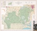 | 9 661 × 8 074 (223,17 Mio) | Fæ | LOC Maps https://www.loc.gov/item/82696340/ #19872 |
Utilisation du fichier
La page suivante utilise ce fichier :