Fichier:Approximate extension of Alodia based on accounts of Ibn Hawqal.png

Taille de cet aperçu : 800 × 581 pixels. Autres résolutions : 320 × 232 pixels | 640 × 464 pixels | 813 × 590 pixels.
Fichier d’origine (813 × 590 pixels, taille du fichier : 106 kio, type MIME : image/png)
Ce fichier et sa description proviennent de Wikimedia Commons.
Description
| Description |
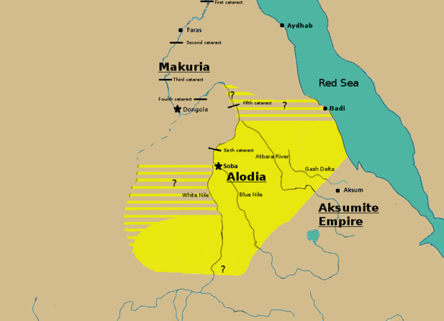
English: Initially based on map IX from the book "The Kingdom of Alwa" (see the first four versions of the map to see the faithful copy).[1] The original map had several problems, so I decided to modify it. 1) Zarroug had Alodia extend as far west as Darfur. However, there is still virtually no archaeological evidence supporting this assumption.[2] 2) The exact nothern border is still desputed; it is generally placed between Abu Hamad and the confluence of the Nile and the Atbara.[3] 3) Zarroug shows all regions west of the Nile as part of Alodia. However, the traveller Ibn Hawqal explicitly stated that parts of the region west of the White Nile were part of Makuria. The Nuba mountains were probably part of Alodia, hence I included stripes and a question mark for the area between the confluence of the two Niles and the Nuba mountains.[4] 4) There is little evidence that the Bayuda desert (between ed Debba and Omdurman) was part of either Makuria or Alodia.[5]
|
| Date | |
| Source | Travail personnel |
| Auteur | LeGabrie |
Conditions d’utilisation
Moi, en tant que détenteur des droits d’auteur sur cette œuvre, je la publie sous la licence suivante :
Ce fichier est sous la licence Creative Commons Attribution – Partage dans les Mêmes Conditions 4.0 International.
- Vous êtes libre :
- de partager – de copier, distribuer et transmettre cette œuvre
- d’adapter – de modifier cette œuvre
- Sous les conditions suivantes :
- paternité – Vous devez donner les informations appropriées concernant l'auteur, fournir un lien vers la licence et indiquer si des modifications ont été faites. Vous pouvez faire cela par tout moyen raisonnable, mais en aucune façon suggérant que l’auteur vous soutient ou approuve l’utilisation que vous en faites.
- partage à l’identique – Si vous modifiez, transformez, ou vous basez sur cette œuvre, vous devez distribuer votre contribution sous la même licence ou une licence compatible avec celle de l’original.
Historique du fichier
Cliquer sur une date et heure pour voir le fichier tel qu'il était à ce moment-là.
| Date et heure | Vignette | Dimensions | Utilisateur | Commentaire | |
|---|---|---|---|---|---|
| actuel | 27 novembre 2018 à 17:20 | | 813 × 590 (106 kio) | LeGabrie | Deleted stripes in Bayuda desert |
| 28 octobre 2018 à 17:47 |  | 703 × 590 (114 kio) | LeGabrie | decreased width | |
| 15 octobre 2018 à 14:51 |  | 813 × 590 (108 kio) | LeGabrie | Added Gash Delta | |
| 29 septembre 2018 à 13:38 |  | 813 × 590 (108 kio) | LeGabrie | Extended the beams over the entire Bayuda | |
| 4 septembre 2018 à 14:12 |  | 813 × 590 (111 kio) | LeGabrie | added question mark | |
| 4 septembre 2018 à 13:59 |  | 813 × 590 (108 kio) | LeGabrie | Cut the beams in Darfur | |
| 1 septembre 2018 à 02:55 |  | 813 × 590 (114 kio) | LeGabrie | Increased script size | |
| 1 septembre 2018 à 02:51 |  | 813 × 590 (114 kio) | LeGabrie | small fix | |
| 1 septembre 2018 à 02:49 |  | 813 × 590 (114 kio) | LeGabrie | Made it prettier | |
| 1 février 2018 à 23:14 |  | 813 × 590 (155 kio) | LeGabrie | Added white beams and question marks to highlight the uncertainties of Zarroug's map. These uncertainties are: The extension into Darfur,the question of ownership of northern Kordofan and the beginning of Al-Abwab. The concrete amount of desert aside o... |
Utilisation du fichier
Les 3 pages suivantes utilisent ce fichier :
Usage global du fichier
Les autres wikis suivants utilisent ce fichier :
- Utilisation sur ar.wikipedia.org
- Utilisation sur arz.wikipedia.org
- Utilisation sur azb.wikipedia.org
- Utilisation sur cs.wikipedia.org
- Utilisation sur de.wikipedia.org
- Utilisation sur en.wikipedia.org
- Utilisation sur fa.wikipedia.org
- Utilisation sur fi.wikipedia.org
- Utilisation sur id.wikipedia.org
- Utilisation sur ms.wikipedia.org
- Utilisation sur nl.wikipedia.org
- Utilisation sur pt.wikipedia.org
- Utilisation sur ru.wikipedia.org
- Utilisation sur sl.wikipedia.org
- Utilisation sur sr.wikipedia.org
- Utilisation sur sv.wikipedia.org
- Utilisation sur ta.wikipedia.org
- Utilisation sur th.wikipedia.org
- Utilisation sur tl.wikipedia.org
- Utilisation sur uk.wikipedia.org
- Utilisation sur vi.wikipedia.org
- Utilisation sur zh.wikipedia.org