Fichier:Barnes Ice Cap, Baffin Island, Canada.jpg

Taille de cet aperçu : 336 × 599 pixels. Autres résolutions : 134 × 240 pixels | 269 × 480 pixels | 430 × 768 pixels | 574 × 1 024 pixels | 2 243 × 4 000 pixels.
Fichier d’origine (2 243 × 4 000 pixels, taille du fichier : 4,55 Mio, type MIME : image/jpeg)
Ce fichier et sa description proviennent de Wikimedia Commons.
Description
| Description |
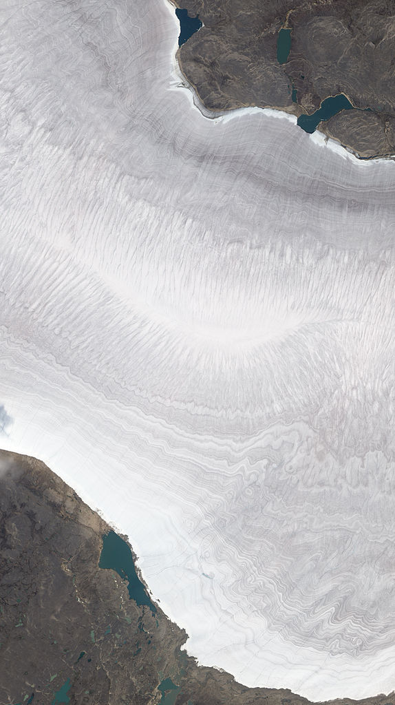
English: Natural-colour image of the Barnes Ice Cap, a bowling-pin-shaped glacier on Canada’s Baffin Island. The image shows a portion of the Barnes Ice Cap near its south-eastern end. Gee Lake sits immediately off the glacier. Resembling growth lines on a clamshell, striations run roughly east-west on the glacier surface. Rather than appearing pristine white, the ice and snow is banded with dust layers spanning time periods that dwarf a human life. By studying ice cores containing such dust layers, climatologists can find clues to ancient climates.
Ted Scambos of the National Snow and Ice Data Center observes that although the ice cap is essentially flat, it appears to undulate, thanks to ridges cut by melt streams running off the glacier. In this summertime shot, the glacier is mostly snow-free except for a band of snow along the edge near Gee Lake. As winter returns, snow will once again cover the glacier, the surrounding land, and the lake. |
| Date | |
| Source | NASA Earth Observatory |
| Auteur | Jesse Allen and Robert Simmon |
| Autres versions |
|

Image captured by The Advanced Land Imager (ALI) on NASA’s Earth Observing-1 (EO-1) satellite. EO-1 ALI data provided courtesy of the NASA EO-1 team.
Conditions d’utilisation
| Ce fichier provient de la NASA. Sauf exception, les documents créés par la NASA ne sont pas soumis à copyright. Pour plus d'informations, voir la politique de copyright de la NASA. | ||
 |
Attention :
|
| Annotations | Cette image est annotée : Voir les annotations sur Wikimedia Commons |
Historique du fichier
Cliquer sur une date et heure pour voir le fichier tel qu'il était à ce moment-là.
| Date et heure | Vignette | Dimensions | Utilisateur | Commentaire | |
|---|---|---|---|---|---|
| actuel | 11 octobre 2010 à 12:30 | | 2 243 × 4 000 (4,55 Mio) | Originalwana | {{Information |Description={{en|1=Natural-colour image of the Barnes Ice Cap, a bowling-pin-shaped glacier on Canada’s Baffin Island. The image shows a portion of the Barnes Ice Cap near its south-eastern end. Gee Lake sits immediately off the glaci |
Utilisation du fichier
La page suivante utilise ce fichier :
Usage global du fichier
Les autres wikis suivants utilisent ce fichier :
- Utilisation sur de.wikipedia.org
- Utilisation sur en.wikipedia.org
- Utilisation sur fi.wikipedia.org