Fichier:Beginning Point of the U.S. Public Land Survey front.jpg

Taille de cet aperçu : 450 × 600 pixels. Autres résolutions : 180 × 240 pixels | 360 × 480 pixels | 576 × 768 pixels | 768 × 1 024 pixels | 2 112 × 2 816 pixels.
Fichier d’origine (2 112 × 2 816 pixels, taille du fichier : 3,37 Mio, type MIME : image/jpeg)
Ce fichier et sa description proviennent de Wikimedia Commons.
|
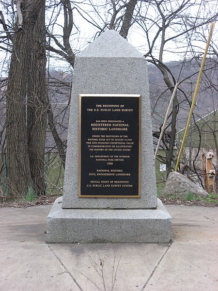
Ceci est une photographie d’un monument référencé dans le National Register of Historic Places des États-Unis sous le numéro 66000606. |
| Lieu de la prise de vue | | Voir cet endroit et d’autres images sur : OpenStreetMap |
|---|
| Description | Streetside view of the Beginning Point of the U.S. Public Land Survey, a monument marking the site that served as the basis for the entire Public Land Survey System — the system by which most of the United States, outside of the original colonies, was surveyed. Located on the Ohio/Pennsylvania border east of downtown East Liverpool, Ohio, it is split between the city of East Liverpool and the borough of Ohioville in Beaver County, Pennsylvania. Erected in 1881 by a joint commission of Ohio and Pennsylvania surveyors, the monument was declared a National Historic Landmark in 1966. The road on which it lies is Ohio State Route 39 and Pennsylvania Route 68. | ||
| Date | Prise le 28 mars 2009 | ||
| Source | Travail personnel | ||
| Auteur | User:Nyttend | ||
| Autorisation (Réutilisation de ce fichier) |
|
||
| Autres versions |
 Ohio and Ohio and  Pennsylvania sides of the monument Pennsylvania sides of the monument |
Historique du fichier
Cliquer sur une date et heure pour voir le fichier tel qu'il était à ce moment-là.
| Date et heure | Vignette | Dimensions | Utilisateur | Commentaire | |
|---|---|---|---|---|---|
| actuel | 28 mars 2009 à 06:29 | | 2 112 × 2 816 (3,37 Mio) | Nyttend | {{Location|40|38|33|N|80|31|10|W}} {{Information |Description=Streetside view of the {{w|Beginning Point of the U.S. Public Land Survey}}, a monument marking the site that served as the basis for the entire {{w|Public Land Survey System}} — the system b |
Utilisation du fichier
Les 2 pages suivantes utilisent ce fichier :
Usage global du fichier
Les autres wikis suivants utilisent ce fichier :
- Utilisation sur ca.wikipedia.org
- Utilisation sur de.wikipedia.org
- Utilisation sur en.wikipedia.org
- Public Land Survey System
- List of Historic Civil Engineering Landmarks
- Point of beginning
- List of National Historic Landmarks in Pennsylvania
- List of National Historic Landmarks in Ohio
- Beginning Point of the U.S. Public Land Survey
- National Register of Historic Places listings in Columbiana County, Ohio
- National Register of Historic Places listings in Beaver County, Pennsylvania
- List of Pennsylvania state historical markers in Beaver County
- User talk:Dthomsen8/List PA Test
- Utilisation sur en.wikivoyage.org
- Utilisation sur es.wikipedia.org
- Utilisation sur hu.wikipedia.org
- Utilisation sur it.wikipedia.org
- Utilisation sur ja.wikipedia.org
- Utilisation sur pt.wikipedia.org
- Utilisation sur tl.wikipedia.org
- Utilisation sur ur.wikipedia.org
- Utilisation sur vi.wikipedia.org
- Utilisation sur www.wikidata.org