Fichier:Belgian Railway Line 54.png

Taille de cet aperçu : 800 × 566 pixels. Autres résolutions : 320 × 226 pixels | 640 × 453 pixels | 1 024 × 724 pixels | 1 280 × 905 pixels | 1 558 × 1 102 pixels.
Fichier d’origine (1 558 × 1 102 pixels, taille du fichier : 2,19 Mio, type MIME : image/png)
Ce fichier et sa description proviennent de Wikimedia Commons.
Description
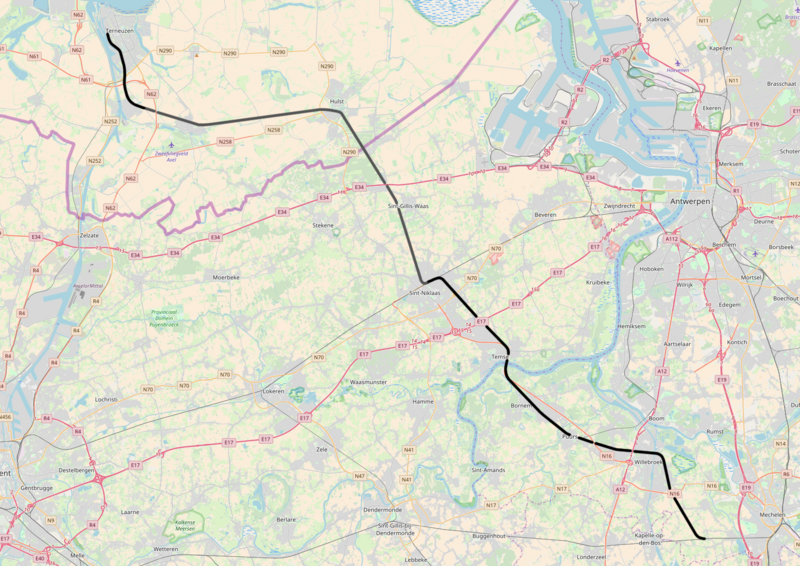
| Description | Belgian Railway Line 54, Y Heike - Terneuzen |
| Date | |
| Source | Travail personnel |
| Auteur | OpenStreetMap contributors |
Conditions d’utilisation
Moi, en tant que détenteur des droits d’auteur sur cette œuvre, je la publie sous les licences suivantes :

|
Vous avez la permission de copier, distribuer et modifier ce document selon les termes de la GNU Free Documentation License version 1.2 ou toute version ultérieure publiée par la Free Software Foundation, sans sections inaltérables, sans texte de première page de couverture et sans texte de dernière page de couverture. Un exemplaire de la licence est inclus dans la section intitulée GNU Free Documentation License. |
Ce fichier est sous licence Creative Commons Attribution – Partage dans les Mêmes Conditions 3.0 (non transposée), 2.5 Générique, 2.0 Générique et 1.0 Générique.
- Vous êtes libre :
- de partager – de copier, distribuer et transmettre cette œuvre
- d’adapter – de modifier cette œuvre
- Sous les conditions suivantes :
- paternité – Vous devez donner les informations appropriées concernant l'auteur, fournir un lien vers la licence et indiquer si des modifications ont été faites. Vous pouvez faire cela par tout moyen raisonnable, mais en aucune façon suggérant que l’auteur vous soutient ou approuve l’utilisation que vous en faites.
- partage à l’identique – Si vous modifiez, transformez, ou vous basez sur cette œuvre, vous devez distribuer votre contribution sous la même licence ou une licence compatible avec celle de l’original.
Vous pouvez choisir l’une de ces licences.
Historique du fichier
Cliquer sur une date et heure pour voir le fichier tel qu'il était à ce moment-là.
| Date et heure | Vignette | Dimensions | Utilisateur | Commentaire | |
|---|---|---|---|---|---|
| actuel | 26 novembre 2017 à 20:20 | | 1 558 × 1 102 (2,19 Mio) | Vunz | fix |
| 5 mai 2016 à 22:27 |  | 1 449 × 1 091 (2,31 Mio) | Vunz | greyed out former track | |
| 19 mai 2014 à 10:52 |  | 1 449 × 1 091 (2,31 Mio) | Vunz | improved | |
| 2 septembre 2010 à 17:27 |  | 1 133 × 709 (1,13 Mio) | Vunz | ||
| 8 décembre 2009 à 20:36 |  | 1 133 × 709 (1,13 Mio) | Vunz | == {{int:filedesc}} == {{Information |Description= spoorlijn 54, Y Heike - Terneuzen |Source= [http://openstreetmap.org openstreetmap.org]. |Date=2009-12-08 |Author= OpenStreetMap contributors |Permission= All OpenStreetMap data and maps are Creative Comm | |
| 24 janvier 2009 à 21:50 |  | 520 × 390 (35 kio) | Vunz | {{Information |Description={{nl|1=spoormap lijn 54}} |Source=eigen werk (own work) |Author=Wiebevl |Date=24/01/2009 |Permission= |other_versions= }} <!--{{ImageUpload|full}}--> Category:Rail transport maps of Belgium [[Category:Publi |
Utilisation du fichier
La page suivante utilise ce fichier :
Usage global du fichier
Les autres wikis suivants utilisent ce fichier :
- Utilisation sur en.wikipedia.org
- Utilisation sur nl.wikipedia.org
- Utilisation sur www.wikidata.org
- Utilisation sur zea.wikipedia.org