Fichier:Beryl May 27 2012 1835Z.jpg

Taille de cet aperçu : 466 × 599 pixels. Autres résolutions : 187 × 240 pixels | 373 × 480 pixels | 597 × 768 pixels | 796 × 1 024 pixels | 1 593 × 2 048 pixels | 5 600 × 7 200 pixels.
Fichier d’origine (5 600 × 7 200 pixels, taille du fichier : 31,04 Mio, type MIME : image/jpeg)
Ce fichier et sa description proviennent de Wikimedia Commons.
Description
| Description |
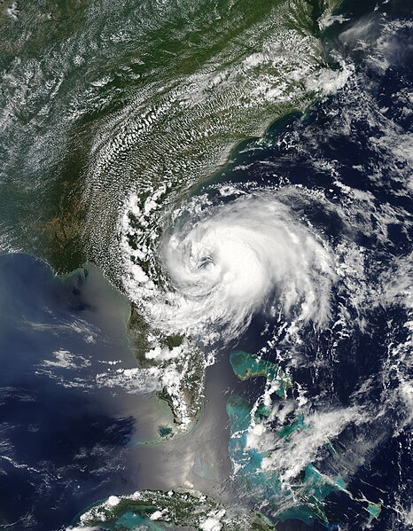
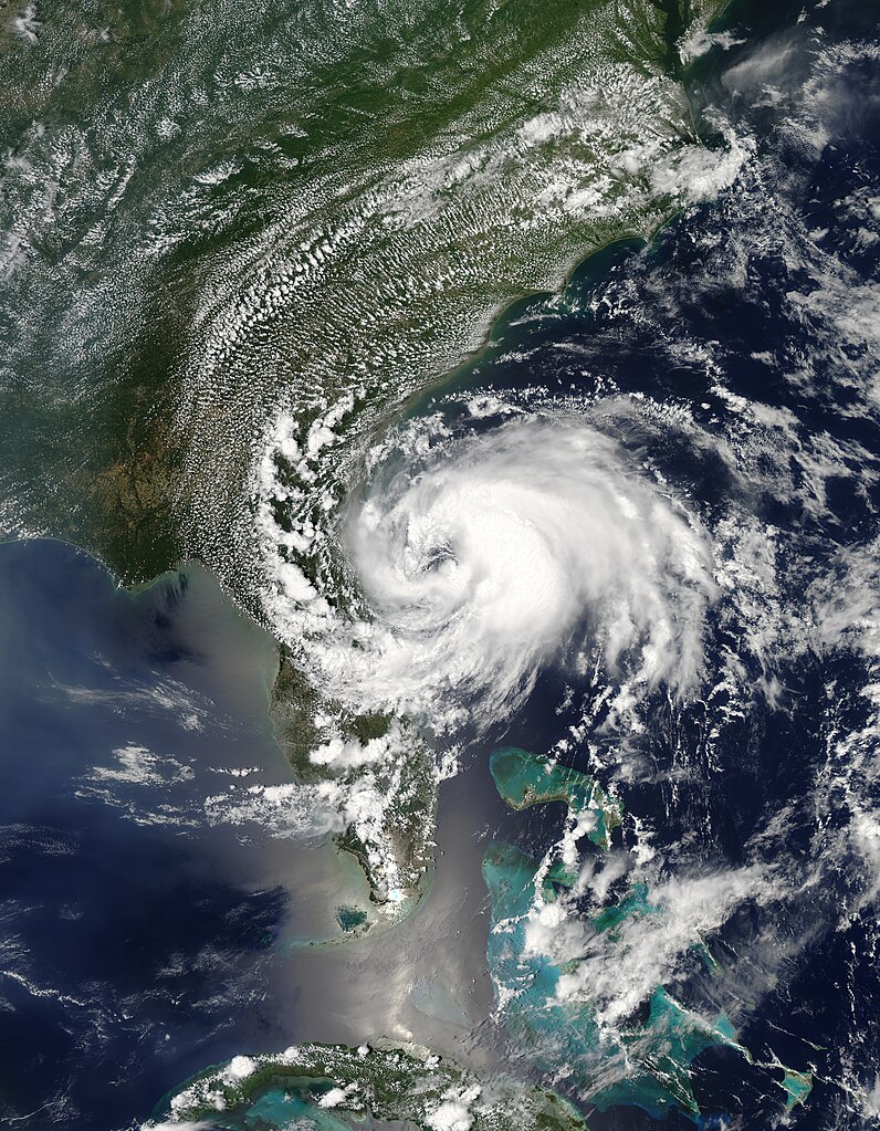
English: Beryl first formed as a subtropical storm over the Atlantic Ocean on May 25, 2012. The U.S. National Hurricane Center (NHC) tracked the storm’s progress, and at 2:00 p.m. Eastern Daylight Time (EDT) on May 27, the NHC announced that the storm was located roughly 110 miles (175 kilometers) east of Jacksonville, Florida. Having strengthened into a tropical storm, Beryl had maximum sustained winds of 65 miles (100 kilometers) per hour.
The Moderate Resolution Imaging Spectroradiometer (MODIS) on NASA’s Aqua satellite captured this natural-color image of Beryl on May 27, around 2:30 p.m. EDT. Beryl was making landfall along Florida’s east coast. The NHC warned that the hazards affecting land included high winds and flooding resulting from a combination of the storm surge and the tide. |
| Date | |
| Source | http://earthobservatory.nasa.gov/NaturalHazards/view.php?id=78120 |
| Auteur | NASA image courtesy Jeff Schmaltz, LANCE MODIS Rapid Response Team, Goddard Space Flight Center. Caption by Michon Scott |
Conditions d’utilisation
| Ce fichier provient de la NASA. Sauf exception, les documents créés par la NASA ne sont pas soumis à copyright. Pour plus d'informations, voir la politique de copyright de la NASA. | ||
 |
Attention :
|
Historique du fichier
Cliquer sur une date et heure pour voir le fichier tel qu'il était à ce moment-là.
| Date et heure | Vignette | Dimensions | Utilisateur | Commentaire | |
|---|---|---|---|---|---|
| actuel | 23 avril 2013 à 02:24 | | 5 600 × 7 200 (31,04 Mio) | Supportstorm | Better quality |
| 17 avril 2013 à 05:40 |  | 5 600 × 7 200 (9,72 Mio) | Earth100 | Please keep the official version. | |
| 24 novembre 2012 à 21:25 |  | 6 400 × 7 800 (43,77 Mio) | Supportstorm | HDF file quality | |
| 27 mai 2012 à 23:57 |  | 5 616 × 7 269 (11,19 Mio) | Supportstorm | {{Information |Description ={{en|1=Tropical Storm Beryl at near peak strength, hours before it makes landfall, on May 27, 2012.}} |Source =http://lance2.modaps.eosdis.nasa.gov/wms/usecase_all_devel.html?zoom=4&lat=31.22657&lon=-66.10546&laye... |
Utilisation du fichier
La page suivante utilise ce fichier :
Usage global du fichier
Les autres wikis suivants utilisent ce fichier :
- Utilisation sur de.wikipedia.org
- Utilisation sur en.wikipedia.org
- 2012 Atlantic hurricane season
- Timeline of the 2012 Atlantic hurricane season
- Tropical Storm Beryl (2012)
- Template:Did you know nominations/Tropical Storm Beryl (2012)
- Wikipedia:Recent additions/2012/June
- Wikipedia:Main Page history/2012 June 2
- User:ManhattanSandyFurystorm/sandbox
- User:CooperScience/TestingSandbox
- Utilisation sur es.wikipedia.org
- Utilisation sur ko.wikipedia.org
- Utilisation sur nl.wikipedia.org
- Utilisation sur pt.wikipedia.org
- Utilisation sur simple.wikipedia.org
- Utilisation sur zh.wikipedia.org