Fichier:California Congressional Districts, 113th Congress.tif

Taille de cet aperçu PNG pour ce fichier TIF : 612 × 599 pixels. Autres résolutions : 245 × 240 pixels | 490 × 480 pixels | 784 × 768 pixels | 1 045 × 1 024 pixels | 2 441 × 2 391 pixels.
Fichier d’origine (2 441 × 2 391 pixels, taille du fichier : 1,41 Mio, type MIME : image/tiff)
Ce fichier et sa description proviennent de Wikimedia Commons.
Description
| Description |
English: Map of Congressional Districts in the state of California, reflecting district boundaries current to the 113th United States Congress. |
| Date | |
| Source | National Atlas of the United States (http://nationalatlas.gov/printable/congress.html |
| Auteur | Department of the Interior |
| Autres versions | United States Census Bureau (https://www2.census.gov/geo/maps/cong_dist/uswall/cd116/CD116_US_WallMap.pdf) |
Conditions d’utilisation
This image or file is a work of a United States Census Bureau employee, taken or made as part of that person's official duties. As a work of the U.S. federal government, the image is in the public domain.
|
 |
Historique du fichier
Cliquer sur une date et heure pour voir le fichier tel qu'il était à ce moment-là.
| Date et heure | Vignette | Dimensions | Utilisateur | Commentaire | |
|---|---|---|---|---|---|
| actuel | 2 février 2014 à 08:00 | 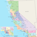 | 2 441 × 2 391 (1,41 Mio) | 7partparadigm | User created page with UploadWizard |
Utilisation du fichier
La page suivante utilise ce fichier :
Usage global du fichier
Les autres wikis suivants utilisent ce fichier :
- Utilisation sur en.wikipedia.org
- Utilisation sur fa.wikipedia.org
- Utilisation sur ru.wikipedia.org
- Utilisation sur tr.wikipedia.org
- Utilisation sur uk.wikipedia.org
- Utilisation sur zh.wikipedia.org