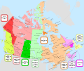
Fichier:Canada time zone map - fr.svg

Taille de cet aperçu PNG pour ce fichier SVG : 709 × 600 pixels. Autres résolutions : 284 × 240 pixels | 568 × 480 pixels | 908 × 768 pixels | 1 211 × 1 024 pixels | 2 422 × 2 048 pixels | 1 114 × 942 pixels.
Fichier d’origine (Fichier SVG, nominalement de 1 114 × 942 pixels, taille : 383 kio)
Historique du fichier
Cliquer sur une date et heure pour voir le fichier tel qu'il était à ce moment-là.
| Date et heure | Vignette | Dimensions | Utilisateur | Commentaire | |
|---|---|---|---|---|---|
| actuel | 31 octobre 2020 à 04:58 |  | 1 114 × 942 (383 kio) | MapGrid | Converted small area of fishing camps west of Suomi ON from CST/CDT to EST/EDT; this improves alignment with boundaries shown on the official Ontario road map. Also applied a few cosmetic changes. |
| 26 octobre 2020 à 00:35 |  | 1 114 × 942 (381 kio) | MapGrid | Time zone boundary adjustment in the vicinity of Schefferville. Time zone boundary adjustment on the Melville Peninsula. Many minor cosmetic changes. | |
| 25 septembre 2020 à 01:30 |  | 1 112 × 941 (317 kio) | MapGrid | Uploaded own work with UploadWizard |
Utilisation du fichier
La page suivante utilise ce fichier :


