Fichier:Canadian postal district map.svg

Taille de cet aperçu PNG pour ce fichier SVG : 709 × 600 pixels. Autres résolutions : 284 × 240 pixels | 567 × 480 pixels | 908 × 768 pixels | 1 210 × 1 024 pixels | 2 421 × 2 048 pixels | 1 000 × 846 pixels.
Fichier d’origine (Fichier SVG, nominalement de 1 000 × 846 pixels, taille : 237 kio)
Ce fichier et sa description proviennent de Wikimedia Commons.
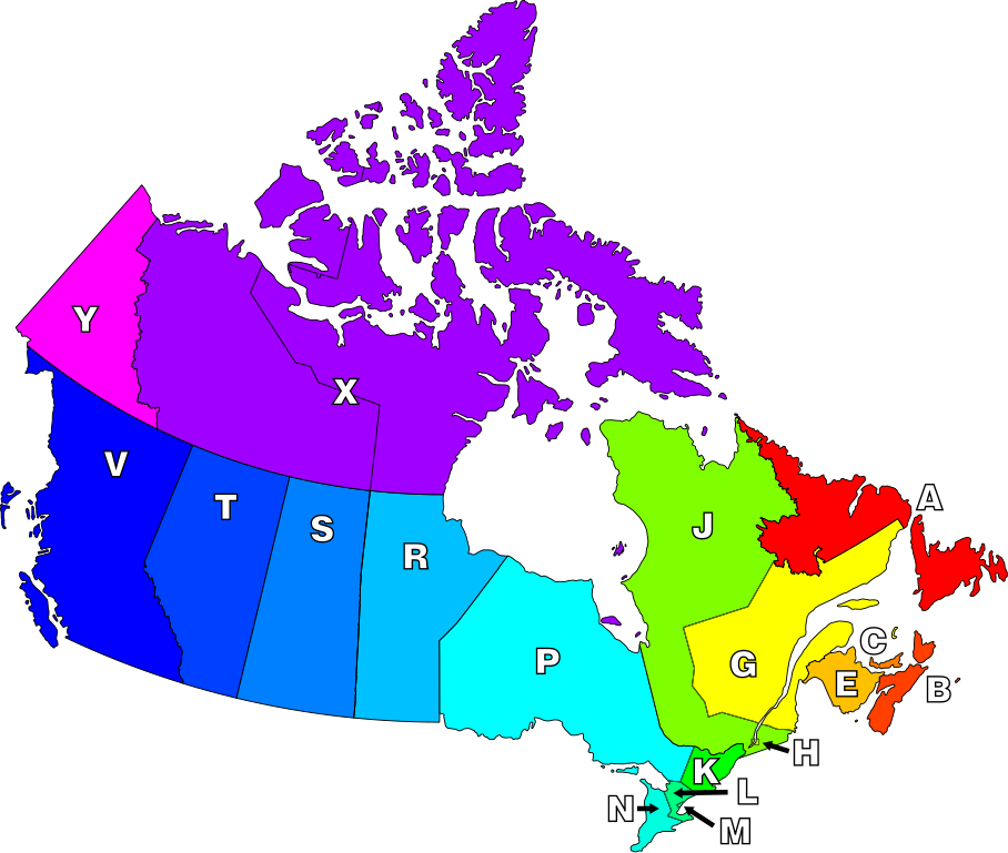
The definition of "postal district" is a geographical area in Canada where all postal codes start with the same letter.
| Description | Map of Canada highlighting postal districts. | ||
| Date | |||
| Source | Own work, based on National Atlas of Canada mapping. | ||
| Auteur | Denelson83 | ||
| Autorisation (Réutilisation de ce fichier) |
|
||
| Autres versions | Image:Canadian Postal Code Map.png |
Historique du fichier
Cliquer sur une date et heure pour voir le fichier tel qu'il était à ce moment-là.
| Date et heure | Vignette | Dimensions | Utilisateur | Commentaire | |
|---|---|---|---|---|---|
| actuel | 8 janvier 2007 à 09:21 | | 1 000 × 846 (237 kio) | Denelson83 | Round corners |
| 8 janvier 2007 à 09:18 |  | 1 000 × 846 (236 kio) | Denelson83 | The definition of "postal district" is a geographical area in Canada where all en:Canadian postal codes start with the same letter. {{Information |Description=Map of Canada highlighting postal districts. |Source=Own work, based on National Atlas of |
Utilisation du fichier
La page suivante utilise ce fichier :
Usage global du fichier
Les autres wikis suivants utilisent ce fichier :
- Utilisation sur csb.wikipedia.org
- Utilisation sur de.wikipedia.org
- Utilisation sur en.wikipedia.org
- Utilisation sur eo.wikipedia.org
- Utilisation sur id.wikipedia.org
- Utilisation sur nl.wikipedia.org
- Utilisation sur pl.wikipedia.org
- Utilisation sur ta.wikipedia.org