Fichier:Cheshunt, Theobalds - geograph.org.uk - 552741.jpg
Pas de plus haute résolution disponible.
Cheshunt,_Theobalds_-_geograph.org.uk_-_552741.jpg (640 × 480 pixels, taille du fichier : 121 kio, type MIME : image/jpeg)
Ce fichier et sa description proviennent de Wikimedia Commons.
Description
| Description |
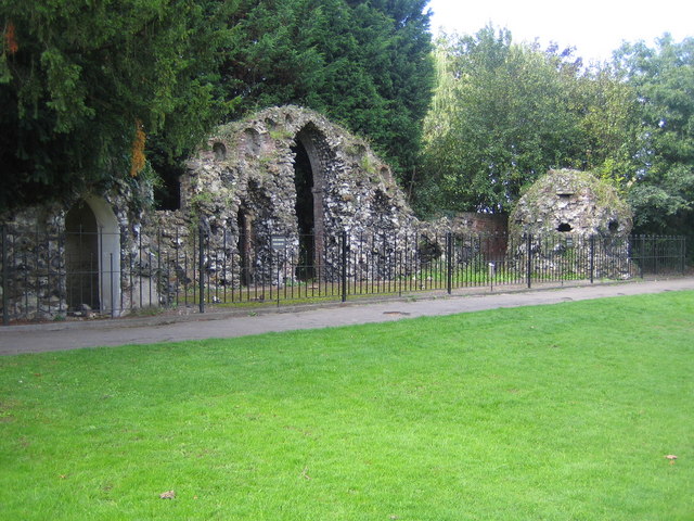
English: Cheshunt: Theobalds These walls and entranceways are one of the few ruins left of the former Theobalds Palace, built by William Cecil, Lord Burghley, in the 1560s. Queen Elizabeth I was a frequent visitor to the Palace. She was succeeded by King James I who stayed at Theobalds in 1603 as a guest of Lord Burghley's son, Robert Cecil, while on his way from Scotland to be crowned in London. King James was so taken with Theobalds that he exchanged it with the Cecils for Hatfield House in 1607. King James I died at Theobalds in 1625, and it remained a royal palace during the reign of King Charles I. However after the accession of Oliver Cromwell and the execution of Charles in 1649, Theobalds was razed to the ground by the Parliamentarians.
Today the remains can be found in Cedars Park. |
| Date | |
| Source | From geograph.org.uk |
| Auteur | Nigel Cox |
| Attribution (imposé par la licence) | Nigel Cox / Cheshunt: Theobalds / |
| Lieu de la prise de vue | | Voir cet endroit et d’autres images sur : OpenStreetMap |
|---|
_heading:225.00&language=fr)
| Position de l'objet | | Voir cet endroit et d’autres images sur : OpenStreetMap |
|---|
_heading:225.00&language=fr)
Conditions d’utilisation

|
Cette image provient de la collection du projet Geograph British Isles. Pour obtenir les coordonnées du photographe, veuillez consulter cette page de description de l'image sur le site du projet. Les droits d'auteurs sur cette image sont détenus par Nigel Cox ; l'image est placée sous une licence Creative Commons avec mention de paternité et partage à l'identique (CC-By-SA) en version 2.0.
|
Ce fichier est disponible selon les termes de la licence Creative Commons Attribution – Partage dans les Mêmes Conditions 2.0 Générique
Attribution: Nigel Cox
- Vous êtes libre :
- de partager – de copier, distribuer et transmettre cette œuvre
- d’adapter – de modifier cette œuvre
- Sous les conditions suivantes :
- paternité – Vous devez donner les informations appropriées concernant l'auteur, fournir un lien vers la licence et indiquer si des modifications ont été faites. Vous pouvez faire cela par tout moyen raisonnable, mais en aucune façon suggérant que l’auteur vous soutient ou approuve l’utilisation que vous en faites.
- partage à l’identique – Si vous modifiez, transformez, ou vous basez sur cette œuvre, vous devez distribuer votre contribution sous la même licence ou une licence compatible avec celle de l’original.
Historique du fichier
Cliquer sur une date et heure pour voir le fichier tel qu'il était à ce moment-là.
| Date et heure | Vignette | Dimensions | Utilisateur | Commentaire | |
|---|---|---|---|---|---|
| actuel | 6 février 2011 à 04:33 | | 640 × 480 (121 kio) | GeographBot | == {{int:filedesc}} == {{Information |description={{en|1=Cheshunt: Theobalds These walls and entranceways are one of the few ruins left of the former Theobalds Palace, built by William Cecil, Lord Burghley, in the 1560s. Queen Elizabeth I was a frequent v |
Utilisation du fichier
La page suivante utilise ce fichier :
Usage global du fichier
Les autres wikis suivants utilisent ce fichier :
- Utilisation sur en.wikipedia.org
- Utilisation sur www.wikidata.org