Fichier:Chios topographic map-fr.svg

Taille de cet aperçu PNG pour ce fichier SVG : 800 × 582 pixels. Autres résolutions : 320 × 233 pixels | 640 × 466 pixels | 1 024 × 745 pixels | 1 280 × 932 pixels | 2 560 × 1 863 pixels | 1 580 × 1 150 pixels.
Fichier d’origine (Fichier SVG, nominalement de 1 580 × 1 150 pixels, taille : 1,35 Mio)
Ce fichier et sa description proviennent de Wikimedia Commons.
Description
| Lieu de la prise de vue | | Voir cet endroit et d’autres images sur : OpenStreetMap |
|---|
| Description |
[]
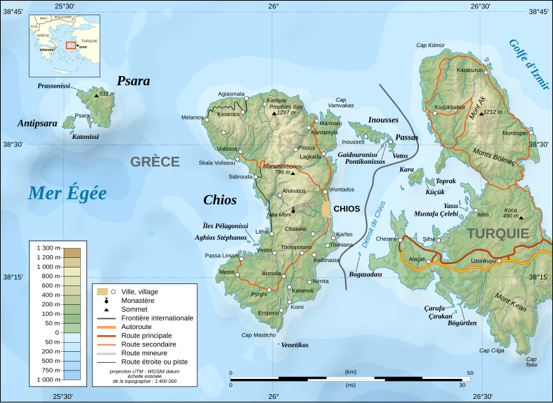
English: Note: The shaded relief is a raster image embedded in the SVG file.
Français : Note : Les ombre du relief sont une image bitmap embarquée dans le fichier SVG.
UTM projection ; WGS84 datum ; shaded relief (composite image of N-W, W and N lightning positions) ;
|
||
| Date | November 2007 (modified august 2008) | ||
| Source |
Own work ;
|
||
| Auteur | Eric Gaba (Sting - fr:Sting) | ||
| Autorisation (Réutilisation de ce fichier) |
|
||
| Autres versions |
[]
|


|
Ce fichier SVG contient du texte encapsulé pouvant facilement être traduit dans votre langue en utilisant n'importe quel éditeur de fichier SVG ou de texte, ou par l'outil de traduction de fichiers SVG. Pour plus d'informations, voir : A propos de la traduction des fichiers SVG. |
Conditions d’utilisation
Moi, en tant que détenteur des droits d’auteur sur cette œuvre, je la publie sous les licences suivantes :

|
Vous avez la permission de copier, distribuer et modifier ce document selon les termes de la GNU Free Documentation License version 1.2 ou toute version ultérieure publiée par la Free Software Foundation, sans sections inaltérables, sans texte de première page de couverture et sans texte de dernière page de couverture. Un exemplaire de la licence est inclus dans la section intitulée GNU Free Documentation License. |
This file is licensed under the Creative Commons Attribution-Share Alike Attribution-Share Alike 4.0 International, 3.0 Unported, 2.5 Generic, 2.0 Generic and 1.0 Generic license.
- Vous êtes libre :
- de partager – de copier, distribuer et transmettre cette œuvre
- d’adapter – de modifier cette œuvre
- Sous les conditions suivantes :
- paternité – Vous devez donner les informations appropriées concernant l'auteur, fournir un lien vers la licence et indiquer si des modifications ont été faites. Vous pouvez faire cela par tout moyen raisonnable, mais en aucune façon suggérant que l’auteur vous soutient ou approuve l’utilisation que vous en faites.
- partage à l’identique – Si vous modifiez, transformez, ou vous basez sur cette œuvre, vous devez distribuer votre contribution sous la même licence ou une licence compatible avec celle de l’original.
Vous pouvez choisir l’une de ces licences.
Historique du fichier
Cliquer sur une date et heure pour voir le fichier tel qu'il était à ce moment-là.
| Date et heure | Vignette | Dimensions | Utilisateur | Commentaire | |
|---|---|---|---|---|---|
| actuel | 27 janvier 2022 à 19:26 | | 1 580 × 1 150 (1,35 Mio) | Pinacotecus | Reverted to version as of 04:38, 1 September 2008 (UTC) |
| 27 janvier 2022 à 18:39 |  | 1 580 × 1 150 (1,4 Mio) | Pinacotecus | File uploaded using svgtranslate tool (https://svgtranslate.toolforge.org/). Added translation for en. | |
| 27 janvier 2022 à 18:23 |  | 1 580 × 1 150 (1,4 Mio) | Pinacotecus | File uploaded using svgtranslate tool (https://svgtranslate.toolforge.org/). Added translation for en. | |
| 1 septembre 2008 à 06:38 |  | 1 580 × 1 150 (1,35 Mio) | Sting | New bathymetry from NGDC ETOPO1 ; new standard colors | |
| 29 novembre 2007 à 01:44 |  | 1 580 × 1 150 (1,18 Mio) | Sting | {{Information |Description=Topographic map in French of Chios and Psara islands, Aegean Sea, Greece |Source=Own work ;<br/>Topography : [http://www2.jpl.nasa.gov/srtm NASA Shuttle Radar Top |
Utilisation du fichier
Les 5 pages suivantes utilisent ce fichier :
Usage global du fichier
Les autres wikis suivants utilisent ce fichier :
- Utilisation sur el.wikipedia.org
- Utilisation sur fr.wiktionary.org
- Utilisation sur hu.wikipedia.org
- Utilisation sur ia.wikipedia.org
- Utilisation sur it.wikipedia.org
- Utilisation sur ku.wikipedia.org
- Utilisation sur no.wikipedia.org
- Utilisation sur pt.wikipedia.org
- Utilisation sur ru.wikipedia.org
- Utilisation sur sr.wikipedia.org
- Utilisation sur tr.wikipedia.org
- Utilisation sur uk.wikipedia.org
- Utilisation sur war.wikipedia.org