Fichier:CraterHighlands Tanzania NASA.jpg
Taille de cet aperçu : 484 × 600 pixels. Autres résolutions : 194 × 240 pixels | 540 × 669 pixels.
Fichier d’origine (540 × 669 pixels, taille du fichier : 118 kio, type MIME : image/jpeg)
Ce fichier et sa description proviennent de Wikimedia Commons.
Description
| Description |
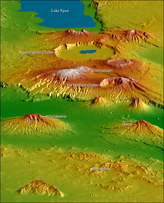
English: Topographical map of the w:Crater Highlands in Tanzania. Color indicates height, with lowest elevations in green and highest elevations in white. Shading shows the slope. The vertical relief has been exaggerated by a factor of 2 to reveal greater detail about the landscape. The image is oriented as though you were looking from the north toward the southwest.
Afrikaans: Topografiese kaart van Tanzanië se kraterhooglande. Kleur dui hoogte aan, met laagste gebiede in groen en hoogste hoogtes in wit. Skadu dui hellings aan, en die vertikale reliëf is verdubbel om meer landskapdetail weer te gee. Die uitsig is georiënteer van die noordooste na suidweste. Natronmeer is net buite sig aan regterhand. |
| Date | |
| Source | https://earthobservatory.nasa.gov/IOTD/view.php?id=6316 |
| Auteur | Robert E. Crippen, NASA/JPL Shuttle Radar Topography Mission team. Labels by NASA Earth Observatory newsroom. |
| Autorisation (Réutilisation de ce fichier) |
US government, public domain. |
| Autres versions |
Œuvres dérivées de ce fichier : CraterHighlands Tanzania NASA unannotated.jpg Larger, unannotated version available at source URL. |
Conditions d’utilisation
| Ce fichier provient de la NASA. Sauf exception, les documents créés par la NASA ne sont pas soumis à copyright. Pour plus d'informations, voir la politique de copyright de la NASA. | ||
 |
Attention :
|
Historique du fichier
Cliquer sur une date et heure pour voir le fichier tel qu'il était à ce moment-là.
| Date et heure | Vignette | Dimensions | Utilisateur | Commentaire | |
|---|---|---|---|---|---|
| actuel | 28 avril 2006 à 19:53 | | 540 × 669 (118 kio) | Holly Cheng | {{Information | Description=Topographical map of the w:Crater Highlands in Tanzania. Color indicates height, with lowest elevations in green and highest elevations in white. Shading shows the slope. The vertical relief has been exaggerated by a factor |
Utilisation du fichier
Les 3 pages suivantes utilisent ce fichier :
Usage global du fichier
Les autres wikis suivants utilisent ce fichier :
- Utilisation sur arz.wikipedia.org
- Utilisation sur avk.wikipedia.org
- Utilisation sur ceb.wikipedia.org
- Utilisation sur de.wikipedia.org
- Utilisation sur el.wikipedia.org
- Utilisation sur en.wikipedia.org
- Utilisation sur es.wikipedia.org
- Utilisation sur he.wikipedia.org
- Utilisation sur hr.wikipedia.org
- Utilisation sur ru.wikipedia.org
- Utilisation sur sh.wikipedia.org
- Utilisation sur sl.wikipedia.org
- Utilisation sur sr.wikipedia.org
- Utilisation sur sw.wikipedia.org
- Utilisation sur uk.wikipedia.org
- Utilisation sur www.wikidata.org
- Utilisation sur zh.wikipedia.org