Fichier:Dean Architects - fmr Railway Branch YMCA - Depew, New York - 20210219.jpg

Taille de cet aperçu : 800 × 599 pixels. Autres résolutions : 320 × 240 pixels | 640 × 480 pixels | 1 024 × 767 pixels | 1 280 × 959 pixels | 1 791 × 1 342 pixels.
Fichier d’origine (1 791 × 1 342 pixels, taille du fichier : 833 kio, type MIME : image/jpeg)
Ce fichier et sa description proviennent de Wikimedia Commons.
Description
| Description |
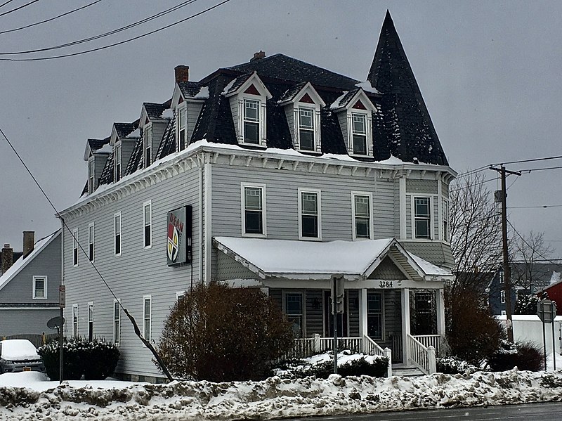
English: Dean Architects, 3284 Walden Avenue at Tyler Street, Depew, New York, February 2021. Erected in 1896 as one of the first batch of institutional buildings built by the Depew Improvement Company for the then-newly founded village, this serves as an anachronistic example of the Second Empire architectural style with its bracketed cornice, pedimented dormer windows framed by stylized columns, and of course, proud mansard roof. However, the shingle-sided, tent-roofed corner turret and the asymmetrical front porch with its off-center pediment both borrow from the Queen Anne style, which was much less passé at the time. The building functioned initially as the so-called Railroad Branch YMCA, which appears to have been defunct by 1912: a Depew Herald article from that year mentions a proposal to move the "former Y.M.C.A. building" to nearby Transit Road and convert it to a hotel, which apparently never materialized as the building remains on its original site. By 1939 it was in use as apartments, initially with a modest but respectable lower-middle-class tenant base composed mainly of workers at the machine shops and factories gathered around the New York Central Railroad line; the village's raison d'être. By the 1980s it had degenerated into a sleazy and dilapidated rooming house, and it was slated for demolition by 1998, when DeanSutton Architecture purchased the building and fully restored it for use as their offices. Dean Architects, the successor firm, remains headquartered there today. |
| Date | Prise le 19 février 2021, 10:43:48 |
| Source | Travail personnel |
| Auteur | Andre Carrotflower |
| Lieu de la prise de vue | | Voir cet endroit et d’autres images sur : OpenStreetMap |
|---|
Conditions d’utilisation
Moi, en tant que détenteur des droits d’auteur sur cette œuvre, je la publie sous la licence suivante :
Ce fichier est sous la licence Creative Commons Attribution – Partage dans les Mêmes Conditions 4.0 International.
- Vous êtes libre :
- de partager – de copier, distribuer et transmettre cette œuvre
- d’adapter – de modifier cette œuvre
- Sous les conditions suivantes :
- paternité – Vous devez donner les informations appropriées concernant l'auteur, fournir un lien vers la licence et indiquer si des modifications ont été faites. Vous pouvez faire cela par tout moyen raisonnable, mais en aucune façon suggérant que l’auteur vous soutient ou approuve l’utilisation que vous en faites.
- partage à l’identique – Si vous modifiez, transformez, ou vous basez sur cette œuvre, vous devez distribuer votre contribution sous la même licence ou une licence compatible avec celle de l’original.
Historique du fichier
Cliquer sur une date et heure pour voir le fichier tel qu'il était à ce moment-là.
| Date et heure | Vignette | Dimensions | Utilisateur | Commentaire | |
|---|---|---|---|---|---|
| actuel | 25 avril 2021 à 05:34 | | 1 791 × 1 342 (833 kio) | Andre Carrotflower | Uploaded own work with UploadWizard |
Utilisation du fichier
La page suivante utilise ce fichier :
Usage global du fichier
Les autres wikis suivants utilisent ce fichier :
- Utilisation sur ar.wikipedia.org
- Utilisation sur ca.wikipedia.org
- Utilisation sur ceb.wikipedia.org
- Utilisation sur cy.wikipedia.org
- Utilisation sur es.wikipedia.org
- Utilisation sur eu.wikipedia.org
- Utilisation sur ht.wikipedia.org
- Utilisation sur hu.wikipedia.org
- Utilisation sur it.wikipedia.org
- Utilisation sur lld.wikipedia.org
- Utilisation sur pl.wikipedia.org
- Utilisation sur sr.wikipedia.org
- Utilisation sur uk.wikipedia.org
- Utilisation sur www.wikidata.org