Fichier:Eastern Equatoria map.svg

Taille de cet aperçu PNG pour ce fichier SVG : 800 × 493 pixels. Autres résolutions : 320 × 197 pixels | 640 × 394 pixels | 1 024 × 631 pixels | 1 280 × 788 pixels | 2 560 × 1 576 pixels | 812 × 500 pixels.
Fichier d’origine (Fichier SVG, nominalement de 812 × 500 pixels, taille : 63 kio)
Ce fichier et sa description proviennent de Wikimedia Commons.
Description
| Description |
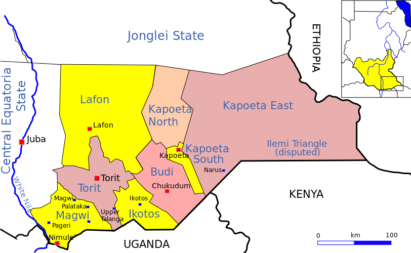
English: Sketch map of Eastern Equatoria state, South Sudan |
| Date | |
| Source | Travail personnel |
| Auteur | Aymatth2 |
Conditions d’utilisation
Moi, en tant que détenteur des droits d’auteur sur cette œuvre, je la publie sous la licence suivante :
| Ce fichier est disponible selon les termes de la licence Creative Commons CC0 Don universel au domaine public. | |
| La personne qui a associé une œuvre avec cet acte l’a placée dans le domaine public en renonçant mondialement à tous ses droits sur cette œuvre en vertu des lois relatives au droit d’auteur, ainsi qu’à tous les droits juridiques connexes et voisins qu’elle possédait sur l’œuvre, sans autre limite que celles imposées par la loi. Vous pouvez copier, modifier, distribuer et utiliser cette œuvre, y compris à des fins commerciales, sans qu’il soit nécessaire d’en demander la permission.
|
Historique du fichier
Cliquer sur une date et heure pour voir le fichier tel qu'il était à ce moment-là.
| Date et heure | Vignette | Dimensions | Utilisateur | Commentaire | |
|---|---|---|---|---|---|
| actuel | 16 juillet 2011 à 18:39 | | 812 × 500 (63 kio) | Aymatth2 | Corrections to county borders |
| 16 juillet 2011 à 18:38 |  | 812 × 500 (63 kio) | Aymatth2 | Corrections to county borders | |
| 13 juillet 2011 à 03:42 |  | 812 × 500 (54 kio) | Aymatth2 | Better context map | |
| 7 juillet 2011 à 18:02 |  | 812 × 500 (45 kio) | Aymatth2 | {{Information |Description ={{en|1=Sketch map of Central Equatoria, South Sudan}} |Source ={{own}} |Author =Aymatth2 |Date =2011-07-07 |Permission = |other_versions = }} Category:Sudan |
Utilisation du fichier
La page suivante utilise ce fichier :
Usage global du fichier
Les autres wikis suivants utilisent ce fichier :
- Utilisation sur ca.wikipedia.org
- Utilisation sur de.wikipedia.org
- Utilisation sur en.wikipedia.org
- Utilisation sur he.wikipedia.org
- Utilisation sur ja.wikipedia.org
- Utilisation sur no.wikipedia.org
- Utilisation sur pt.wikipedia.org
- Utilisation sur sv.wikipedia.org
- Utilisation sur vi.wikipedia.org
- Utilisation sur zu.wikipedia.org