Fichier:Eastern Frontier, Cape of Good Hope, ca 1835.png

Taille de cet aperçu : 684 × 600 pixels. Autres résolutions : 274 × 240 pixels | 548 × 480 pixels | 836 × 733 pixels.
Fichier d’origine (836 × 733 pixels, taille du fichier : 279 kio, type MIME : image/png)
Ce fichier et sa description proviennent de Wikimedia Commons.
Description
| Description |
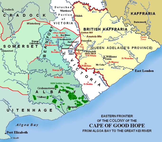
(i.e. period between 5th and 8th Xhosa Wars) 1820 British settler farms in the Albany district, or eastern Zuurveld
Settled colonial area (est. 1795), showing Grahamstown (est. 1812), and districts (est. 1820) in shades of pale green
Neutral zone (est. 1820), as agreed between Lord Charles Somerset and the Gaika (Ngqika) faction of the amaXhosa.
British Kaffraria (est. 1835), incl. East London (est. 1847): Gaika faction of amaXhosa and amaTembu under British protection.
Kaffraria, incl. Butterworth Wesleyan mission (est. 1827): amaTembu living inland and amaXhosa nearer the coast.
Mountains and necks, incl. Gaika's Hill 32°32′46″S 26°57′07″E / 32.54611°S 26.95194°E in the easternmost Winterberg.
Military forts, district boundaries and eastern frontier.
Notes
|
| Date | Redrawn and coloured in December 2007 |
| Source | Based on the source map below, last published in 1903. |
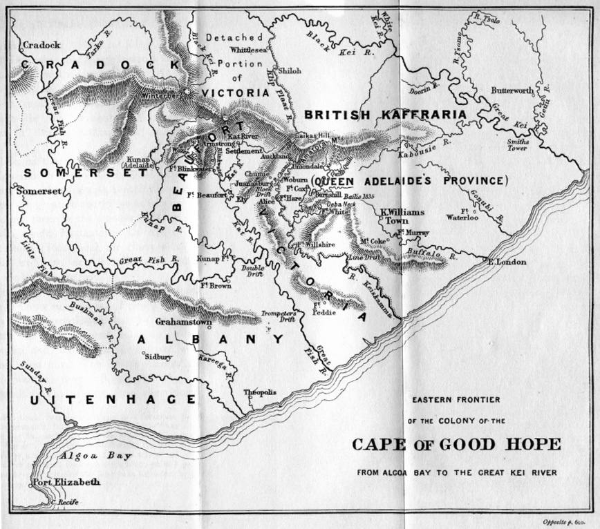
| Auteur | I created the map, based partly on the source map: Eastern frontier of the Colony of the Cape of Good Hope from Algoa Bay to the Great Kei river, which appears opposite page 620 of ‘The autobiography of Lieutenant-general Sir Harry Smith’ by G.C.B. Bart, Chapter xlviii, published 1903, as part of the online Build a Book initiative. JMK 11:03, 26 December 2007 (UTC) |
| Autres versions |
The original map relates to 1850 more or less, and may be John Arrowsmith's 1851 Eastern Frontier of the Colony of the Cape of Good Hope (and part of Kafirland), From Algoa Bay to the Great Kei River. Arrowsmith's lithograph was redrawn and compiled chiefly from M.S. Surveys & Sketches, communicated by Lt. Col. Mitchell late Survr. Genl. of the Colony and Captn. Wm Owen ...: _(14761876926).jpg) Compare also Arrowsmith, 1836:  |

Conditions d’utilisation
Moi, en tant que détenteur des droits d’auteur sur cette œuvre, je la publie sous les licences suivantes :

|
Vous avez la permission de copier, distribuer et modifier ce document selon les termes de la GNU Free Documentation License version 1.2 ou toute version ultérieure publiée par la Free Software Foundation, sans sections inaltérables, sans texte de première page de couverture et sans texte de dernière page de couverture. Un exemplaire de la licence est inclus dans la section intitulée GNU Free Documentation License. |
This file is licensed under the Creative Commons Attribution-Share Alike 4.0 International, 3.0 Unported, 2.5 Generic, 2.0 Generic and 1.0 Generic license.
- Vous êtes libre :
- de partager – de copier, distribuer et transmettre cette œuvre
- d’adapter – de modifier cette œuvre
- Sous les conditions suivantes :
- paternité – Vous devez donner les informations appropriées concernant l'auteur, fournir un lien vers la licence et indiquer si des modifications ont été faites. Vous pouvez faire cela par tout moyen raisonnable, mais en aucune façon suggérant que l’auteur vous soutient ou approuve l’utilisation que vous en faites.
- partage à l’identique – Si vous modifiez, transformez, ou vous basez sur cette œuvre, vous devez distribuer votre contribution sous la même licence ou une licence compatible avec celle de l’original.
Vous pouvez choisir l’une de ces licences.
Historique du fichier
Cliquer sur une date et heure pour voir le fichier tel qu'il était à ce moment-là.
| Date et heure | Vignette | Dimensions | Utilisateur | Commentaire | |
|---|---|---|---|---|---|
| actuel | 13 janvier 2021 à 02:57 | | 836 × 733 (279 kio) | JMK | add label |
| 13 mai 2019 à 13:41 |  | 836 × 733 (278 kio) | JMK | Change map colour east of Great Kei River (based on comments received), as it was never part of British Caffraria. Other minor changes. | |
| 30 décembre 2007 à 13:47 |  | 836 × 733 (253 kio) | JMK | Update | |
| 26 décembre 2007 à 12:58 |  | 836 × 733 (257 kio) | JMK | {{Information |Description=Eastern frontier of the Colony of the Cape of Good Hope from Algoa Bay to the Great Kei river *Settled colonial area shown in green, with districts established in 1820 shown in different shades of green *Neutral zone agreed on b | |
| 26 décembre 2007 à 12:55 |  | 836 × 733 (257 kio) | JMK | {{Information |Description=Eastern frontier of the Colony of the Cape of Good Hope from Algoa Bay to the Great Kei river *Settled colonial area shown in green, with districts established in 1820 shown in different shades of green *Neutral zone agreed on b |
Utilisation du fichier
Les 6 pages suivantes utilisent ce fichier :
Usage global du fichier
Les autres wikis suivants utilisent ce fichier :
- Utilisation sur af.wikipedia.org
- Utilisation sur ca.wikipedia.org
- Utilisation sur de.wikipedia.org
- Utilisation sur en.wikipedia.org
- Utilisation sur eo.wikipedia.org
- Utilisation sur es.wikipedia.org
- Utilisation sur fa.wikipedia.org
- Utilisation sur he.wikipedia.org
- Utilisation sur it.wikipedia.org
- Utilisation sur ja.wikipedia.org
- Utilisation sur mk.wikipedia.org
- Utilisation sur nl.wikipedia.org
- Utilisation sur ru.wikipedia.org
- Utilisation sur sv.wikipedia.org
- Utilisation sur uk.wikipedia.org
- Utilisation sur www.wikidata.org
- Utilisation sur xh.wikipedia.org