Fichier:Empire of the Kökturks.png

Taille de cet aperçu : 800 × 499 pixels. Autres résolutions : 320 × 200 pixels | 640 × 399 pixels | 1 024 × 638 pixels | 1 280 × 798 pixels | 1 745 × 1 088 pixels.
Fichier d’origine (1 745 × 1 088 pixels, taille du fichier : 2,56 Mio, type MIME : image/png)
Ce fichier et sa description proviennent de Wikimedia Commons.
Description
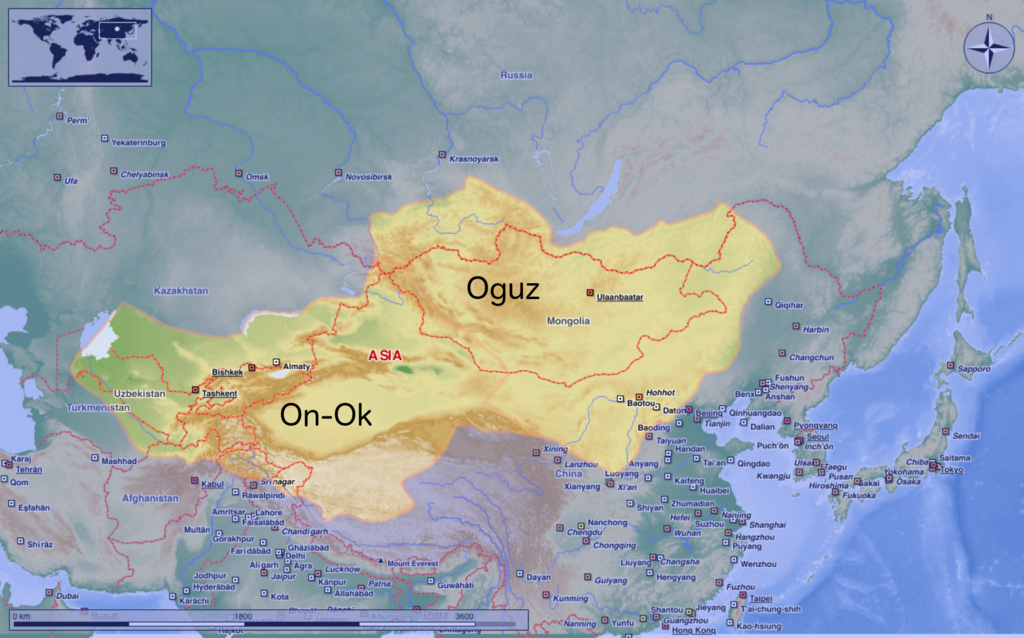
| Description | This map shows the kingdom of Kökturks after the division of the kingdom in 552. The grey area shows the area of On-Ok or the western Kökturks. The white area shows the area of the eastern Kökturk. This area was still in the sixth Century a Chinese protectorate. 745 the Kökturks were part of the Uyghur empire. After 840 Kökturks and the Uyghurs were conquered by the Kyrgyz. The source of this map: "Der große Atlas Weltgeschichte", Orbis Verlag 1990, ISBN 3-572-04755-2, P. 47 & 51 |
| Date | |
| Source | Travail personnel |
| Auteur | Hardcore-Mike |
Conditions d’utilisation
Moi, en tant que détenteur des droits d’auteur sur cette œuvre, je la publie sous la licence suivante :
Ce fichier est disponible selon les termes de la licence Creative Commons Attribution 3.0 Non transposée.
- Vous êtes libre :
- de partager – de copier, distribuer et transmettre cette œuvre
- d’adapter – de modifier cette œuvre
- Sous les conditions suivantes :
- paternité – Vous devez donner les informations appropriées concernant l'auteur, fournir un lien vers la licence et indiquer si des modifications ont été faites. Vous pouvez faire cela par tout moyen raisonnable, mais en aucune façon suggérant que l’auteur vous soutient ou approuve l’utilisation que vous en faites.
Historique du fichier
Cliquer sur une date et heure pour voir le fichier tel qu'il était à ce moment-là.
| Date et heure | Vignette | Dimensions | Utilisateur | Commentaire | |
|---|---|---|---|---|---|
| actuel | 10 août 2020 à 12:16 | | 1 745 × 1 088 (2,56 Mio) | MicBy67 | Leichte Überarbeitung der Grenzverläufe, Änderung des westl. Teilreiches in "On-Ok" |
| 26 juillet 2020 à 02:48 |  | 1 745 × 1 088 (2,56 Mio) | MicBy67 | Überarbeitung | |
| 1 novembre 2012 à 21:59 |  | 1 056 × 850 (1,17 Mio) | MicBy67 | Map fault repaired | |
| 1 novembre 2012 à 20:17 |  | 1 056 × 850 (1,17 Mio) | MicBy67 | {{Information |Description=This map shows the kingdom of Kökturks after the division of the kingdom in 552. The grey area shows the area of On-Ok or the western Kökturks. The white area shows the area of the eastern Kökturk. This area was still in t... |
Utilisation du fichier
La page suivante utilise ce fichier :
Usage global du fichier
Les autres wikis suivants utilisent ce fichier :
- Utilisation sur ast.wikipedia.org
- Utilisation sur cs.wikipedia.org
- Utilisation sur de.wikipedia.org
- Utilisation sur en.wikipedia.org
- Utilisation sur es.wikipedia.org
- Utilisation sur mn.wikipedia.org
- Utilisation sur pnb.wikipedia.org
- Utilisation sur sl.wikipedia.org
- Utilisation sur zh.wikipedia.org