Fichier:Europe 1748-1766.png
Taille de cet aperçu : 800 × 570 pixels. Autres résolutions : 320 × 228 pixels | 640 × 456 pixels | 1 024 × 730 pixels | 1 280 × 913 pixels | 2 560 × 1 825 pixels | 3 872 × 2 761 pixels.
Fichier d’origine (3 872 × 2 761 pixels, taille du fichier : 1,47 Mio, type MIME : image/png)
Ce fichier et sa description proviennent de Wikimedia Commons.
Description
| Description |
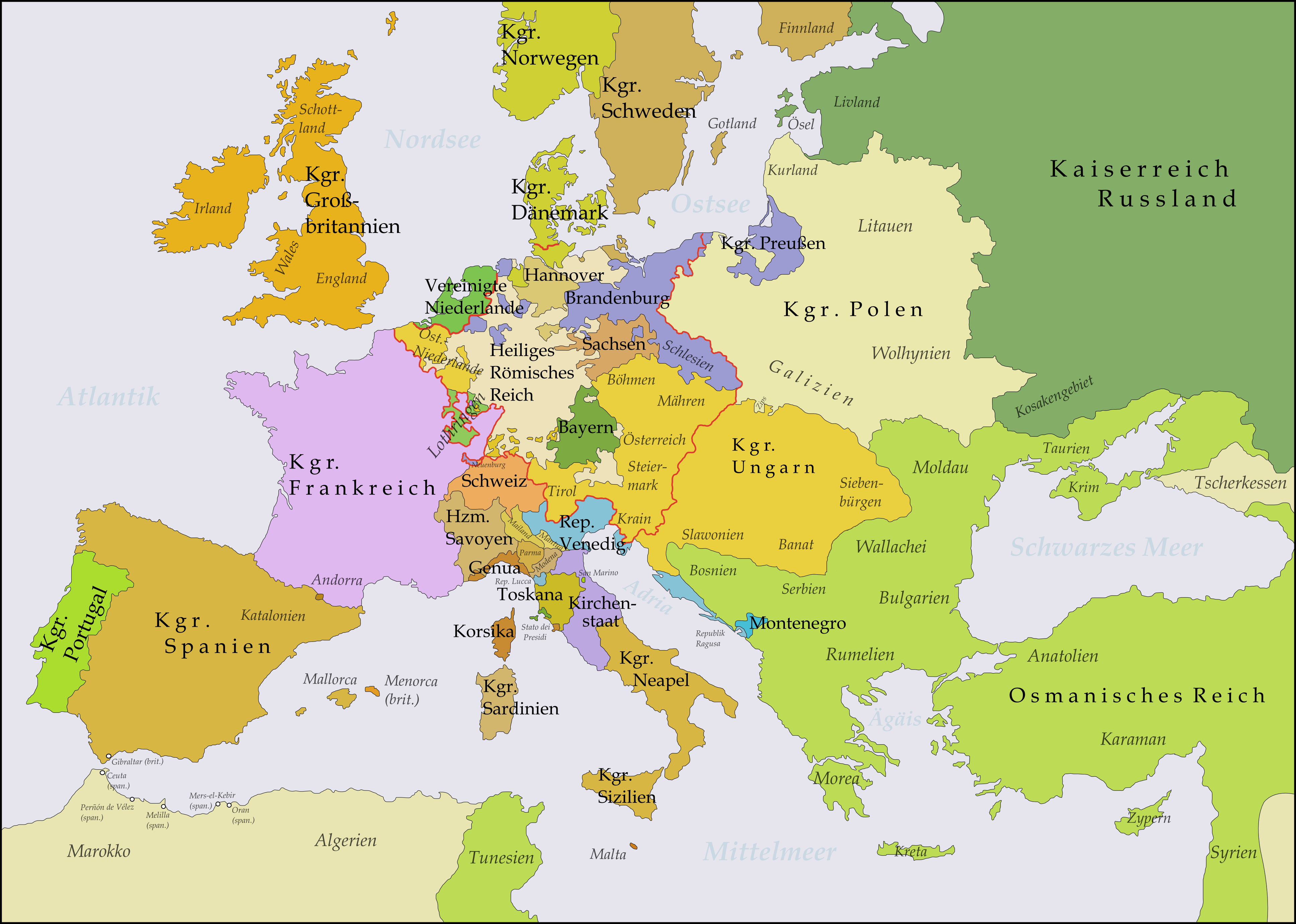
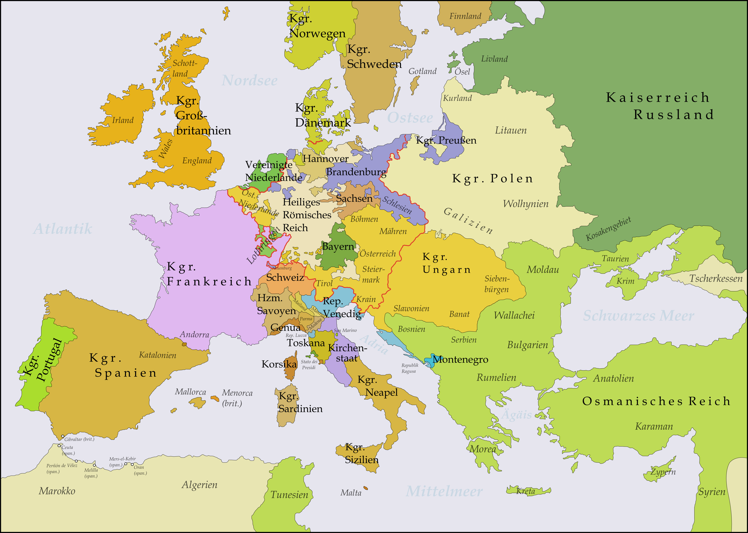
Deutsch: Diese Karte zeigt Europa in den Jahren nach dem Frieden von Aachen 1748 und in der Zeit des Siebenjährigen Krieges (1756-1763). Bis 1766 kam es zu keinen größeren geographischen Veränderungen in Europa.
Die Arbeit wurde mit Inkscape erstellt und beruht hauptsächlich auf einer Karte in: Putzger - Historischer Weltatlas, Berlin 1990, S.78f.
English: This map shows Europe in the years after the Treaty of Aix-la-Chapelle 1748 and the Seven Years' War (1756-1763). Europe did not see another major geographical change until 1766. The red line marks the borders of the Holy Roman Empire.
The work was created with Inkscape and is mainly based on a map in: Putzger - Historischer Weltatlas, Berlin 1990, 78 pp.
Français : Cette carte montre l'Europe dans les années après le Traité d'Aix-la-Chapelle (1748) et pendant les années de la Guerre des Sept Ans (1756-1763). L'Europe n'a pas vu un autre changement géographique important jusqu'à 1766.
Le travail a été créé avec Inkscape et il est basé principalement sur une carte dans: Putzger - Historischer Weltatlas, Berlin 1990, 78 pp.
Polski: Ta mapa ukazuje Europę w latach po pokoju w Akwizgranie z 1748 i wojnie siedmioletniej (1756-1763). Europa nie uświadczyła żadnych poważniejszych zmian geograficznych aż do 1766. Czerwona linia znaczy granice Świętego Cesarstwa Rzymskiego.
Praca została stworzona z użyciem Inkscape i powstała głównie na bazie mapy w: Putzger - Historischer Weltatlas, Berlin 1990, 78 pp.
Русский: Эта карта представляет Европу после заключения Аахенского мира в 1748 г. и во время Семилетней войны (1756-1763 гг.). До 1766 г. эта картина Европы не изменилась.
Эта работа нарисована с помощью программы Inkscape и основана на карте из книги: Putzger - Historischer Weltatlas, Berlin 1990, 78 cc. |
||
| Date | |||
| Source | Travail personnel | ||
| Auteur | Memnon335bc | ||
| Autres versions |
|

_en.png)
.png)
.jpg)
Conditions d’utilisation
Moi, en tant que détenteur des droits d’auteur sur cette œuvre, je la publie sous la licence suivante :
Ce fichier est disponible selon les termes de la licence Creative Commons Attribution 3.0 Non transposée.
- Vous êtes libre :
- de partager – de copier, distribuer et transmettre cette œuvre
- d’adapter – de modifier cette œuvre
- Sous les conditions suivantes :
- paternité – Vous devez donner les informations appropriées concernant l'auteur, fournir un lien vers la licence et indiquer si des modifications ont été faites. Vous pouvez faire cela par tout moyen raisonnable, mais en aucune façon suggérant que l’auteur vous soutient ou approuve l’utilisation que vous en faites.
Historique du fichier
Cliquer sur une date et heure pour voir le fichier tel qu'il était à ce moment-là.
| Date et heure | Vignette | Dimensions | Utilisateur | Commentaire | |
|---|---|---|---|---|---|
| actuel | 21 octobre 2017 à 04:51 | | 3 872 × 2 761 (1,47 Mio) | Bryanrutherford0 | Transferred control of Saaremaa and Hiiumaa to Russia (1721 Treaty of Nystad) and adjusted Russian-Swedish border in Finland to reflect Russian gains in the 1743 Treaty of Åbo after the Russo-Swedish War. |
| 5 novembre 2009 à 22:51 |  | 3 872 × 2 761 (1,47 Mio) | Alex:D | Border correction (Oltenia was part of Wallachia since 1738) | |
| 31 août 2009 à 23:03 |  | 3 872 × 2 761 (1,64 Mio) | Memnon335bc | Zips, PrussianBorders, Ostfriesland, Neuenburg, Reich-Borders corrected | |
| 31 août 2009 à 00:39 |  | 3 872 × 2 761 (1,64 Mio) | Memnon335bc | {{Information |Description={{en|1=This map shows Europe in the years after the Treaty of Aix-la-Chapelle 1748 and the Seven Years' War (1756-1763). Europe didn't see another major geographi |
Utilisation du fichier
La page suivante utilise ce fichier :
Usage global du fichier
Les autres wikis suivants utilisent ce fichier :
- Utilisation sur de.wikipedia.org
- 1748
- 1756
- Siebenjähriger Krieg
- Katharina II.
- Friede von Aachen (1748)
- Renversement des alliances
- Deutscher Dualismus
- Sächsische Armee
- Ostfriesland zur Zeit des Siebenjährigen Krieges
- Benutzer:KaterBegemot/Kartografen
- Benutzer Diskussion:Niabot/Archiv/2011
- Benutzer:Memnon335bc
- Deutsch-russische Beziehungen
- Benutzer:Mr N/Landkarten und Übersichten für Bücher
- Wikipedia:Bücher/Die Epoche der Aufklärung (2)/Quellen & Bildanhang
- Benutzer:Eandré/Karten
- Nordisches System
- Preußisch-russischer Allianzvertrag (1762)
- Preußisch-russischer Allianzvertrag (1764)
- Brandenburgisch-sächsische Beziehungen
- Utilisation sur de.wikibooks.org
- Utilisation sur es.wikipedia.org
- Utilisation sur hr.wikipedia.org
- Utilisation sur lb.wikipedia.org
- Utilisation sur nl.wikipedia.org
- Utilisation sur pfl.wikipedia.org
- Utilisation sur pl.wikipedia.org
- Utilisation sur ro.wikipedia.org
- Utilisation sur ru.wikipedia.org
- Utilisation sur sh.wikipedia.org
- Utilisation sur sl.wikipedia.org
- Utilisation sur uk.wikipedia.org
- Utilisation sur vi.wikipedia.org
- Utilisation sur zh.wikipedia.org