Fichier:Faults in Moenkopi Formation Moab Canyon Utah USA 01.jpg

Taille de cet aperçu : 800 × 532 pixels. Autres résolutions : 320 × 213 pixels | 640 × 426 pixels | 1 024 × 681 pixels | 1 280 × 851 pixels | 3 008 × 2 000 pixels.
Fichier d’origine (3 008 × 2 000 pixels, taille du fichier : 3,63 Mio, type MIME : image/jpeg)
Ce fichier et sa description proviennent de Wikimedia Commons.
Description
| Description |
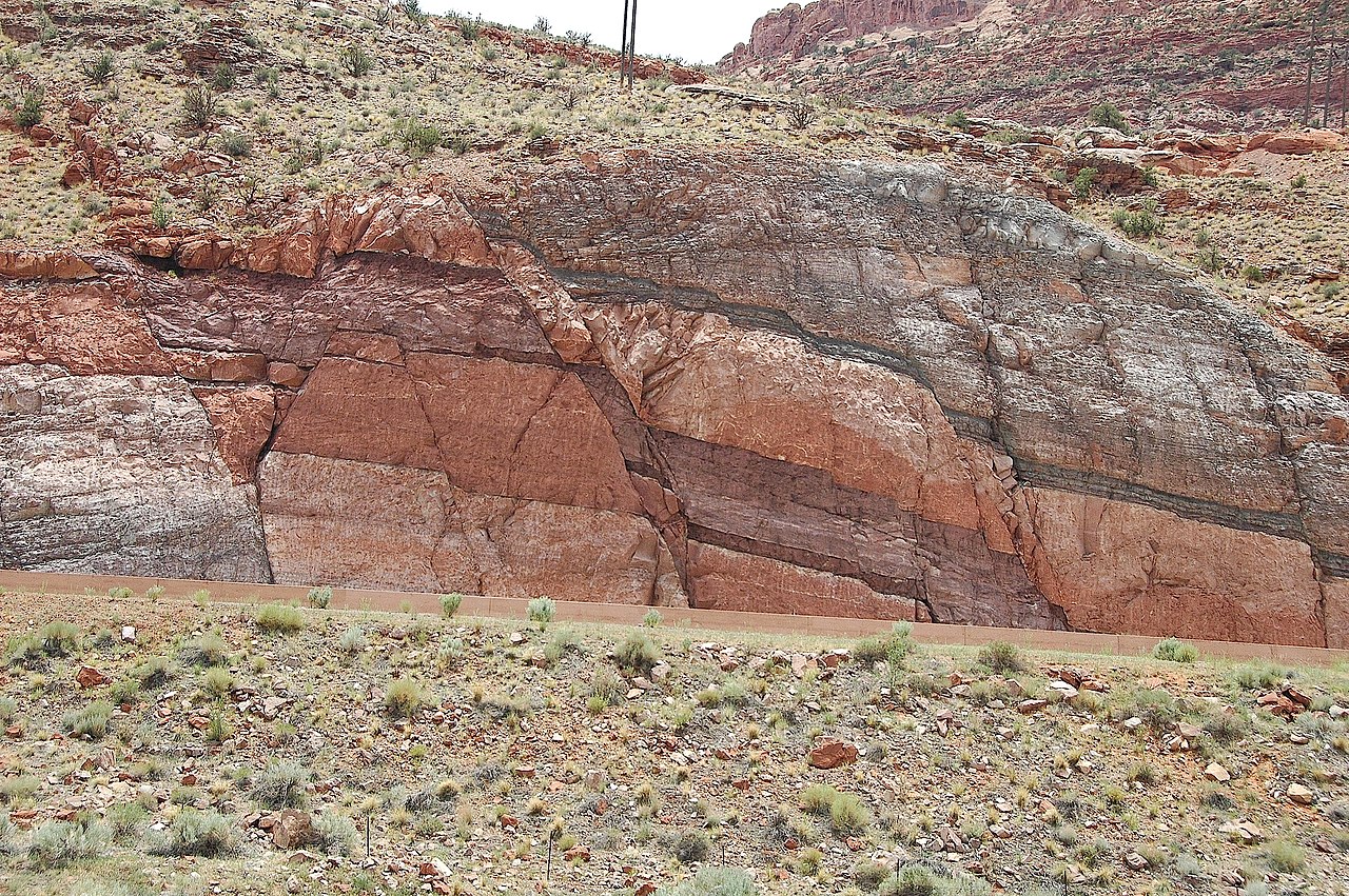
English: This image shows one of the only outcrops of the Pennsylvanian Period Honaker Trail Formation that may be viewed in the vicinity of Moab. In this setting the Honaker Trail Formation serves as the base of a strata graphic sequence which form the cliffs that occur on the west side of the Moab valley. This outcrop occurs across highway 191, immediately opposite and directly south of, the visitor center parking lot at Arches National Park. The Honaker Trail Formation underlies the visible strata throughout the area, but is buried and impossible to view elsewhere in the near vicinity of Moab. The fault and the road cut for highway 191 provide a rare circumstance where visitors to Moab, Arches National Park, and Canyonlands National Park may see this approximately 300 miilion year old Pennsylvanian Period layer of rock.
sources: 1) http://www.gly.uga.edu/railsback/VFT/VFTMoabFault.html 2) http://geology.byu.edu/home/sites/default/files/geo-stud-volume-19-part-2-melton1.pdf |
| Date | |
| Source | https://www.flickr.com/photos/jsjgeology/8471260787/in/set-72157632763455730 |
| Auteur | James St. John (jsj1771) https://www.flickr.com/people/jsjgeology/ |
| Position de l'objet | | Voir cet endroit et d’autres images sur : OpenStreetMap |
|---|
Conditions d’utilisation
| Cette image a été originellement postée sur Flickr par jsj1771 à l'adresse https://www.flickr.com/photos/47445767@N05/8471260787. Elle a été passée en revue le 14 décembre 2013 par le robot FlickreviewR, qui a confirmé qu'elle se trouvait sous licence cc-by-2.0. |
Ce fichier est disponible selon les termes de la licence Creative Commons Attribution 2.0 Générique.
- Vous êtes libre :
- de partager – de copier, distribuer et transmettre cette œuvre
- d’adapter – de modifier cette œuvre
- Sous les conditions suivantes :
- paternité – Vous devez donner les informations appropriées concernant l'auteur, fournir un lien vers la licence et indiquer si des modifications ont été faites. Vous pouvez faire cela par tout moyen raisonnable, mais en aucune façon suggérant que l’auteur vous soutient ou approuve l’utilisation que vous en faites.
Historique du fichier
Cliquer sur une date et heure pour voir le fichier tel qu'il était à ce moment-là.
| Date et heure | Vignette | Dimensions | Utilisateur | Commentaire | |
|---|---|---|---|---|---|
| actuel | 14 décembre 2013 à 19:58 | | 3 008 × 2 000 (3,63 Mio) | GeoWriter | User created page with UploadWizard |
Utilisation du fichier
Les 2 pages suivantes utilisent ce fichier :
Usage global du fichier
Les autres wikis suivants utilisent ce fichier :
- Utilisation sur en.wikipedia.org
- Utilisation sur he.wikipedia.org
- Utilisation sur ky.wikipedia.org
- Utilisation sur sk.wikipedia.org
- Utilisation sur www.wikidata.org