Fichier:Flight 1549-OptionsNotTaken.PNG

Taille de cet aperçu : 686 × 600 pixels. Autres résolutions : 275 × 240 pixels | 549 × 480 pixels | 1 000 × 874 pixels.
Fichier d’origine (1 000 × 874 pixels, taille du fichier : 727 kio, type MIME : image/png)
Historique du fichier
Cliquer sur une date et heure pour voir le fichier tel qu'il était à ce moment-là.
| Date et heure | Vignette | Dimensions | Utilisateur | Commentaire | |
|---|---|---|---|---|---|
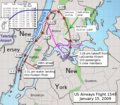
| actuel | 12 février 2019 à 12:59 |  | 1 000 × 874 (727 kio) | Chrysfrom Houston | Direction of the Canadian Geese Flock was in error (reversed). Now fixed. Other tweaks made also. |
| 14 septembre 2017 à 02:23 |  | 1 000 × 874 (775 kio) | Tuntable | Added location and time of the actual bird strike. | |
| 5 juin 2016 à 03:53 |  | 1 000 × 874 (731 kio) | ChrisnHouston | Re-adding Teterboro runway diagram, to scale. | |
| 27 décembre 2015 à 00:25 |  | 1 000 × 874 (836 kio) | MIDI | Reverted to version as of 19:42, 12 March 2010 (UTC) Map/sat overlay is not free-use | |
| 18 février 2012 à 05:29 |  | 1 000 × 874 (831 kio) | ChrisnHouston | Approximate location of, and trajectory to, Teterboro Airport added in BLUE. | |
| 12 mars 2010 à 20:42 |  | 1 000 × 874 (836 kio) | ChrisnHouston | {{Information |Description={{en|1=Optional flight paths not taken shown in purple. (Teterboro was reachable as well, but did not have this ditching alternative that an attempt back to LaGuardia had. (Derivative from map with actual flight path overlaid by |
Utilisation du fichier
La page suivante utilise ce fichier :
Usage global du fichier
Les autres wikis suivants utilisent ce fichier :
- Utilisation sur en.wikipedia.org
- Utilisation sur en.wikibooks.org
- Utilisation sur he.wikipedia.org
- Utilisation sur oc.wikipedia.org
- Utilisation sur simple.wikipedia.org

