Fichier:Front elevation - Kate Chopin House, State Highway 495, Cloutierville, Natchitoches Parish, LA HABS LA,35-CLOU,1-1.tif

Taille de cet aperçu JPG pour ce fichier TIF : 800 × 574 pixels. Autres résolutions : 320 × 230 pixels | 640 × 459 pixels | 1 024 × 735 pixels | 1 280 × 918 pixels | 2 560 × 1 837 pixels | 4 911 × 3 524 pixels.
Fichier d’origine (4 911 × 3 524 pixels, taille du fichier : 16,51 Mio, type MIME : image/tiff)
Ce fichier et sa description proviennent de Wikimedia Commons.
Description
| Front elevation - Kate Chopin House, State Highway 495, Cloutierville, Natchitoches Parish, LA | ||||
|---|---|---|---|---|
| Titre |
Front elevation - Kate Chopin House, State Highway 495, Cloutierville, Natchitoches Parish, LA |
|||
| Description |
Chopin, Kate; Price, Virginia Barrett, transmitter; Morgan, Nancy I, M, sponsor; Cane River National Heritage Area Commission, sponsor; Louisiana Tech University, School of Architecture, sponsor; Martin, F Lestar, faculty sponsor; Carwile, Guy, faculty sponsor; Foster, Brad; Quinn, Zach; Sherwood, Doug; Smith, Connie; Boucher, Jack E, photographer; Hayward, Jenes, delineator; Roberts, William, delineator |
|||
| Lieu représenté | Louisiana; Natchitoches Parish; Cloutierville | |||
| Date | Documentation compiled after 1933 | |||
| Dimensions | 5 x 7 in. | |||
| Lieu actuel |
Library of Congress Prints and Photographs Division Washington, D.C. 20540 USA http://hdl.loc.gov/loc.pnp/pp.print |
|||
| Numéro d’inventaire |
HABS LA,35-CLOU,1-1 |
|||
| Attribution de l’acquisition |
|
|||
| Notes |
|
|||
| Références |
|
|||
| Source | https://www.loc.gov/pictures/item/la0400.photos.204802p | |||
| Autorisation (Réutilisation de ce fichier) |
|
|||

| Position de l'objet | | Voir cet endroit et d’autres images sur : OpenStreetMap |
|---|
Historique du fichier
Cliquer sur une date et heure pour voir le fichier tel qu'il était à ce moment-là.
| Date et heure | Vignette | Dimensions | Utilisateur | Commentaire | |
|---|---|---|---|---|---|
| actuel | 18 juillet 2014 à 00:59 | 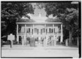 | 4 911 × 3 524 (16,51 Mio) | Fæ | GWToolset: Creating mediafile for Fæ. HABS 17 July 2014 (1401:1600) |
Utilisation du fichier
La page suivante utilise ce fichier :
Usage global du fichier
Les autres wikis suivants utilisent ce fichier :
- Utilisation sur cs.wikipedia.org