Fichier:Garibaldi Lake area map.jpg
Pas de plus haute résolution disponible.
Garibaldi_Lake_area_map.jpg (574 × 468 pixels, taille du fichier : 81 kio, type MIME : image/jpeg)
Ce fichier et sa description proviennent de Wikimedia Commons.
Description
| Description |
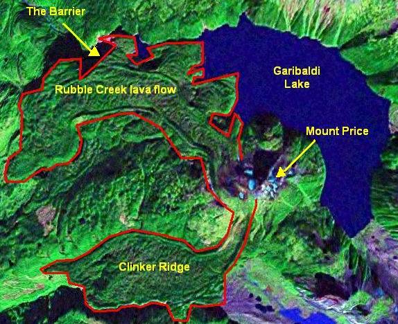
English: Map of volcanic features around Garibaldi Lake. |
| Date | |
| Source | NASA World Wind |
| Auteur | NASA/Black Tusk |
| Autorisation (Réutilisation de ce fichier) |
NASA, public domian |
Conditions d’utilisation
| Cette image est dans le domaine public car elle est constituée d'une capture d'écran du logiciel World Wind de la NASA qui utilise des données du domaine public, comme Blue Marble, MODIS, Landsat, SRTM, USGS ou GLOBE.
|
 |
Historique du fichier
Cliquer sur une date et heure pour voir le fichier tel qu'il était à ce moment-là.
| Date et heure | Vignette | Dimensions | Utilisateur | Commentaire | |
|---|---|---|---|---|---|
| actuel | 13 novembre 2012 à 17:38 | | 574 × 468 (81 kio) | Black Tusk | make image smaller |
| 28 septembre 2008 à 20:04 |  | 659 × 548 (112 kio) | Black Tusk | {{Information |Description={{en|1=Map of volcanic features around Garibaldi Lake.}} |Source=NASA World Wind |Author=NASA/Black Tusk |Date=September 28, 2008 |Permission=NASA, public domian |other_versions= }} <!--{{ImageUpload|ful |
Utilisation du fichier
Les 2 pages suivantes utilisent ce fichier :
Usage global du fichier
Les autres wikis suivants utilisent ce fichier :
- Utilisation sur ar.wikipedia.org
- Utilisation sur en.wikipedia.org
- Utilisation sur ja.wikipedia.org