Fichier:GreaterAmericaMap.jpg

Taille de cet aperçu : 800 × 558 pixels. Autres résolutions : 320 × 223 pixels | 640 × 446 pixels | 1 024 × 714 pixels | 1 280 × 893 pixels | 1 537 × 1 072 pixels.
Fichier d’origine (1 537 × 1 072 pixels, taille du fichier : 325 kio, type MIME : image/jpeg)
Ce fichier et sa description proviennent de Wikimedia Commons.

|
Cette image (de type locator map) devrait être recréée dans un format vectoriel, en tant que fichier SVG. Cela offrirait plusieurs avantages : voir Commons:Media for cleanup pour plus d'informations. Si une version SVG de cette image est déjà disponible, merci de bien vouloir l'envoyer. Après cela, remplacez ce modèle par {{vector version available|nouveau nom d'image.svg}}.
|


Description
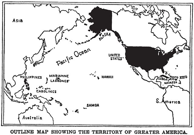
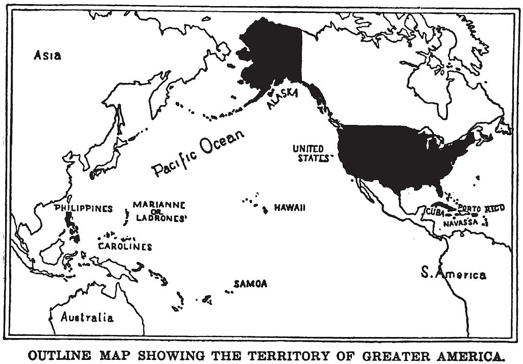
English: Map of "Greater America", 1899.
Shows territories and possessions of the United States after the Spanish American War, including Alaska, Cuba, Hawaii, Marianas, Philippines, Puerto Rico, and Samoa in addition to the continental United States.
Printed in book "War in the Philippines" by Marshall Everet.
Scanned from original 1899 printing by Infrogmation, previously uploaded by him to en:Wikipedia 23:36, 22 October 2003
en:Image:GreaterAmericaMap.jpg
Conditions d’utilisation
Ce document est dans le domaine public aux États-Unis. Ceci s'applique aux travaux des États-Unis où le copyright a expiré, souvent parce que sa première publication s'est produite avant le 1er janvier 1929. Voir cette page pour davantage d'explication.
|
 | |
 |
Cette image peut ne pas être dans le domaine public en dehors des États-Unis (ceci s'applique particulièrement au Canada, en Chine (pas Hong Kong, Macao, ni Taïwan), en Allemagne ou en Suisse). Le créateur et l'année de la publication sont l'information essentielle et doivent être fournis.
|
Historique du fichier
Cliquer sur une date et heure pour voir le fichier tel qu'il était à ce moment-là.
| Date et heure | Vignette | Dimensions | Utilisateur | Commentaire | |
|---|---|---|---|---|---|
| actuel | 25 août 2010 à 00:17 | | 1 537 × 1 072 (325 kio) | Quazgaa | Higher Res |
| 23 mai 2005 à 14:55 |  | 571 × 391 (70 kio) | Shizhao | Map of "Greater America", scanned from 1899 book. Shows territories and possessions of the United States after the Spanish American War, including Alaska, Cuba, Hawaii, Marianas, Philippines, Puerto Rico, and Samoa |
Utilisation du fichier
Les 4 pages suivantes utilisent ce fichier :
Usage global du fichier
Les autres wikis suivants utilisent ce fichier :
- Utilisation sur ba.wikipedia.org
- Utilisation sur be.wikipedia.org
- Utilisation sur da.wikipedia.org
- Utilisation sur en.wikipedia.org
- Utilisation sur en.wikibooks.org
- Utilisation sur en.wikiquote.org
- Utilisation sur es.wikipedia.org
- Utilisation sur fa.wikipedia.org
- Utilisation sur hu.wikipedia.org
- Utilisation sur hy.wikipedia.org
- Utilisation sur id.wikipedia.org
- Utilisation sur it.wikipedia.org
- Utilisation sur ja.wikipedia.org
- Utilisation sur ko.wikipedia.org
- Utilisation sur nl.wikipedia.org
- Utilisation sur no.wikipedia.org
- Utilisation sur pl.wikipedia.org
- Utilisation sur pt.wikipedia.org
- Utilisation sur ru.wikipedia.org
- Utilisation sur tt.wikipedia.org
- Utilisation sur uk.wikipedia.org
- Utilisation sur vi.wikipedia.org
- Utilisation sur zh.wikipedia.org