Fichier:Hudson Bay Route Plan of the Nelson Estuary (1927).jpg

Taille de cet aperçu : 800 × 403 pixels. Autres résolutions : 320 × 161 pixels | 640 × 322 pixels | 1 024 × 516 pixels | 1 280 × 644 pixels | 2 560 × 1 289 pixels | 7 516 × 3 784 pixels.
Fichier d’origine (7 516 × 3 784 pixels, taille du fichier : 10,55 Mio, type MIME : image/jpeg)
Ce fichier et sa description proviennent de Wikimedia Commons.
Description
| Description |
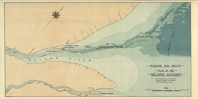
Palmer, F. Hudson Bay Route Plan of the Nelson Estuary [map]. 1:35,640. In: F. Palmer. Report on the Section of a Terminal Port for the Hudson Bay Railway. London: Harrison & Sons, Ltd., 1927. Depths of water are indicated by contours reduced to a datum of low water spring tides Report submitted to Charles A . Dunning, Minister for Railways and Canals, Government of Canada Image Courtesy of University of Manitoba : Archives & Special Collections |
| Date | |
| Source | Hudson Bay Route Plan of the Nelson Estuary (1927) |
| Auteur | Creator:F. Palmer via Wyman Laliberte from Edmonton, Canada |
Conditions d’utilisation
Ce fichier est disponible selon les termes de la licence Creative Commons Attribution 2.0 Générique.
- Vous êtes libre :
- de partager – de copier, distribuer et transmettre cette œuvre
- d’adapter – de modifier cette œuvre
- Sous les conditions suivantes :
- paternité – Vous devez donner les informations appropriées concernant l'auteur, fournir un lien vers la licence et indiquer si des modifications ont été faites. Vous pouvez faire cela par tout moyen raisonnable, mais en aucune façon suggérant que l’auteur vous soutient ou approuve l’utilisation que vous en faites.
| Cette image a été originellement postée sur Flickr par Manitoba Historical Maps à l'adresse https://www.flickr.com/photos/11496488@N07/3749611013. Elle a été passée en revue le 20 avril 2013 par le robot FlickreviewR, qui a confirmé qu'elle se trouvait sous licence cc-by-2.0. |
| Annotations | Cette image est annotée : Voir les annotations sur Wikimedia Commons |
.jpg)

.jpg?uselang=fr)
.jpg)
Historique du fichier
Cliquer sur une date et heure pour voir le fichier tel qu'il était à ce moment-là.
| Date et heure | Vignette | Dimensions | Utilisateur | Commentaire | |
|---|---|---|---|---|---|
| actuel | 20 avril 2013 à 05:50 | | 7 516 × 3 784 (10,55 Mio) | Geo Swan | {{Information |Description=Palmer, F. Hudson Bay Route Plan of the Nelson Estuary [map]. 1:35,640. In: F. Palmer. Report on the Section of a Terminal Port for the Hudson Bay Railway. London: Harrison & Sons, Ltd., 1927. Depths of water are indicated ... |
Utilisation du fichier
La page suivante utilise ce fichier :
Usage global du fichier
Les autres wikis suivants utilisent ce fichier :
- Utilisation sur en.wikipedia.org
- Utilisation sur nn.wikipedia.org
- Utilisation sur no.wikipedia.org
- Utilisation sur sr.wikipedia.org
.jpg)