Fichier:Hungarian Regional Autonomy02 map.png
Taille de cet aperçu : 552 × 600 pixels. Autres résolutions : 221 × 240 pixels | 442 × 480 pixels | 760 × 826 pixels.
Fichier d’origine (760 × 826 pixels, taille du fichier : 122 kio, type MIME : image/png)
Ce fichier et sa description proviennent de Wikimedia Commons.
Description
| Description |
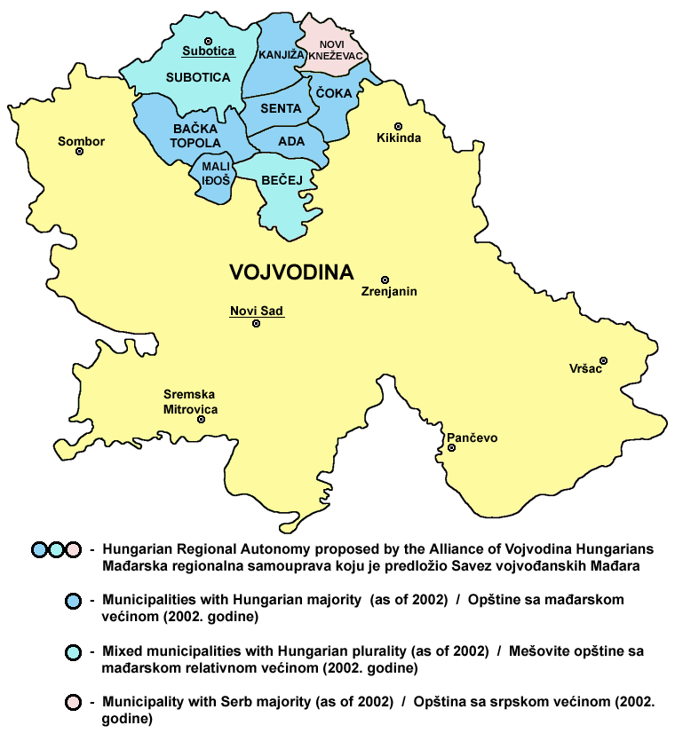
English: Map of the proposed Hungarian Regional Autonomy in northern Vojvodina (proposal of the Alliance of Vojvodina Hungarians political party).
Српски / srpski: Мапа предложене Мађарске регионалне самоуправе на северу Војводине (предлог политичке партије Савез војвођанских Мађара). |
| Date | 10 février 2009 (date de téléversement originale) |
| Source | La source n’a pas pu être reconnue automatiquement. « Travail personnel » supposé (étant donné la revendication de droit d’auteur). |
| Auteur | L’auteur n’a pas pu être identifié automatiquement. Il est supposé qu'il s'agit de : PANONIAN (étant donné la revendication de droit d’auteur). |
References
Created according to these sources:
- 1. Info about borders of the proposed Hungarian Regional Autonomy was found here:
- The Alliance of Vojvodina Hungarians web site - [1][lien mort] (Dokument o autonomiji - Mađarska regionalna samouprava)
- [2] (Uloga mađarske zajednice u Srbiji, Helsinški odbor za ljudska prava u Srbiji, Beograd, 2009, page 20)
- [3] (Prevladavanje prošlosti i potencijal za nadvladavanje inter-etničkih sukoba u Vojvodini, Centar za razvoj civilnog društva, 2002, page 78)
- [4] (Vojvodina expects imminent endorsement of its new Statute of Autonomy, www.nationalia.info, 18/12/2008)
- [5] (Istraživanje novosadske Agencije Skan pokazalo - Vojvođani hoće veću autonomiju, Glas javnosti, 07. Mart 2001.)
- 2. Info about ethnic composition of municipalities: Popis stanovništva, domaćinstava i stanova u 2002, Stanovništvo, knjiga 1, Nacionalna ili etnička pripadnost - podaci po naseljima, Republika Srbija - Republički zavod za statistiku, Beograd, februar 2003.
- 3. Provincial and municipal borders and locations of sizable cities: Slobodan Radovanović, Geografski atlas, Magic Map, Smederevska Palanka, 2001.
Source and licence
self made map by user:PANONIAN
Conditions d’utilisation
| Moi, propriétaire des droits d’auteur sur cette œuvre, la place dans le domaine public. Ceci s'applique dans le monde entier. Dans certains pays, ceci peut ne pas être possible ; dans ce cas : J’accorde à toute personne le droit d’utiliser cette œuvre dans n’importe quel but, sans aucune condition, sauf celles requises par la loi. |
Historique du fichier
Cliquer sur une date et heure pour voir le fichier tel qu'il était à ce moment-là.
| Date et heure | Vignette | Dimensions | Utilisateur | Commentaire | |
|---|---|---|---|---|---|
| actuel | 25 octobre 2011 à 21:30 | | 760 × 826 (122 kio) | PANONIAN | improved version |
| 19 juillet 2009 à 15:50 |  | 957 × 638 (44 kio) | PANONIAN | ||
| 10 février 2009 à 02:03 |  | 972 × 579 (22 kio) | PANONIAN | map of the proposed Hungarian regional autonomy in Vojvodina (self made) {{PD-self}} Category:Maps of the politics of Vojvodina |
Utilisation du fichier
La page suivante utilise ce fichier :
Usage global du fichier
Les autres wikis suivants utilisent ce fichier :
- Utilisation sur be-tarask.wikipedia.org
- Utilisation sur br.wikipedia.org
- Utilisation sur en.wikipedia.org
- Utilisation sur hr.wikipedia.org
- Utilisation sur hu.wikipedia.org
- Utilisation sur it.wikipedia.org
- Utilisation sur ro.wikipedia.org
- Utilisation sur ru.wikipedia.org
- Utilisation sur sh.wikipedia.org
- Utilisation sur sr.wikipedia.org
- Utilisation sur tr.wikipedia.org
- Utilisation sur uk.wikipedia.org