Fichier:ImprovedTownlandsWithLegendInThurlesCivilParish.jpg

Taille de cet aperçu : 800 × 565 pixels. Autres résolutions : 320 × 226 pixels | 640 × 452 pixels | 1 024 × 723 pixels | 1 280 × 904 pixels | 2 040 × 1 441 pixels.
Fichier d’origine (2 040 × 1 441 pixels, taille du fichier : 1 011 kio, type MIME : image/jpeg)
Ce fichier et sa description proviennent de Wikimedia Commons.
Description
| Description |
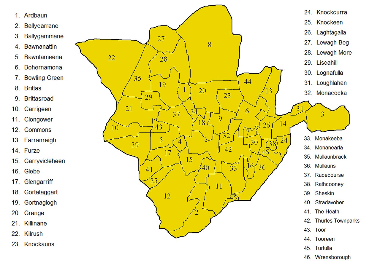
English: Improved map showing townlands in Thurles civil parish in North Tipperary, the improvement being to deal correctly with the boundary of that part of Farranreigh that protrudes into Bohernamona. A version of this map without the names is available here. Both maps are derived from derived from information in this Ordnance Survey map, corrected with information taken from this newer Ordnance Survey map in order to decide how to handle the boundary of that part of Farranreigh that protrudes into Bohernamona. |
| Date | |
| Source | Travail personnel |
| Auteur | MartinCollin |
Conditions d’utilisation
Moi, en tant que détenteur des droits d’auteur sur cette œuvre, je la publie sous la licence suivante :
Ce fichier est disponible selon les termes de la licence Creative Commons Attribution – Partage dans les Mêmes Conditions 3.0 (non transposée).
- Vous êtes libre :
- de partager – de copier, distribuer et transmettre cette œuvre
- d’adapter – de modifier cette œuvre
- Sous les conditions suivantes :
- paternité – Vous devez donner les informations appropriées concernant l'auteur, fournir un lien vers la licence et indiquer si des modifications ont été faites. Vous pouvez faire cela par tout moyen raisonnable, mais en aucune façon suggérant que l’auteur vous soutient ou approuve l’utilisation que vous en faites.
- partage à l’identique – Si vous modifiez, transformez, ou vous basez sur cette œuvre, vous devez distribuer votre contribution sous la même licence ou une licence compatible avec celle de l’original.
Historique du fichier
Cliquer sur une date et heure pour voir le fichier tel qu'il était à ce moment-là.
| Date et heure | Vignette | Dimensions | Utilisateur | Commentaire | |
|---|---|---|---|---|---|
| actuel | 25 septembre 2012 à 23:22 | | 2 040 × 1 441 (1 011 kio) | MartinCollin | User created page with UploadWizard |
Utilisation du fichier
Usage global du fichier
Les autres wikis suivants utilisent ce fichier :
- Utilisation sur cs.wikipedia.org
- Utilisation sur en.wikipedia.org
- Utilisation sur eu.wikipedia.org
- Utilisation sur gl.wikipedia.org
- Utilisation sur it.wikipedia.org
- Utilisation sur sk.wikipedia.org
- Utilisation sur ur.wikipedia.org