Fichier:IrishSeaReliefMap.jpg
Taille de cet aperçu : 415 × 600 pixels. Autres résolutions : 166 × 240 pixels | 332 × 480 pixels | 531 × 768 pixels | 1 043 × 1 507 pixels.
Fichier d’origine (1 043 × 1 507 pixels, taille du fichier : 2,15 Mio, type MIME : image/jpeg)
Ce fichier et sa description proviennent de Wikimedia Commons.
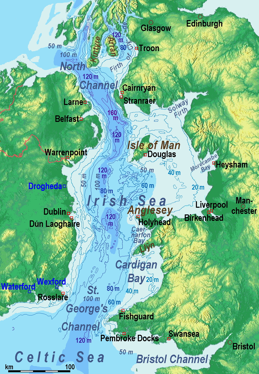
Description
| Description |
A map of the en:Irish Sea. Major ports shown with red marks. freight-only ports in blue. |
| Date | old map 2005-08-03; new map 2014-05-11 |
| Source | old map: http://www.vindaloo.uklinux.net/jjg/code/tmutils.html-> new map: Maps for Free and Travail personnel |
| Auteur | old one Users SFC9394, Seabhcan on en.wikipedia, new one Ulamm (talk) 01:37, 11 May 2014 (UTC) |
| Autorisation (Réutilisation de ce fichier) |
old map: from http://www.vindaloo.uklinux.net/jjg/code/tmutils.html. Released to public domain by creator. |
| Autres versions |
History of the od map
Old map riginally from en.wikipedia; description page is (was) here
- 14:22, 20 March 2006 SFC9394 461×561 (85,860 bytes) (Corrected locations for Cairnryan & Stranraer)
- 10:56, 25 November 2005 Seabhcan 461×561 (73,292 bytes) (Removed the ports of Heysham and Fleetwood, to which en:User:Robdurbar took offence. )
- 16:23, 3 August 2005 Seabhcan 461×561 (95,162 bytes) (Added channel names)
- 15:50, 3 August 2005 Seabhcan 461×561 (93,219 bytes) (A map of the en:Irish Sea Major ports shown in red. freight only ports in blue. from [1]. Released to public domain by creator.)
Sources of information for the new map
- internal report Nr. 174 of the National Oceanography Centre (Liverpool)
- http://www.dcenr.gov.ie (Department of Communications, Energy and Natural Resources) -> IOSEA4Annex–Master–r02–Fiinal.pdf (Fourth Strategic Environmental Assessment for Oil and Gas ACtivity in Irelands Offshore Waters) -> figures 2.1 & 2.2a
Conditions d’utilisation
Moi, en tant que détenteur des droits d’auteur sur cette œuvre, je la publie sous la licence suivante :
Ce fichier est disponible selon les termes de la licence Creative Commons Attribution – Partage dans les Mêmes Conditions 3.0 (non transposée).
- Vous êtes libre :
- de partager – de copier, distribuer et transmettre cette œuvre
- d’adapter – de modifier cette œuvre
- Sous les conditions suivantes :
- paternité – Vous devez donner les informations appropriées concernant l'auteur, fournir un lien vers la licence et indiquer si des modifications ont été faites. Vous pouvez faire cela par tout moyen raisonnable, mais en aucune façon suggérant que l’auteur vous soutient ou approuve l’utilisation que vous en faites.
- partage à l’identique – Si vous modifiez, transformez, ou vous basez sur cette œuvre, vous devez distribuer votre contribution sous la même licence ou une licence compatible avec celle de l’original.
(Uploaded using CommonsHelper or PushForCommons)
Historique du fichier
Cliquer sur une date et heure pour voir le fichier tel qu'il était à ce moment-là.
| Date et heure | Vignette | Dimensions | Utilisateur | Commentaire | |
|---|---|---|---|---|---|
| actuel | 13 mai 2014 à 13:42 | | 1 043 × 1 507 (2,15 Mio) | Ulamm | optimized colour scale |
| 12 mai 2014 à 16:17 |  | 1 043 × 1 507 (1,87 Mio) | Ulamm | more names, smaller letters | |
| 11 mai 2014 à 14:25 |  | 1 043 × 1 449 (1,73 Mio) | Ulamm | depths and names of bays and inlets | |
| 11 mai 2014 à 12:56 |  | 1 043 × 1 449 (1,71 Mio) | Ulamm | land colours lightened | |
| 11 mai 2014 à 04:22 |  | 1 043 × 1 449 (1,7 Mio) | Ulamm | more ports | |
| 11 mai 2014 à 03:50 |  | 1 043 × 1 449 (1,69 Mio) | Ulamm | completion outside the Irish Sea | |
| 11 mai 2014 à 03:39 |  | 1 043 × 1 449 (1,68 Mio) | Ulamm | completely new map | |
| 1 novembre 2006 à 11:01 |  | 461 × 561 (84 kio) | Korrigan | {{Information| |Description= A map of the en:Irish Sea Major ports shown in red. freight only ports in blue. |Source= |Date= |Author=Users SFC9394, Seabhcan on [http://en.wikipedia.org en.wikipedia] |Permiss |
Utilisation du fichier
Aucune page n’utilise ce fichier.
Usage global du fichier
Les autres wikis suivants utilisent ce fichier :
- Utilisation sur af.wikipedia.org
- Utilisation sur an.wikipedia.org
- Utilisation sur ast.wikipedia.org
- Utilisation sur ba.wikipedia.org
- Utilisation sur be.wikipedia.org
- Utilisation sur bg.wikipedia.org
- Utilisation sur bn.wikipedia.org
- Utilisation sur br.wikipedia.org
- Utilisation sur ca.wikipedia.org
- Utilisation sur cs.wikipedia.org
- Utilisation sur cv.wikipedia.org
- Utilisation sur cy.wikipedia.org
- Utilisation sur da.wikipedia.org
- Utilisation sur el.wikipedia.org
- Utilisation sur eo.wikipedia.org
- Utilisation sur es.wikipedia.org
- Utilisation sur eu.wikipedia.org
- Utilisation sur fa.wikipedia.org
- Utilisation sur fy.wikipedia.org
- Utilisation sur gl.wikipedia.org
- Utilisation sur gv.wikipedia.org
- Utilisation sur he.wikipedia.org
- Utilisation sur hu.wikipedia.org
- Utilisation sur hu.wiktionary.org
- Utilisation sur id.wikipedia.org
- Utilisation sur is.wikipedia.org
- Utilisation sur ka.wikipedia.org
- Utilisation sur kk.wikipedia.org
- Utilisation sur ko.wikipedia.org
- Utilisation sur ku.wikipedia.org
- Utilisation sur lmo.wikipedia.org
Voir davantage sur l’utilisation globale de ce fichier.