Fichier:Jesuit Province Paraguay 1732 map.png
Taille de cet aperçu : 463 × 600 pixels. Autres résolutions : 185 × 240 pixels | 371 × 480 pixels | 593 × 768 pixels | 791 × 1 024 pixels | 1 582 × 2 048 pixels | 3 012 × 3 900 pixels.
Fichier d’origine (3 012 × 3 900 pixels, taille du fichier : 23,65 Mio, type MIME : image/png)
Ce fichier et sa description proviennent de Wikimedia Commons.
Description
| Description |
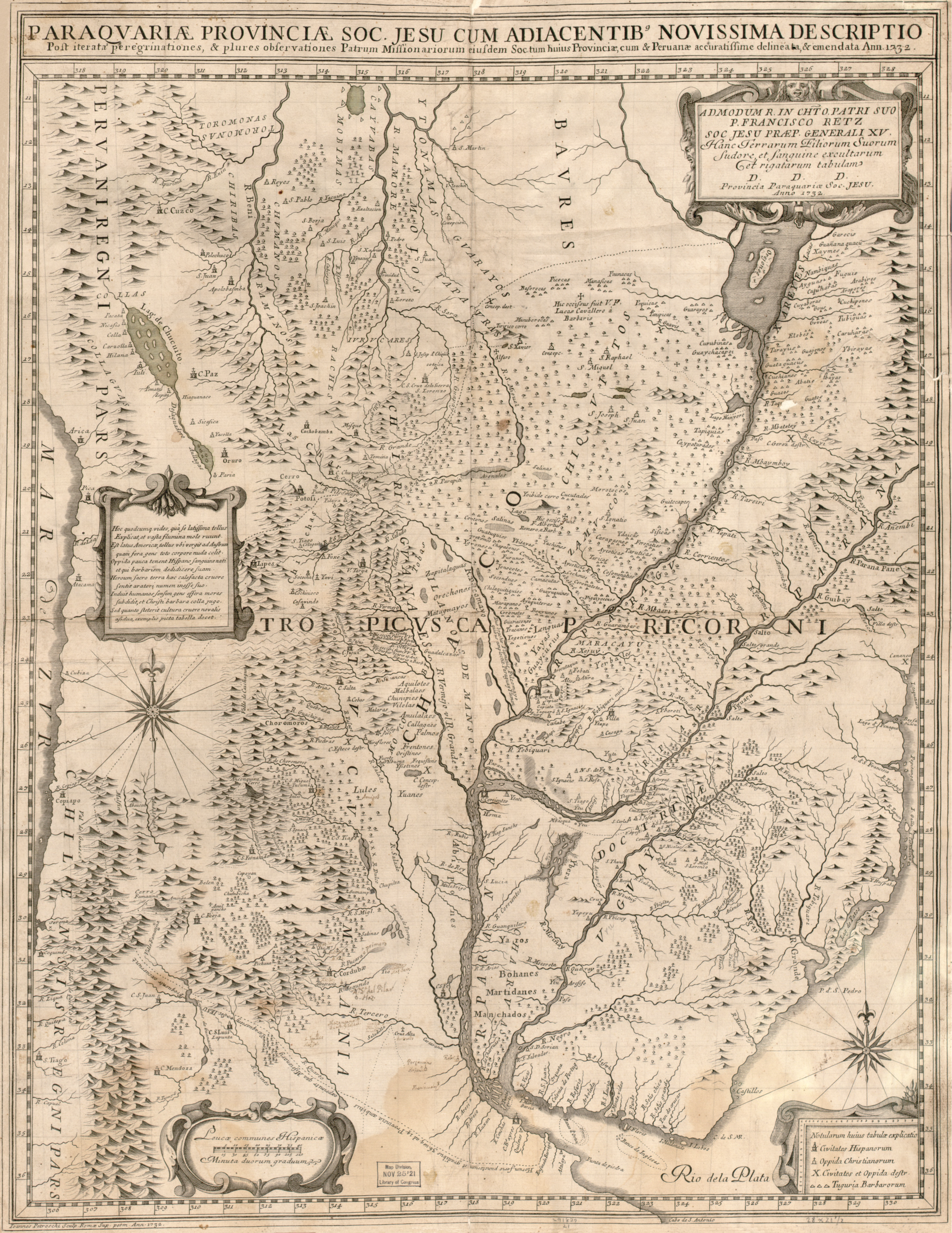
English: Map (66 x 52 cm) in Latin, with some place names in Spanish, showing the Jesuit province of Paraguay and neighbouring areas, with the main missions and missionary journeys. The map was made in Rome by Giovanni Petroschi (1715-66), and is dedicated to Francisco Retz (1673-1750), Superior General of the Society of Jesus.
Latina: Paraguariæ Provinciæ soc. jesu cum adiacentibg. novissima descriptio : post iteratas peregrinationes & plures observationes patrum missionariorum eiusdem soc. tum huius provinciæ, cum & Peruanæ accuratissime delineata & emendata ann. 1732 / admodum r. in cht. o. patri suo P. Francisco Retz, soc. jesu præp. generali XV, hanc terrarum filiorum suorum sudore et sanguine excultarum et rigatarum tabulam ; D.D.D., provincia paraquariæ soc, jesu, anno 1732 ; Ioannes Petroschi, sculp. Romæ sup. perm., ann. 1732. |
| Date | |
| Source | Library of Congress Geography and Map Division Washington, D.C. 20540-4650 USA [1] |
| Auteur | Giovanni Petroschi |
Conditions d’utilisation
|
Ceci est une reproduction photographique fidèle d'une œuvre d'art originale en deux dimensions. L'œuvre d'art elle-même est dans le domaine public pour la raison suivante :
La position officielle de la Fondation Wikimedia est que « les représentations fidèles des œuvres d'art du domaine public en deux dimensions sont dans le domaine public et les exigences contraires sont une attaque contre le concept même de domaine public ». Pour plus de détails, voir Commons:Quand utiliser le bandeau PD-Art.
Cette reproduction photographique est donc également considérée comme étant élevée dans le domaine public. Merci de noter qu'en fonction des lois locales, la réutilisation de ce contenu peut être interdite ou restreinte dans votre juridiction. Voyez Commons:Reuse of PD-Art photographs. | ||||
Historique du fichier
Cliquer sur une date et heure pour voir le fichier tel qu'il était à ce moment-là.
| Date et heure | Vignette | Dimensions | Utilisateur | Commentaire | |
|---|---|---|---|---|---|
| actuel | 24 avril 2009 à 09:12 | | 3 012 × 3 900 (23,65 Mio) | Yarnalgo | scaled down to below 12 megapixels |
| 24 avril 2009 à 08:32 |  | 6 585 × 8 535 (72,52 Mio) | Bamse | {{Information |Description={{en|1=Map (66 x 52 cm) in Latin, with some place names in Spanish, showing the Jesuit province of Paraguay and neighbouring areas, with the main missions and missionary journeys. The map was made in Rome by Giovanni Petroschi ( |
Utilisation du fichier
La page suivante utilise ce fichier :
Usage global du fichier
Les autres wikis suivants utilisent ce fichier :
- Utilisation sur de.wikipedia.org
- Utilisation sur en.wikipedia.org
- Utilisation sur es.wikipedia.org
- Utilisation sur it.wikipedia.org
- Utilisation sur no.wikipedia.org
- Utilisation sur pt.wikipedia.org
- Utilisation sur ru.wikipedia.org
- Utilisation sur sv.wikipedia.org