Fichier:Kilauea Lava Hazard Map.gif
Pas de plus haute résolution disponible.
Kilauea_Lava_Hazard_Map.gif (359 × 270 pixels, taille du fichier : 18 kio, type MIME : image/gif)
Ce fichier et sa description proviennent de Wikimedia Commons.
Description
| Description |
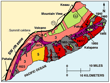
English: Hazard zones for lava flows on Kilauea. The flows erupted since 1800 are shown in gray and dated. Twenty-eight percent of the area encompassed by Zones 1 and 2 on the east half of the volcano has been covered by lava since 1955. The major housing subdivisions on the slopes of the volcano are shown in green. |
| Date | |
| Source | http://pubs.usgs.gov/gip/hazards/kilauea.html |
| Auteur | USGS |
This is the work of the US Government and is in the public domain.
Conditions d’utilisation
Cette image est placée dans le domaine public parce qu'elle contient des éléments issus de l'United States Geological Survey, une agence du Département de l'Intérieur des États-Unis. Pour plus d'information, consultez la politique officielle de copyright de l'USGS (en anglais)
|
Historique du fichier
Cliquer sur une date et heure pour voir le fichier tel qu'il était à ce moment-là.
| Date et heure | Vignette | Dimensions | Utilisateur | Commentaire | |
|---|---|---|---|---|---|
| actuel | 27 mai 2010 à 12:08 | | 359 × 270 (18 kio) | Infanalyst | {{Information |Description={{en|1=Hazard zones for lava flows on Kilauea. The flows erupted since 1800 are shown in gray and dated. Twenty-eight percent of the area encompassed by Zones 1 and 2 on the east half of the volcano has been covered by lava sinc |
Utilisation du fichier
Les 3 pages suivantes utilisent ce fichier :
Usage global du fichier
Les autres wikis suivants utilisent ce fichier :
- Utilisation sur ca.wikipedia.org
- Utilisation sur en.wikipedia.org