Fichier:Koppen-Geiger Map PRY present.svg

Taille de cet aperçu PNG pour ce fichier SVG : 800 × 507 pixels. Autres résolutions : 320 × 203 pixels | 640 × 406 pixels | 1 024 × 650 pixels | 1 280 × 812 pixels | 2 560 × 1 624 pixels | 1 340 × 850 pixels.
Fichier d’origine (Fichier SVG, nominalement de 1 340 × 850 pixels, taille : 585 kio)
Ce fichier et sa description proviennent de Wikimedia Commons.
Description
| Description |
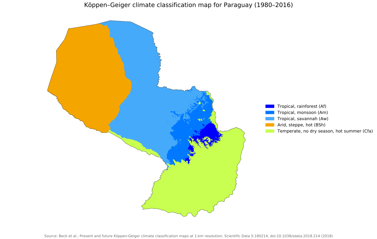
English: Köppen–Geiger climate classification map for Paraguay |
| Date | |
| Source | "Present and future Köppen-Geiger climate classification maps at 1-km resolution". Nature Scientific Data. DOI:10.1038/sdata.2018.214. |
| Auteur | Beck, H.E., Zimmermann, N. E., McVicar, T. R., Vergopolan, N., Berg, A., & Wood, E. F. |
Conditions d’utilisation
Ce fichier est disponible selon les termes de la licence Creative Commons Attribution 4.0 International.
- Vous êtes libre :
- de partager – de copier, distribuer et transmettre cette œuvre
- d’adapter – de modifier cette œuvre
- Sous les conditions suivantes :
- paternité – Vous devez donner les informations appropriées concernant l'auteur, fournir un lien vers la licence et indiquer si des modifications ont été faites. Vous pouvez faire cela par tout moyen raisonnable, mais en aucune façon suggérant que l’auteur vous soutient ou approuve l’utilisation que vous en faites.
| Lieu de la prise de vue | | Voir cet endroit et d’autres images sur : OpenStreetMap |
|---|
Historique du fichier
Cliquer sur une date et heure pour voir le fichier tel qu'il était à ce moment-là.
| Date et heure | Vignette | Dimensions | Utilisateur | Commentaire | |
|---|---|---|---|---|---|
| actuel | 26 novembre 2018 à 07:29 | | 1 340 × 850 (585 kio) | NVergopolan | {{Information |Description={{en| Köppen–Geiger climate classification map for Paraguay}}|date=2018-11-06|source={{cite journal | title=Present and future Köppen-Geiger climate classification maps at 1-km resolution | journal=Nature Scientific Data |doi=10.1038/sdata.2018.214}}|author=Beck, H.E., Zimmermann, N. E., McVicar, T. R., Vergopolan, N., Berg, A., & Wood, E. F.|permission=|other_versions=|other_fields=}}{{Cc-by-4.0}}{{Location|-23.448616025|-58.452575685}}[[Category:Köppen-Geiger Clim... |
Utilisation du fichier
La page suivante utilise ce fichier :
Usage global du fichier
Les autres wikis suivants utilisent ce fichier :
- Utilisation sur af.wikipedia.org
- Utilisation sur bg.wikipedia.org
- Utilisation sur en.wikipedia.org
- Utilisation sur es.wikipedia.org
- Utilisation sur id.wikipedia.org
- Utilisation sur ka.wikipedia.org
- Utilisation sur pt.wikipedia.org
- Utilisation sur sl.wikipedia.org