Fichier:Kuunga2.jpg

Taille de cet aperçu : 764 × 600 pixels. Autres résolutions : 306 × 240 pixels | 612 × 480 pixels | 1 000 × 785 pixels.
Fichier d’origine (1 000 × 785 pixels, taille du fichier : 215 kio, type MIME : image/jpeg)
Ce fichier et sa description proviennent de Wikimedia Commons.
Description

|
Ce fichier a été remplacé par File:Kuunga2.png. Il est recommandé d’utiliser l’autre fichier. La suppression des fichiers remplacés requiert un accord.
|

|
| Description |
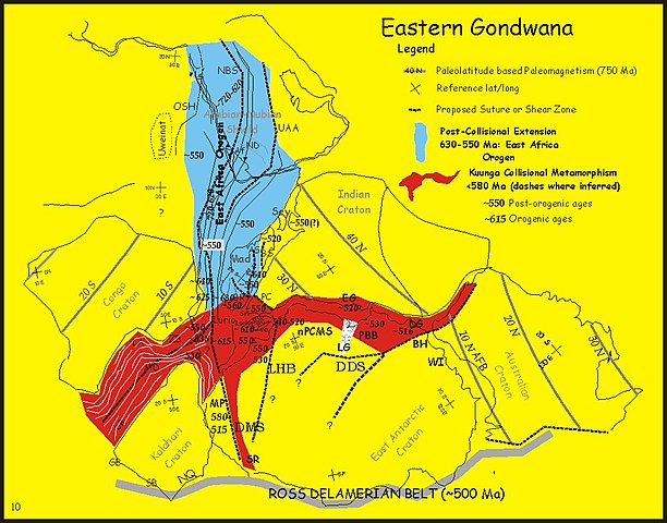
English: Paleotectonic map of eastern Gondwana with the Pan-African and/or circum-Antarctic orogenic (“mobile”) belts highlighted by age differences (See Fitzsimons, 2000a, cited in Meert, 2003, see source data below). Meaning of abbreviations: Af = Afif terrane (Saudi Arabia); AFB = Albany-Fraser Belt (Australia); AS = Angavo shear zone (Madagascar); BH = Bunger Hills (Antarctica); BR = Bongolava-Ranotsara shear zone (Madagascar); BS = Betsimisaraka suture zone (Madagascar); DB = Damara Belt (Africa); DDS = Darling-Denman suture (Antarctica - Australia); DG = Denman Glacier (Antarctica); DMS = Dronning Maud suture (Antarctica); EG = Eastern Ghats (India); GB = Gariep Belt (Africa); HC = Highland Complex (Sri Lanka); LA = Lufilian Arc (Africa); LG = Lambert Graben (Antarctica); LHB = Lützow-Holm Belt (Antarctica); MD = Mwembeshi Dislocation (Africa); MP = Maud Province (Antarctica); NBS = Nabitah Suture (Arabia); nPCSM = Northern Prince Charles Mountains (Antarctica); NQ = Namaqua Belt (Africa); OSH = Onib-Sol Hamed suture (Arabia); PBB = Prydz Bay Belt (Antarctica); PC = Paughat-Cauvery (India); SB = Saldania Belt (Africa); SR = Shackelton Range (Antarctica) ; UAA = Urd Al Amar suture (Arabia); VC = Vijayan Complex (Sri Lanka); WC = Wanni Complex (Sri Lanka); WI = Windmill Islands (Antarctica); ZB = Zambezi Belt (Africa). |
| Date | 6 mars 2006 (date de téléversement originale) |
| Source |
Adapted from fig 2 in: Joseph G. Meert (2003): A synopsis of events related to the assembly of eastern Gondwana. Tectonophysics 362(1–4; Special Issue Paleomagnetism Applied to Tectonics. A tribute to Rob Van der Voo.):1–40, doi:10.1016/S0040-1951(02)00629-7 (manuscript available at UFL). The editor is the author of the above paper and has modified the figure included in the paper. Originally uploaded to the English Wikipedia by Jmeert. |
| Auteur | Jmeert |
| Autorisation (Réutilisation de ce fichier) |
Released into the public domain (by the author). |
Conditions d’utilisation
| |
Cette image a été (ou est ici-même) mise à disposition dans le domaine public par son auteur, Jmeert dans le projet anglais Wikimedia Commons. Ceci s'applique partout dans le monde. Au cas où cela n'est pas possible légalement : |
Journal des téléversements d’origine
La page de description originale était ici. Tous les noms d'utilisateur qui suivent se rapportent à en.wikipedia.
- 2006-03-06 14:15 Jmeert 1000×785×8 (220296 bytes) http://www.clas.ufl.edu/users/jmeert/kuunga.jpg adapted from: Meert, J.G., A synopsis of events related to the assembly of eastern Gondwana, Tectonophysics, 362, 1-40 The editor is the author of the above paper and has modified the figure included in t
Historique du fichier
Cliquer sur une date et heure pour voir le fichier tel qu'il était à ce moment-là.
| Date et heure | Vignette | Dimensions | Utilisateur | Commentaire | |
|---|---|---|---|---|---|
| actuel | 29 février 2008 à 12:16 | | 1 000 × 785 (215 kio) | File Upload Bot (Magnus Manske) | {{BotMoveToCommons|en.wikipedia}} {{Information |Description={{en|http://www.clas.ufl.edu/users/jmeert/kuunga.jpg adapted from: Meert, J.G., A synopsis of events related to the assembly of eastern Gondwana, Tectonophysics, 362, 1-40 The editor is the |
Utilisation du fichier
Aucune page n’utilise ce fichier.