Fichier d’origine(2 152 × 2 196 pixels, taille du fichier : 3,58 Mio, type MIME : image/jpeg)

Ce fichier et sa description proviennent de Wikimedia Commons.

Description

Description
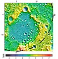
English: Peary Crater (diameter 73 km), located near the lunar north pole, has been a subject of interest for many lunar scientists for years. In the 1990's NASA's Clementine mission imaged the crater, and scientists identified regions surrounding Peary that they suspect remain constantly in daylight throughout the 28 day lunar cycle. However parts of Peary's interior remain in permanent shadow at all times, providing only limited views of its contents. Topographical data from LOLA reveal details hidden in permanently shadowed regions, like those in Peary, that visible light cameras cannot easily image.
Date
Source NASA: https://lola.gsfc.nasa.gov/images/weekly/peary.jpg
Auteur NASA Lunar Orbital Laser Altimeter (LOLA) project

Lunar Polar Regions

Conditions d’utilisation

Public domain Ce fichier provient de la NASA. Sauf exception, les documents créés par la NASA ne sont pas soumis à copyright. Pour plus d'informations, voir la politique de copyright de la NASA.
Attention :

Légendes

Ajoutez en une ligne la description de ce que représente ce fichier

Éléments décrits dans ce fichier

dépeint

Historique du fichier

Cliquer sur une date et heure pour voir le fichier tel qu'il était à ce moment-là.

Date et heureVignetteDimensionsUtilisateurCommentaire
actuel22 mai 2018 à 21:04Vignette pour la version du 22 mai 2018 à 21:042 152 × 2 196 (3,58 Mio)Geoffrey.landisUser created page with UploadWizard

La page suivante utilise ce fichier :

Usage global du fichier

Les autres wikis suivants utilisent ce fichier :

Métadonnées