Fichier:Lagoons and Reefs of New Caledonia May 10, 2001.jpg

Taille de cet aperçu : 800 × 600 pixels. Autres résolutions : 320 × 240 pixels | 640 × 480 pixels | 1 024 × 768 pixels | 1 280 × 960 pixels | 2 560 × 1 920 pixels | 4 000 × 3 000 pixels.
Fichier d’origine (4 000 × 3 000 pixels, taille du fichier : 5,58 Mio, type MIME : image/jpeg)
Ce fichier et sa description proviennent de Wikimedia Commons.
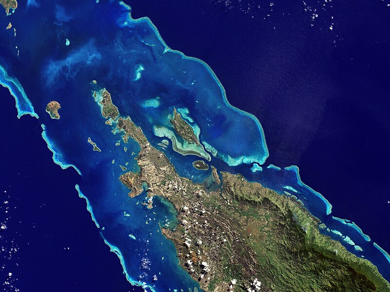
| Description | NASA’s Landsat 7 satellite captured this image of Île Balabio, off the northern tip of Grande Terra, New Caledonia’s main island. In this natural-color image, the islands appear in shades of green and brown—mixtures of vegetation and bare ground. The surrounding waters range in color from pale aquamarine to deep blue, and the color differences result from varying depths. Over coral reef ridges and sand bars, the water is shallowest and palest in color. | |||||
| Date | ||||||
| Source | Earth Observatory | |||||
| Auteur | the Enhanced Thematic Mapper Plus on NASA’s Landsat 7 satellite, Jesse Allen, Michon Scott. | |||||
| Autorisation (Réutilisation de ce fichier) |
|

Historique du fichier
Cliquer sur une date et heure pour voir le fichier tel qu'il était à ce moment-là.
| Date et heure | Vignette | Dimensions | Utilisateur | Commentaire | |
|---|---|---|---|---|---|
| actuel | 27 janvier 2013 à 03:05 | | 4 000 × 3 000 (5,58 Mio) | Slick-o-bot | Bot: convert to a non-interlaced jpeg (see bug #17645) |
| 27 juillet 2008 à 20:22 |  | 4 000 × 3 000 (5,02 Mio) | CarolSpears | {{Information |Description=NASA’s Landsat 7 satellite captured this image of Île Balabio, off the northern tip of Grande Terra, New Caledonia’s main island. In this natural-color image, the islands appear in shades of green and brown—mixtures of ve |
Utilisation du fichier
Les 5 pages suivantes utilisent ce fichier :
Usage global du fichier
Les autres wikis suivants utilisent ce fichier :
- Utilisation sur ar.wikipedia.org
- Utilisation sur ast.wikipedia.org
- Utilisation sur ca.wikipedia.org
- Utilisation sur ceb.wikipedia.org
- Utilisation sur cs.wikipedia.org
- Utilisation sur de.wikipedia.org
- Utilisation sur en.wikipedia.org
- Utilisation sur en.wikibooks.org
- Utilisation sur es.wikipedia.org
- Utilisation sur eu.wikipedia.org
- Utilisation sur fi.wikipedia.org
- Utilisation sur gl.wikipedia.org
- Utilisation sur he.wikipedia.org
- Utilisation sur hr.wikipedia.org
- Utilisation sur id.wikipedia.org
- Utilisation sur it.wikipedia.org
- Utilisation sur ka.wikipedia.org
- Utilisation sur ko.wikipedia.org
- Utilisation sur lt.wikipedia.org
- Utilisation sur lv.wikipedia.org
- Utilisation sur mt.wikipedia.org
- Utilisation sur ne.wikipedia.org
- Utilisation sur nl.wikipedia.org
- Utilisation sur no.wikipedia.org
- Utilisation sur pl.wikipedia.org
- Utilisation sur pt.wikipedia.org
Voir davantage sur l’utilisation globale de ce fichier.