Fichier:Lake Shore and Michigan Southern Railway system map (1914).svg

Taille de cet aperçu PNG pour ce fichier SVG : 800 × 457 pixels. Autres résolutions : 320 × 183 pixels | 640 × 366 pixels | 1 024 × 585 pixels | 1 280 × 731 pixels | 2 560 × 1 463 pixels | 1 120 × 640 pixels.
Fichier d’origine (Fichier SVG, nominalement de 1 120 × 640 pixels, taille : 6,54 Mio)
Ce fichier et sa description proviennent de Wikimedia Commons.
.svg?uselang=fr)
Description
| Description |
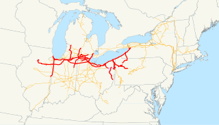
This is a map of the Lake Shore and Michigan Southern Railway as of 1914 drawn on the New York Central system as of 1918, with trackage rights in purple. Email me if you would like a copy of the GIS data I created (modified from Bureau of Transportation Statistics North American Transportation Atlas Data) or if you see any errors. This map does not include the Cleveland, Cincinnati, Chicago and St. Louis Railway system, which the LS&MS controlled but did not operate. See Image:Cleveland, Cincinnati, Chicago and St. Louis Railway system map (1918).svg for those lines. It also does not include the New York, Chicago and St. Louis Railroad, which the LS&MS and NYC controlled until 1916. |
| Date | 13 novembre 2008 (date de téléversement originale) |
| Source | La source n’a pas pu être reconnue automatiquement. « Travail personnel » supposé (étant donné la revendication de droit d’auteur). |
| Auteur | L’auteur n’a pas pu être identifié automatiquement. Il est supposé qu'il s'agit de : NE2 (étant donné la revendication de droit d’auteur). |
.svg)
Conditions d’utilisation
| Moi, propriétaire des droits d’auteur sur cette œuvre, la place dans le domaine public. Ceci s'applique dans le monde entier. Dans certains pays, ceci peut ne pas être possible ; dans ce cas : J’accorde à toute personne le droit d’utiliser cette œuvre dans n’importe quel but, sans aucune condition, sauf celles requises par la loi. |
Historique du fichier
Cliquer sur une date et heure pour voir le fichier tel qu'il était à ce moment-là.
| Date et heure | Vignette | Dimensions | Utilisateur | Commentaire | |
|---|---|---|---|---|---|
| actuel | 13 novembre 2008 à 18:37 | | 1 120 × 640 (6,54 Mio) | NE2 | == Summary == This is a map of the Lake Shore and Michigan Southern Railway drawn on the New York Central system as of 1914, with trackage rights in purple. Email me if you would like a copy of the GIS data |
Utilisation du fichier
La page suivante utilise ce fichier :
Usage global du fichier
Les autres wikis suivants utilisent ce fichier :
- Utilisation sur en.wikipedia.org
- Utilisation sur www.wikidata.org
.svg)