Fichier:Lituya Bay rockslide 2.jpg
Taille de cet aperçu : 745 × 600 pixels. Autres résolutions : 298 × 240 pixels | 596 × 480 pixels | 750 × 604 pixels.
Fichier d’origine (750 × 604 pixels, taille du fichier : 109 kio, type MIME : image/jpeg)
Ce fichier et sa description proviennent de Wikimedia Commons.
Description
| Description |
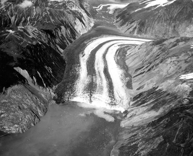
English: Photo looking down the Fairweather Fault Trench at the head of Lituya Bay. The front of Lituya Glacier with lateral and medial moraines is seen terminating in Gilbert Inlet. The cliff where the rockslide originated is on the right side of Gilbert Inlet. The opposite valley wall on the left side of Gilbert Inlet received the full force of the big wave, stripping it of soil and trees. Photo by D.J. Miller, United States Geological Survey. |
| Date | été 1958 |
| Source | USGS via [1] |
| Auteur | D.J. Miller, United States Geological Survey |
Conditions d’utilisation
| Cette image ou ce document multimédia contient des éléments basés sur une œuvre d'un employé du United States Department of the Interior, créé dans le cadre des tâches officielles de cette personne. En tant qu'œuvre du Gouvernement fédéral des États-Unis, une telle œuvre se trouve dans le domaine public aux États-Unis. Voir la politique en matière de droits d'auteur du Department of the Interior pour plus d'informations. |  |
Historique du fichier
Cliquer sur une date et heure pour voir le fichier tel qu'il était à ce moment-là.
| Date et heure | Vignette | Dimensions | Utilisateur | Commentaire | |
|---|---|---|---|---|---|
| actuel | 16 juillet 2008 à 21:44 | | 750 × 604 (109 kio) | Eleland | == Summary == {{Information |Description={{en|1=Photo looking down the Fairweather Fault Trench at the head of Lituya Bay. The front of Lituya Glacier with lateral and medial moraines is seen terminating in Gilbert Inlet. The cliff where the rockslide ori |
Utilisation du fichier
Les 3 pages suivantes utilisent ce fichier :
Usage global du fichier
Les autres wikis suivants utilisent ce fichier :
- Utilisation sur ceb.wikipedia.org
- Utilisation sur cs.wikipedia.org
- Utilisation sur fi.wikipedia.org
- Utilisation sur he.wikipedia.org
- Utilisation sur nn.wikipedia.org
- Utilisation sur www.wikidata.org