Fichier:Macedonia topography-en.svg

Fichier d’origine (Fichier SVG, nominalement de 920 × 652 pixels, taille : 4,25 Mio)
Ce fichier et sa description proviennent de Wikimedia Commons.
Description
| Description |
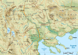
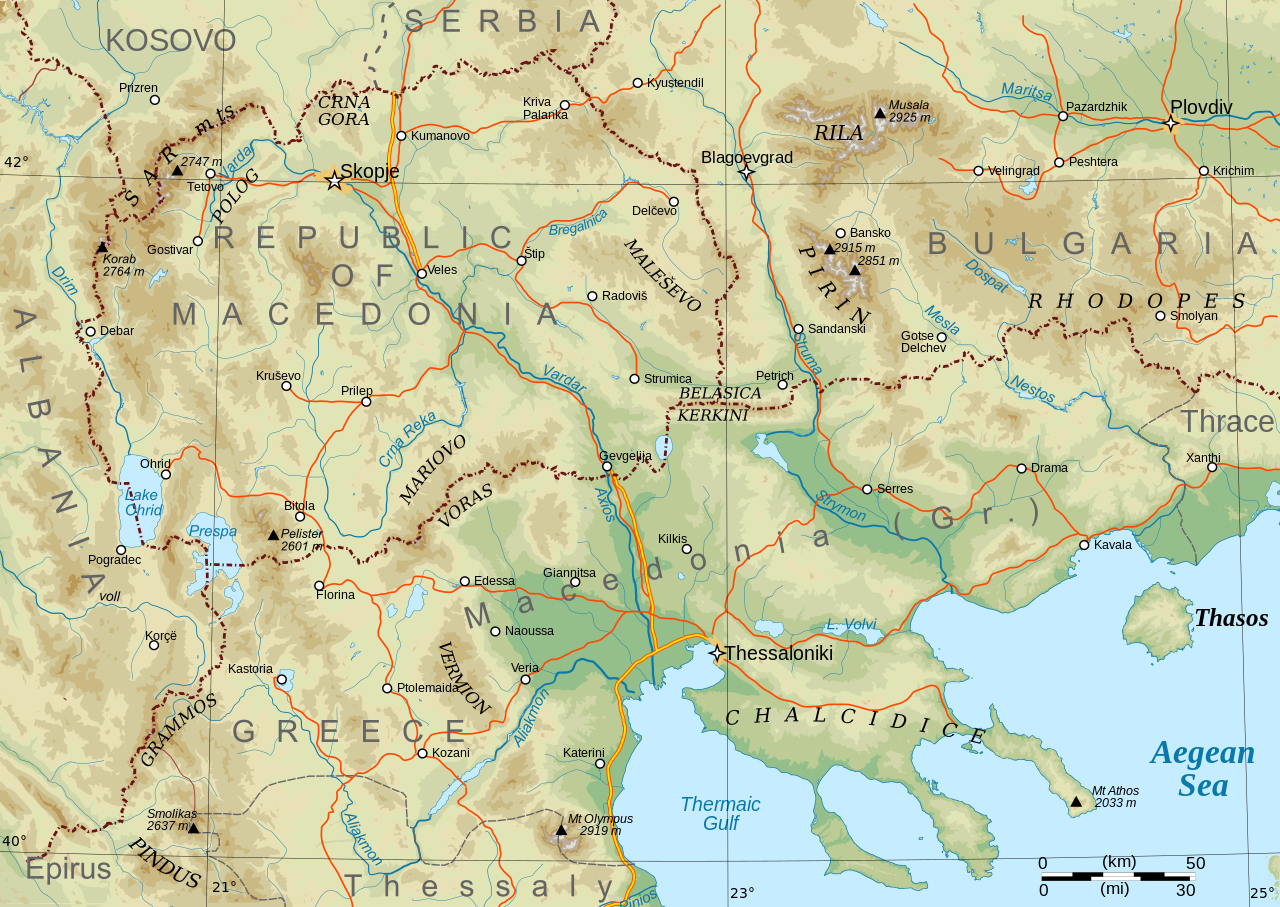
English: Topographical map of Macedonia, i.e. the Republic of North Macedonia, the Greek province of Macedonia, and southwestern Bulgaria. |
| Date | |
| Source | Travail personnel |
| Auteur | Future Perfect at Sunrise |
| Autres versions |
Œuvres dérivées de ce fichier : Macedonia topography-He.svg This file version has non-horizontal text labels converted to paths, to ensure correct display with renderers that don't do advanced text layout along paths. If you want to modify or translate this map, please work on the basis of File:Macedonia topography (texts).svg, which has the labels preserved as texts (but will only display correctly in Inkscape).
|

.svg)
Made with GRASS GIS and Inkscape software from public-domain geo data (SRTM3, SWBD, VMAP0). See the excellent tutorials by User:Sting at w:fr:Wikipédia:Atelier graphique/Didacticiels cartographiques/Didacticiels pour la cartographie numérique géoréférencée. Relief levels vectorised and exported to SVG; relief shading is embedded bitmap graphics.
Geographical extent: c. 20.5E to 25.3E, 39.8N to 42.4N; map projection: Lambert conformal conic with standard parallels 40 and 42N, standard meridian 23E. Scale approx. 1:1,600,000 at nominal SVG size.
Conditions d’utilisation
| Moi, propriétaire des droits d’auteur sur cette œuvre, la place dans le domaine public. Ceci s'applique dans le monde entier. Dans certains pays, ceci peut ne pas être possible ; dans ce cas : J’accorde à toute personne le droit d’utiliser cette œuvre dans n’importe quel but, sans aucune condition, sauf celles requises par la loi. |
Historique du fichier
Cliquer sur une date et heure pour voir le fichier tel qu'il était à ce moment-là.
| Date et heure | Vignette | Dimensions | Utilisateur | Commentaire | |
|---|---|---|---|---|---|
| actuel | 31 janvier 2009 à 10:29 | | 920 × 652 (4,25 Mio) | Future Perfect at Sunrise | some additions and corrections |
| 23 janvier 2009 à 23:49 |  | 920 × 652 (4,01 Mio) | Future Perfect at Sunrise | {{Information |Description={{en|1=Topographical map of geographic Macedonia}} |Source=Own work by uploader |Author=Future Perfect at Sunrise |Date=23 January 2009 |Permission= |other_versions= }} <!--{{ImageUpload|full} |
Utilisation du fichier
Les 6 pages suivantes utilisent ce fichier :
Usage global du fichier
Les autres wikis suivants utilisent ce fichier :
- Utilisation sur ang.wikipedia.org
- Utilisation sur ar.wikipedia.org
- Utilisation sur ca.wikipedia.org
- Utilisation sur el.wikipedia.org
- Utilisation sur en.wikipedia.org
- Utilisation sur fa.wikipedia.org
- Utilisation sur fi.wikipedia.org
- Utilisation sur he.wikipedia.org
- Utilisation sur id.wikipedia.org
- Utilisation sur it.wikipedia.org
- Utilisation sur ja.wikipedia.org
- Utilisation sur ms.wikipedia.org
- Utilisation sur pl.wikipedia.org
- Utilisation sur sq.wikipedia.org
- Utilisation sur sr.wikipedia.org
- Utilisation sur sw.wikipedia.org
- Utilisation sur trv.wikipedia.org
- Utilisation sur war.wikipedia.org
- Utilisation sur zh-yue.wikipedia.org
- Utilisation sur zh.wikipedia.org