Fichier:Map Praying Mantis.png
Pas de plus haute résolution disponible.
Map_Praying_Mantis.png (517 × 378 pixels, taille du fichier : 152 kio, type MIME : image/png)
Ce fichier et sa description proviennent de Wikimedia Commons.
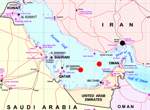
Map of Persian Gulf - marks are approxymate positions of the iranian Oilrigs Sassan (left) and Sirri (right) and the city of Bandar Abbas (black). Both rigs were destroyed while Operation Praying Mantis on April 18, 1988
The map is a part of Image:MiddleEast.png, which is marked as:
Subject: Middle East map
Source: NIMA [1] copie d'archive sur Wayback Machine
Ce média est dans le domaine public des États-Unis d’Amérique car son auteur est l’administration américaine comme précisé dans le code fédéral au Titre 17, Chapitre 1, Section 105. Pour en savoir plus : droit d’auteur.
Attention : Ceci ne concerne que le travail du Gouvernement Fédéral et pas celui des États, ou d’une autre subdivision géographique ou politique du pays.
|
 | |
| Ce fichier a été identifié comme étant exempt de restrictions connues liées au droit d’auteur, y compris tous les droits connexes et voisins. | ||
Historique du fichier
Cliquer sur une date et heure pour voir le fichier tel qu'il était à ce moment-là.
| Date et heure | Vignette | Dimensions | Utilisateur | Commentaire | |
|---|---|---|---|---|---|
| actuel | 29 avril 2006 à 22:35 | | 517 × 378 (152 kio) | Schlendrian | Map of Persian Gulf - marks are approxymate positions of the iranian Oilrigs ''Sassan'' (left) and ''Sirri'' (right) and the city of Bandar Abbas (black). Both rigs were destroyed while Operation Praying Mantis on April 18, 1988 The map is a part of [[:I |
Utilisation du fichier
La page suivante utilise ce fichier :
Usage global du fichier
Les autres wikis suivants utilisent ce fichier :
- Utilisation sur ca.wikipedia.org
- Utilisation sur en.wikipedia.org
- Utilisation sur fa.wikipedia.org
- Utilisation sur sv.wikipedia.org