Fichier:Map of Еastern Thrace borders Bulgaria Ottoman empire 1912 1919-bg.svg

Taille de cet aperçu PNG pour ce fichier SVG : 671 × 599 pixels. Autres résolutions : 269 × 240 pixels | 537 × 480 pixels | 860 × 768 pixels | 1 146 × 1 024 pixels | 2 292 × 2 048 pixels | 1 679 × 1 500 pixels.
Fichier d’origine (Fichier SVG, nominalement de 1 679 × 1 500 pixels, taille : 10,55 Mio)
Ce fichier et sa description proviennent de Wikimedia Commons.
Description
| Description |
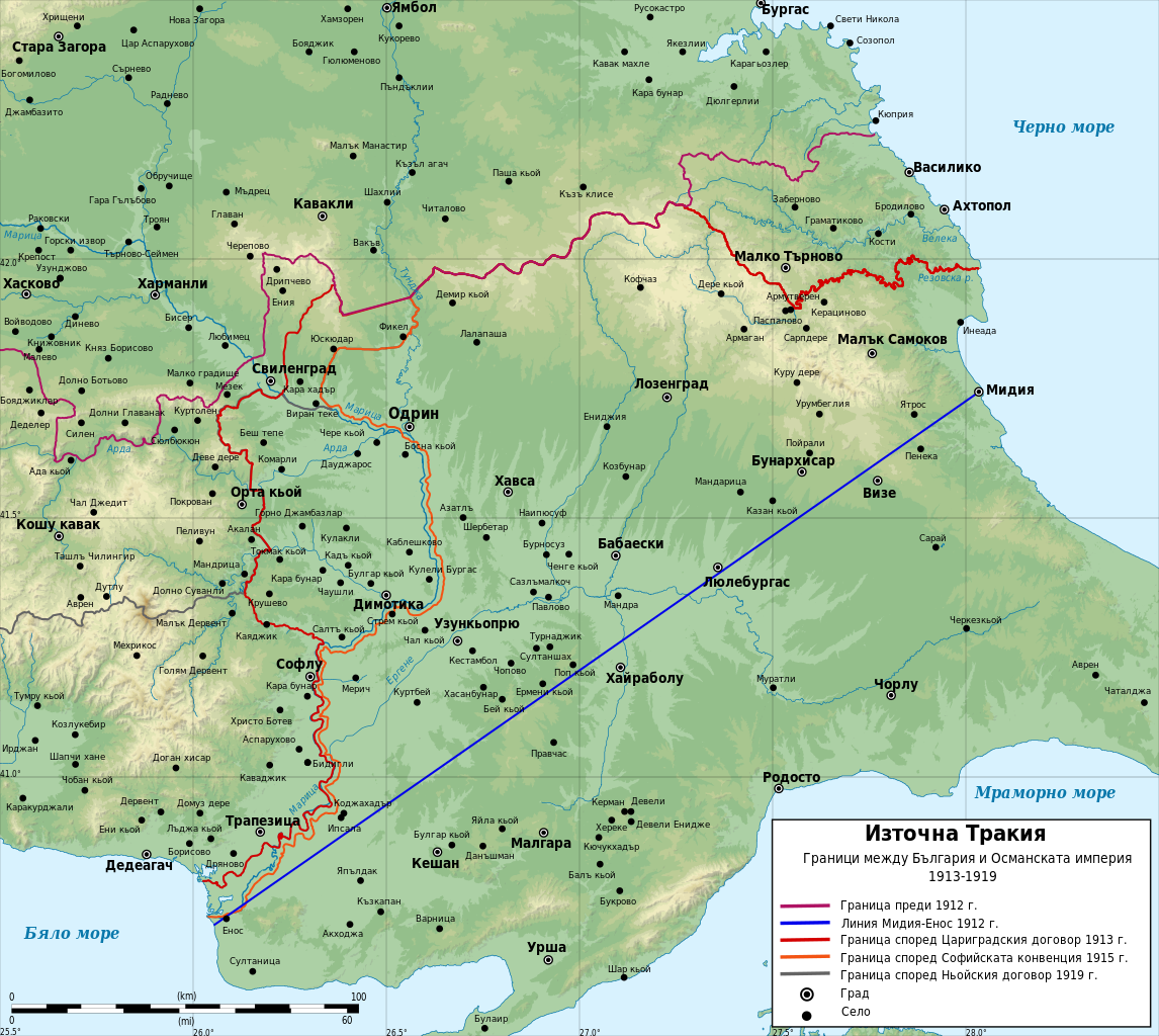
English: Historical map of borders between Bulgaria and Ottoman Empire in Eastern Thrace between 1912 and 1919. In Bulgarian
Български: Историческа Карта на Източна Тракия с границите между България и Османската империя между 1912 и 1919 г. На български
Мар information:
|
| Date | |
| Source |
Travail personnel Data:
|
| Auteur | Ikonact |
Conditions d’utilisation
Moi, en tant que détenteur des droits d’auteur sur cette œuvre, je la publie sous les licences suivantes :
Ce fichier est disponible selon les termes de la licence Creative Commons Attribution – Partage dans les Mêmes Conditions 3.0 (non transposée).
- Vous êtes libre :
- de partager – de copier, distribuer et transmettre cette œuvre
- d’adapter – de modifier cette œuvre
- Sous les conditions suivantes :
- paternité – Vous devez donner les informations appropriées concernant l'auteur, fournir un lien vers la licence et indiquer si des modifications ont été faites. Vous pouvez faire cela par tout moyen raisonnable, mais en aucune façon suggérant que l’auteur vous soutient ou approuve l’utilisation que vous en faites.
- partage à l’identique – Si vous modifiez, transformez, ou vous basez sur cette œuvre, vous devez distribuer votre contribution sous la même licence ou une licence compatible avec celle de l’original.

|
Vous avez la permission de copier, distribuer et modifier ce document selon les termes de la GNU Free Documentation License version 1.2 ou toute version ultérieure publiée par la Free Software Foundation, sans sections inaltérables, sans texte de première page de couverture et sans texte de dernière page de couverture. Un exemplaire de la licence est inclus dans la section intitulée GNU Free Documentation License. |
Vous pouvez choisir l’une de ces licences.
Historique du fichier
Cliquer sur une date et heure pour voir le fichier tel qu'il était à ce moment-là.
| Date et heure | Vignette | Dimensions | Utilisateur | Commentaire | |
|---|---|---|---|---|---|
| actuel | 9 janvier 2024 à 23:41 | | 1 679 × 1 500 (10,55 Mio) | Ikonact | Further correction of the 1915 border near Enos |
| 9 janvier 2024 à 23:10 |  | 1 679 × 1 500 (10,55 Mio) | Ikonact | Correction of teh 1915 border | |
| 8 mars 2014 à 09:06 |  | 1 679 × 1 500 (10,55 Mio) | Ikonact | {{Information |Description ={{en|1=Historical map of borders between Bulgaria and Ottoman Empire in Eastern Thrace between 1912 and 1919. In Bulgarian}} {{bg|1=Историческа Карта на [[:bg:Източна Тра... |
Utilisation du fichier
Aucune page n’utilise ce fichier.
Usage global du fichier
Les autres wikis suivants utilisent ce fichier :
- Utilisation sur bg.wikipedia.org
- Utilisation sur ru.wikipedia.org
- Utilisation sur tr.wikipedia.org