Fichier:Map of Churchill Harbour by Jens Munck 1624 (1897).jpg

Fichier d’origine (2 216 × 1 679 pixels, taille du fichier : 2,36 Mio, type MIME : image/jpeg)
Ce fichier et sa description proviennent de Wikimedia Commons.
Description
| Description |
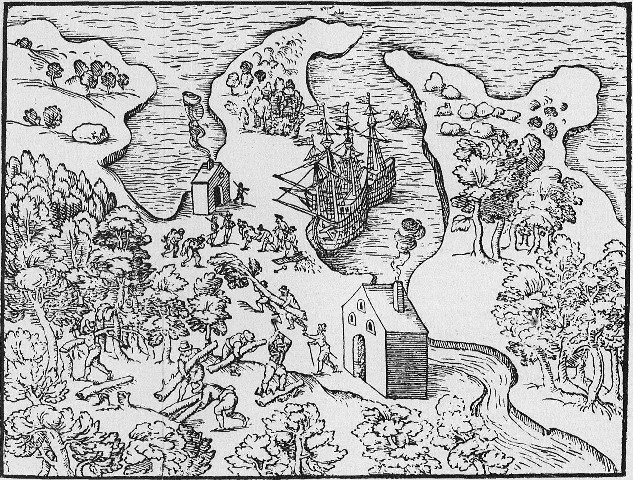
Munck, Jens. [Map of Churchill Harbour 1624] [facisimle]. [1:107,712]. In: C.C.A. Gosch. The Expedition of Captain Jens Munk to Hudson's Bay in Search of a North-West Passage in 1619-20. London: Hakluyt Society, 1897. As reproduced by, Hakluyt Society, Danish Arctic Expeditions, 1605 to 1620, Book II, vol. 97. Munck's wintering place is depicted in this interesting woodcut, which combines pictorial representation of the countryside and of activities, with a stylized map of Churchill harbour. This is the first large-scale map of a Manitoba locale. Munck's two ships are anchored off their wintering place on the west side of the harbour. Two beacons are being stoked with logs cut from the nearby forests, two sailors return from the hunt with their kill over their shoulders, and one unfortunate crew member is being prepared for burial, likely one of the victims of the scurvy. The felling of timber, a continuous necessity, is the beginning of the process which was followed by all later inhabitants, and which denuded the countryside for miles back from the site. The shape of the harbour with its encircling arms is properly, though crudely, represented and its axis is correctly oriented north to south. (Warkentin and Ruggles. Historical Atlas of Manitoba. map 4, p. 24) Original manuscript and map in University Library, Copenhagen, (MS. Additamenta, No. 184) |
||
| Date | |||
| Source | Map of Churchill Harbour by Jens Munck 1624 (1897) | ||
| Auteur | Manitoba Historical Maps | ||
| Autres versions |
|
_-_5_fig_3_-_Winter_Harbour_at_Churchill_River_-_1_full.png)
.jpg?uselang=fr)
| Lieu de la prise de vue | | Voir cet endroit et d’autres images sur : OpenStreetMap |
|---|
.jpg¶ms=058.752531_N_-094.236602_E_globe:Earth_type:camera_source:Flickr_&language=fr)
Conditions d’utilisation
- Vous êtes libre :
- de partager – de copier, distribuer et transmettre cette œuvre
- d’adapter – de modifier cette œuvre
- Sous les conditions suivantes :
- paternité – Vous devez donner les informations appropriées concernant l'auteur, fournir un lien vers la licence et indiquer si des modifications ont été faites. Vous pouvez faire cela par tout moyen raisonnable, mais en aucune façon suggérant que l’auteur vous soutient ou approuve l’utilisation que vous en faites.
| Cette image a été originellement postée sur Flickr par Manitoba Historical Maps à l'adresse https://www.flickr.com/photos/11496488@N07/1128393743. Elle a été passée en revue le 25 juin 2011 par le robot FlickreviewR, qui a confirmé qu'elle se trouvait sous licence cc-by-2.0. |
Historique du fichier
Cliquer sur une date et heure pour voir le fichier tel qu'il était à ce moment-là.
| Date et heure | Vignette | Dimensions | Utilisateur | Commentaire | |
|---|---|---|---|---|---|
| actuel | 25 juin 2011 à 17:17 | | 2 216 × 1 679 (2,36 Mio) | FlickreviewR | Replacing image by its original image from Flickr |
| 25 juin 2011 à 16:44 |  | 500 × 379 (153 kio) | Geo Swan | {{Information |Description=Munck, Jens. [Map of Churchill Harbour 1624] [facisimle]. [1:107,712]. In: C.C.A. Gosch. The Expedition of Captain Jens Munk to Hudson's Bay in Search of a North-West Passage in 1619-20. London: Hakluyt Society, 1897. As reprodu |
Utilisation du fichier
La page suivante utilise ce fichier :
Usage global du fichier
Les autres wikis suivants utilisent ce fichier :
- Utilisation sur ca.wikipedia.org
- Utilisation sur nl.wikipedia.org
.jpg)