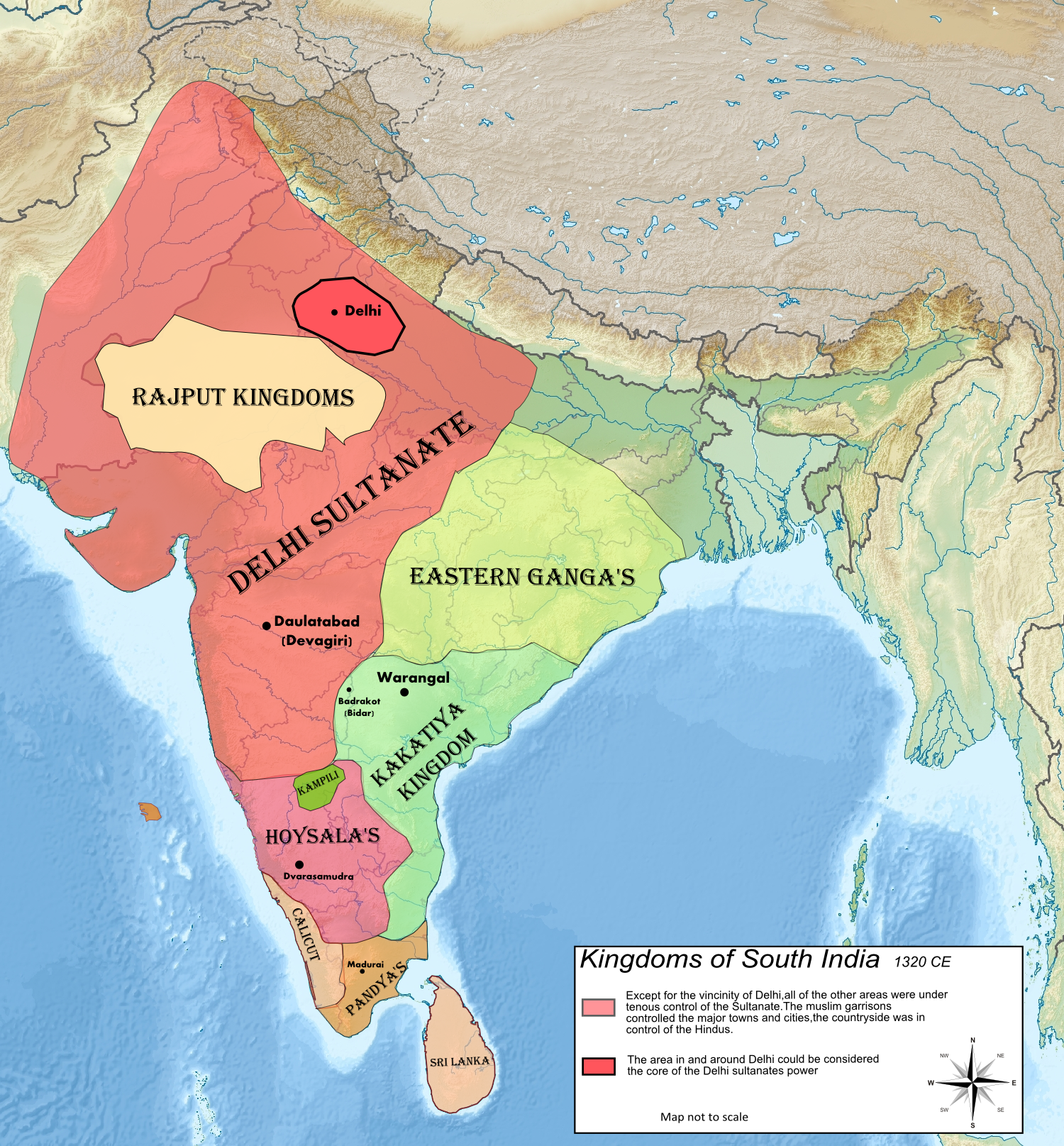
Fichier:Map of Kampili kingdom.png
Taille de cet aperçu : 557 × 600 pixels. Autres résolutions : 223 × 240 pixels | 446 × 480 pixels | 713 × 768 pixels | 951 × 1 024 pixels | 1 500 × 1 615 pixels.
Fichier d’origine (1 500 × 1 615 pixels, taille du fichier : 3,72 Mio, type MIME : image/png)
Ce fichier et sa description proviennent de Wikimedia Commons.
Description
| Description | |
| Date | |
| Source | Travail personnel |
| Auteur | Tulika and Satvik |
Conditions d’utilisation
Moi, en tant que détenteur des droits d’auteur sur cette œuvre, je la publie sous la licence suivante :
Ce fichier est sous la licence Creative Commons Attribution – Partage dans les Mêmes Conditions 4.0 International.
- Vous êtes libre :
- de partager – de copier, distribuer et transmettre cette œuvre
- d’adapter – de modifier cette œuvre
- Sous les conditions suivantes :
- paternité – Vous devez donner les informations appropriées concernant l'auteur, fournir un lien vers la licence et indiquer si des modifications ont été faites. Vous pouvez faire cela par tout moyen raisonnable, mais en aucune façon suggérant que l’auteur vous soutient ou approuve l’utilisation que vous en faites.
- partage à l’identique – Si vous modifiez, transformez, ou vous basez sur cette œuvre, vous devez distribuer votre contribution sous la même licence ou une licence compatible avec celle de l’original.
Historique du fichier
Cliquer sur une date et heure pour voir le fichier tel qu'il était à ce moment-là.
| Date et heure | Vignette | Dimensions | Utilisateur | Commentaire | |
|---|---|---|---|---|---|
| actuel | 23 mars 2022 à 11:48 | | 1 500 × 1 615 (3,72 Mio) | Okayokin | Reverted to version as of 08:33, 19 December 2020 (UTC) |
| 2 janvier 2022 à 15:33 |  | 3 500 × 3 768 (13,24 Mio) | George.Marlin | Added southern Indian 'little kingdoms' | |
| 19 décembre 2020 à 10:33 |  | 1 500 × 1 615 (3,72 Mio) | Tulika and Satvik | Uploaded own work with UploadWizard |
Utilisation du fichier
La page suivante utilise ce fichier :
Usage global du fichier
Les autres wikis suivants utilisent ce fichier :
- Utilisation sur ar.wikipedia.org
- Utilisation sur en.wikipedia.org
- Utilisation sur it.wikipedia.org
- Utilisation sur kn.wikipedia.org
- Utilisation sur ko.wikipedia.org
- Utilisation sur sat.wikipedia.org
- Utilisation sur www.wikidata.org