Fichier:Map of Knickebein transmitters.svg

Taille de cet aperçu PNG pour ce fichier SVG : 527 × 599 pixels. Autres résolutions : 211 × 240 pixels | 422 × 480 pixels | 676 × 768 pixels | 901 × 1 024 pixels | 1 802 × 2 048 pixels | 658 × 748 pixels.
Fichier d’origine (Fichier SVG, nominalement de 658 × 748 pixels, taille : 112 kio)
Ce fichier et sa description proviennent de Wikimedia Commons.
Description
| Description |
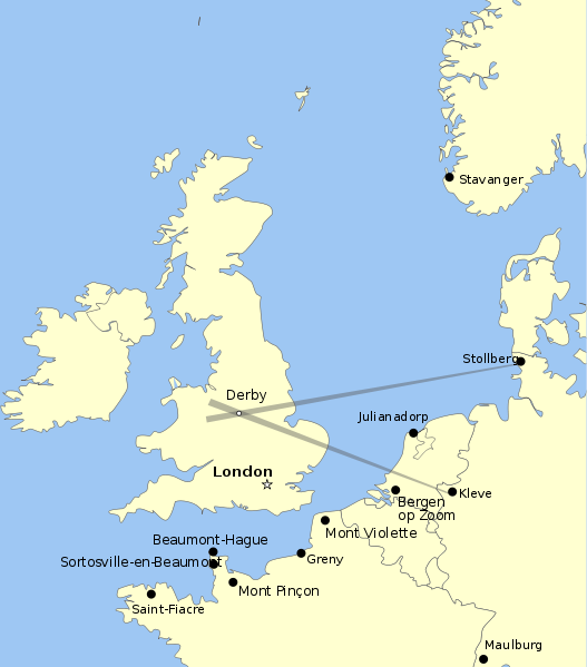
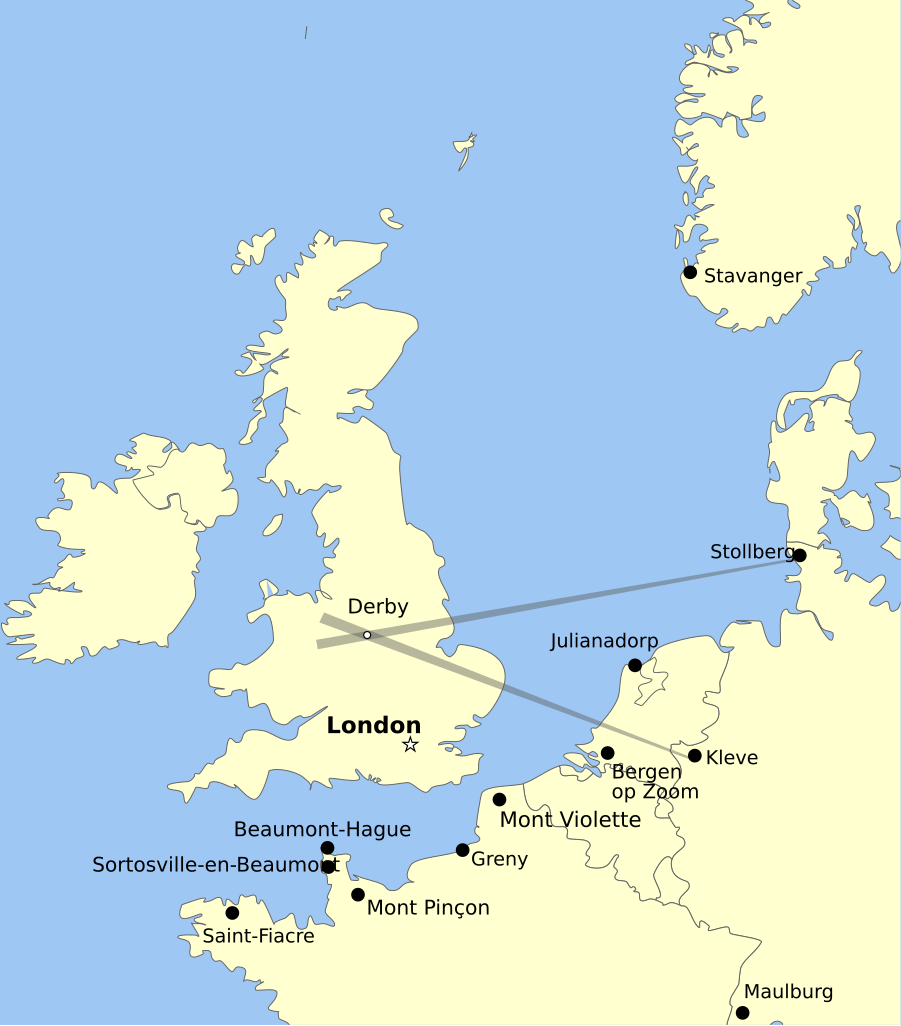
English: Map showing the positions of Knickebein transmitters during the battle of Britain. |
| Date | |
| Source | Travail personnel |
| Auteur | Dahnielson |
Conditions d’utilisation
Moi, en tant que détenteur des droits d’auteur sur cette œuvre, je la publie sous les licences suivantes :
Ce fichier est disponible selon les termes de la licence Creative Commons Attribution – Partage dans les Mêmes Conditions 3.0 (non transposée).
- Vous êtes libre :
- de partager – de copier, distribuer et transmettre cette œuvre
- d’adapter – de modifier cette œuvre
- Sous les conditions suivantes :
- paternité – Vous devez donner les informations appropriées concernant l'auteur, fournir un lien vers la licence et indiquer si des modifications ont été faites. Vous pouvez faire cela par tout moyen raisonnable, mais en aucune façon suggérant que l’auteur vous soutient ou approuve l’utilisation que vous en faites.
- partage à l’identique – Si vous modifiez, transformez, ou vous basez sur cette œuvre, vous devez distribuer votre contribution sous la même licence ou une licence compatible avec celle de l’original.

|
Vous avez la permission de copier, distribuer et modifier ce document selon les termes de la GNU Free Documentation License version 1.2 ou toute version ultérieure publiée par la Free Software Foundation, sans sections inaltérables, sans texte de première page de couverture et sans texte de dernière page de couverture. Un exemplaire de la licence est inclus dans la section intitulée GNU Free Documentation License. |
Vous pouvez choisir l’une de ces licences.
Historique du fichier
Cliquer sur une date et heure pour voir le fichier tel qu'il était à ce moment-là.
| Date et heure | Vignette | Dimensions | Utilisateur | Commentaire | |
|---|---|---|---|---|---|
| actuel | 26 août 2011 à 08:47 | | 658 × 748 (112 kio) | Chriusha | Position of K 11 corrected, see Disk |
| 13 mai 2011 à 17:38 |  | 658 × 748 (112 kio) | Hohum | More readable text. | |
| 22 avril 2010 à 00:18 |  | 658 × 748 (113 kio) | Dahnielson | Made the beams nicer, changed the Stollberg label and hopefully fixed the font rendering. Category:Radio navigation Category:Battle of Britain | |
| 21 avril 2010 à 00:14 |  | 658 × 748 (114 kio) | Dahnielson | Added Julianadorp and Bergen op Zoom to map | |
| 20 avril 2010 à 23:50 |  | 658 × 748 (111 kio) | Dahnielson | Added transmitter locations and the Kleve/Stollberg beams targeting Derby as an example. | |
| 20 avril 2010 à 21:19 |  | 658 × 748 (103 kio) | Dahnielson | Reverted to version as of 18:47, 20 April 2010 | |
| 20 avril 2010 à 21:18 |  | 658 × 748 (103 kio) | Dahnielson | Try to fix the font issue. | |
| 20 avril 2010 à 20:47 |  | 658 × 748 (103 kio) | Dahnielson | {{Information |Description={{en|1=Map showing the positions of Knickebein transmitters during the battle of Britain.}} |Source={{own}} |Author=Dahnielson |Date=2010-04-20 |Permission= |other_versions= }} |
Utilisation du fichier
Les 2 pages suivantes utilisent ce fichier :
Usage global du fichier
Les autres wikis suivants utilisent ce fichier :
- Utilisation sur ar.wikipedia.org
- Utilisation sur de.wikipedia.org
- Utilisation sur en.wikipedia.org
- Utilisation sur es.wikipedia.org
- Utilisation sur he.wikipedia.org
- Utilisation sur sk.wikipedia.org