Fichier:Map of Minnesota NA.jpg
Fichier d’origine (1 453 × 1 890 pixels, taille du fichier : 432 kio, type MIME : image/jpeg)
Ce fichier et sa description proviennent de Wikimedia Commons.
Description
| Description |
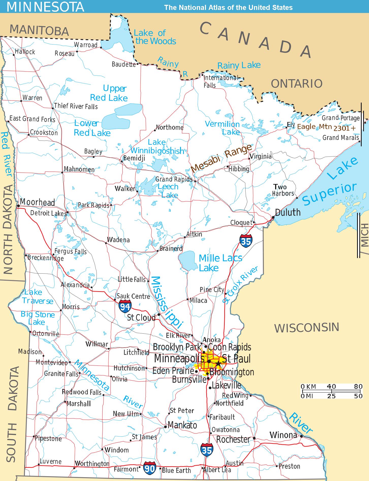
Scalable map of the U.S. state of Minnesota, showing terrain features: hills, lakes, rivers, roads and major towns, in quick photographic format (JPEG) to highlight terrain features. The Mesabi Range, Mount Eagle, and nearby states are labeled; the Interstate icons are enlarged 40%; and major cities are bolded 20%-40% for readability when scaled to 310px display width. The distance scale is shown in miles/kilometers, and labels appear 4x times larger than original in the US National Atlas, at similar display width. Format: Quick JPEG format for photographic quality, extracted/reduced from National-Atlas file of PNG format, 130x times more massive. Names have been enlarged for readability when map is resized smaller. Map is huge and could be reduced more: the original PNG file might crash browsers with many open windows. |
| Date | |
| Source | National Atlas (cropped to extract terrain only, no legend, with several names enlarged/added) |
| Auteur | User:Wikid77 (from National Atlas of the United States) |
| Autres versions |
The map has some related variations:
|


Conditions d’utilisation
Cette carte a été obtenue d'une édition du
National Atlas of the United States . Comme presque toutes les œuvres du gouvernement fédéral des États-Unis d'Amérique, les travaux du National Atlas sont placés dans le domaine public.Version en ligne : NationalAtlas.gov | Édition imprimée de 1970 : Library of Congress, Perry-Castañeda Library
|
Historique du fichier
Cliquer sur une date et heure pour voir le fichier tel qu'il était à ce moment-là.
| Date et heure | Vignette | Dimensions | Utilisateur | Commentaire | |
|---|---|---|---|---|---|
| actuel | 15 août 2007 à 17:01 | | 1 453 × 1 890 (432 kio) | Wikid77 | narrowed map 7px @left; +Scale km/mi; aligned "Red River" & "Minnesota River"; bolded 25 towns %40; aligned "NORTH.. SOUTH DAKOTA"; wider "LACS" |
| 13 août 2007 à 18:33 |  | 1 460 × 1 890 (428 kio) | Wikid77 | narrowed map +1%=9%; aligned 2 "Red Lake" | |
| 13 août 2007 à 17:38 |  | 1 475 × 1 890 (429 kio) | Wikid77 | narrowed map 8% (125px) to magnify labels 8%; clarified "Vermilion Lake" | |
| 13 août 2007 à 15:37 |  | 1 600 × 1 890 (433 kio) | Wikid77 | narrowed map 2% to magnify labels; enlarged Interstate icons & "Duluth" 40%; aligned "Red"/"Mille Lacs" and other rivers/lakes; enlarged town names 30%; shortened map 3% to magnify; cut "I-65" icon | |
| 13 août 2007 à 02:16 |  | 1 630 × 1 975 (434 kio) | Wikid77 | aligned "Mesabi Range" also "Duluth"; clarified many town names | |
| 12 août 2007 à 20:02 |  | 1 630 × 1 975 (433 kio) | Wikid77 | {{Information| | Description=Scalable map of the U.S. state of Minnesota, showing terrain features: hills, lakes, rivers, roads and major towns, in quick photographic format (JPEG) to highlight terrain features. The [[:en:Mesabi Mountain |
Utilisation du fichier
La page suivante utilise ce fichier :
Usage global du fichier
Les autres wikis suivants utilisent ce fichier :
- Utilisation sur de.wikipedia.org
- Utilisation sur en.wikipedia.org
- Utilisation sur es.wikipedia.org
- Utilisation sur he.wikivoyage.org
- Utilisation sur ja.wikipedia.org
- Utilisation sur lt.wikipedia.org
- Utilisation sur sv.wikipedia.org